

Adina Sommer
Antique and Contemporary Art
Winzerer Str. 154
80797 München
telephone
+49 89 304714
business hours:
by appointment
Email
![]()


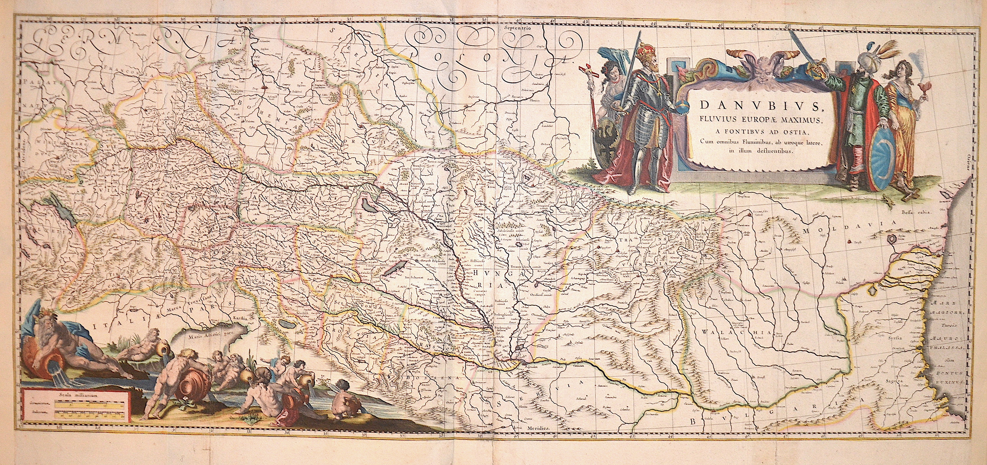
Danubius, Fluvius Europae maximus, a fontibus ad Osti,….

| Article ID | EUX1047 |
Title | Danubius, Fluvius Europae maximus, a fontibus ad Osti,…. |
Description | Map shows the course of the Danube on two maps with two magnificent cartouches from Tuttlingen it flows through Germany, Austria, Slovakia, Hungary, Croatia, Serbia to Belgrade. The river then flows into the Black Sea via the Danube Delta. |
| Year | ca. 1630 |
Artist | Blaeu (1571-1638) |
Joan Guilliemus Blaeu was the eldest son of Willem Janszoon Blaeu (1571-1638), and was probably born in Alkmaar in the province of Noord-Holland in the final years of the 16th century. He was brought up in Amsterdam, and studied law at the University of Leiden before going into partnership with his father in the 1630s. Although his father Willem had cartographic interests, having studied under the Danish astronomer Tycho Brahe and having manufactured globes and instruments, his primary business was as a printer. It was under the control of Joan that the Blaeu printing press achieved lasting fame by moving towards the printing of maps and expanding to become the largest printing press in Europe in the 17th century. By the 1660s the Theatrum Orbis Terrarum (or Atlas Maior as it had became known by this time) had expanded to between 9 and 12 volumes, depending on the language. With over 3,000 text pages and approximately 600 maps, it was the most expensive book money could buy in the later 17th century. The translation of the text from Latin into Dutch, English, German, French, and Spanish for several volumes created enormous work for those involved in typography and letterpress activities. It is estimated that over 80 men must have been employed full-time in the Blaeu printing house in Bloemgracht, not including engravers who worked elsewhere, with over 15 printing presses running simultaneously, and in 1667 a second press was acquired at Gravenstraat. At the same time as producing the Atlas Maior, Blaeu was also publishing town plans of Italy, maps for globes, and other volumes. At its peak the Blaeu press managed to produce over 1 million impressions from 1,000 copper plates within four years. | |
Historical Description | The Danube is the second largest and second longest river in Europe after the Volga. It flows through or touches ten countries (Germany, Austria, Slovakia, Hungary, Croatia, Serbia, Bulgaria, Romania, the Republic of Moldova and Ukraine) - more than any other river in the world. As early as the seventh century BC, Greeks who came from the Black Sea via the city of Tomis, now Constanța, sailed upstream. Their voyage of discovery ended at the Iron Gate, a rocky cataract section with many shallows, whose dangerous course made it impossible for the Greek ships to continue their journey via the Southern Carpathians and the Serbian Ore Mountains. Under the Romans, the Danube formed the border with the peoples to the north almost from its source to its mouth and also served as a transportation route for troops and to supply the settlements downstream. Charlemagne's route, which was used by Gottfried of Bouillon's army during the First Crusade between 1096 and 1099, also ran along the Danube from Regensburg to Belgrade. In 1529, the Turks reached Vienna (then the center of Central Europe) and besieged it, but were defeated. The Ottomans' expansion along the Danube was thus halted and from the second Battle of Mohács (1687) onwards, they lost land and power again. Alongside the Austrians, however, the Ottoman Empire remained the most important political factor in south-eastern Europe until the final loss of its Balkan territories through the Russo-Turkish Wars (1768-1774) and the Balkan Wars of 1912/13. The Danube was not only the main military and commercial artery, but also the political, cultural and religious border between the Orient and the Occident. In the peace treaty of Versailles after the First World War, the Danube was declared an international river in 1919 along with the Elbe, Memel and Oder. This internationalization of the waterway led to hopes arising in the Danube city of Regensburg in 1925 that the city could connect to the rapidly developing international air traffic. Flughafen GmbH Regensburg had a water landing site on the Danube near Winzer. At the time, seaplanes were seen as a promising technology for the short term and the Royal British Government was planning an airmail route with seaplanes across Europe to India with stopovers on the Danube. The plans came to nothing in 1926 / 27 after the rapid development of aviation technology. |
| Place of Publication | Amsterdam |
| Dimensions (cm) | 41 x 96 cm |
| Condition | Some resorations at centerfold, right and left margin replaced |
| Coloring | original colored |
| Technique | Copper print |
Reproduction:
237.00 €
( A reproduction can be ordered individually on request. )