

Adina Sommer
Antique and Contemporary Art
Winzerer Str. 154
80797 München
telephone
+49 89 304714
business hours:
by appointment
Email
![]()


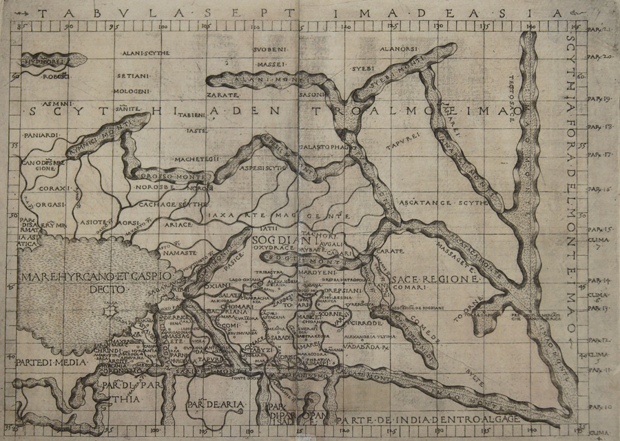
Tabula Septima De Asia

| Article ID | EUO2574 |
Title | Tabula Septima De Asia |
Description | Map shows the caspian sea with Kazakhstan, Uzbekistan and Hindu Kush. Rivers and mountains are roughly shown in the country on the side the climatically zones. Ptolomey watermark on the right side. Very rare! |
| Year | ca. 1482 |
Artist | Ptolemy/ Berlinghieri (1440-1501) |
Francesco Berlinghieri (1440–1501) was an Italian scholar and humanist who lived during the fifteenth century. He promoted the value of classical Greek learning and was one of the first to print a text based on Ptolemy's Geographica. Claudius Ptolemy ( arround 100- 160 a.C.) Geographia, gives a list of geographic coordinates of spherical longitude and latitude of almost ten thousand point locations on the earth surface, as they were known at his times. The list is organized in Tabulae which cor- respond to specific regions of the three known continents at that time, Africa, Asia and Europe. Research on Ptolemy’s Geographia has started at the University of Thessaloniki, Greece, in the eighties, focused mainly, but not exclusively, on data re- lated to territories which are now under the sovereignty of the modern Greek state. The World of Ptolemy is classified in Regions, since each Chapter is referred to one of them, giving by this way the concept of Atlas as it is understood today. Berlinghieris edition of Ptolemy is unique, in that it includes 31 maps covering Europe, northern Africa and the south part of Asia and is the first atlas to attempt the introduction of modern geography, with the inclusion of four new maps - France, Italy, Spain and Palestine, which are based on contemporary knowledge. Rather than a strict plotting of Ptolemys coordinates. A number of other maps in the Berlinghieri edition of Ptolemy include data which is drawn from modern sources, albeit more subtlely so, in part because of transcription errors and in part because of corrections made over time by later scholars. | |
Historical Description | Since the Caspian Sea is not a sea in the legal sense, it is not subject to the 1994 Convention on the Law of the Sea. The oldest cultural evidence can be found on inscriptions on Assyrian pottery and call it a "Southern Sea". the first popular name refers to the tribe of the Caspians who lived on the southwestern bank of the Caspian Caucasus, in today's Azerbaijan, the second refers to the bank near Hyrkania, a landscape on today's Iranian and southern Turkmen coast. The changing history of settlement led to numerous other names such as B. the Tatar name "Ag Deniz", White Sea. |
| Place of Publication | Florenz |
| Dimensions (cm) | 33 x 47,50 |
| Condition | sheets joined together |
| Coloring | original colored |
| Technique | Copper print |
Reproduction:
1,023.00 €
( A reproduction can be ordered individually on request. )