

Adina Sommer
Antique and Contemporary Art
Winzerer Str. 154
80797 München
telephone
+49 89 304714
business hours:
by appointment
Email
![]()


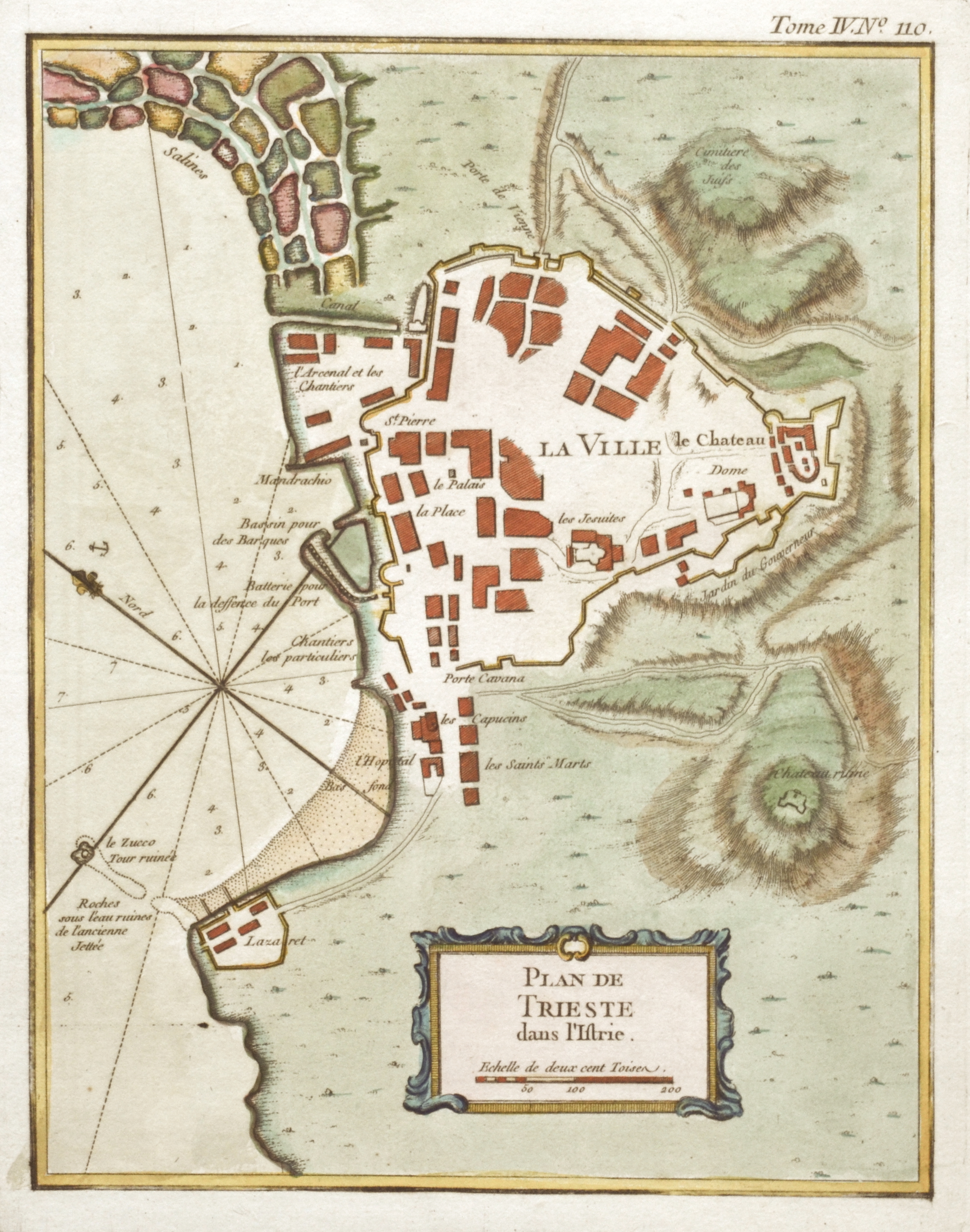
Plan de Trieste dans l’Istrie.

| Article ID | EUI4104 |
Title | Plan de Trieste dans l’Istrie. |
Description | Detailed city map of Triest at the Golf of Triese in northern Italy. |
| Year | ca. 1764 |
Artist | Bellin (1703-1772) |
Jacques-Nicolas Bellin (1703 Paris -1772 Versailles) was a French cartographer, engineer-geographer, marine hydrographer. As a contributor to the Encyclopédie, he wrote more than a thousand articles on maritime topics. As a cartographer, Bellin distinguished himself primarily in the field of sea cartography. From 1721 he worked for the Dépot des Cartes et Plans de la Marine, from 1741 until his death as an engineer-hydrograph of the Navy. In 1753 his atlas Neptune français, which covered all the coasts of France, was published, and in 1756 the hydrography françoise covering all seas of the earth. In 1764 the five-volume Petit Atlas maritime was published, which Bellin prepared on the orders of the Minister of the Navy, Choiseul. In addition, he wrote a number of geographical works and with Nouvelle méthode pour apprendre la geographie (1769) a geographic textbook for teaching. His maps illustrated, among other things, Bougainville's work Voyage autour du monde, published in 1771. As a co-author of the Encyclopédie edited by Diderot and d'Alembert, Bellin wrote more than a thousand articles in the field of shipping and navy. | |
Historical Description | At the time of the foundation of Aquileia by the Romans, the area around Trieste was inhabited by Celtic and Illyrian tribes. Trieste was Habsburg-Austrian from 1382 to 1918. On September 30, 1382, Duke Leopold III accepted the voluntary submission of the city of Trieste in the castle of Graz. Apart from repeated brief occupations (especially in 1508/09) by Venice and the Napoleonic period, Trieste remained part of Habsburg Austria until the end of the First World War. Trieste's rise in the Danube Monarchy began in 1719 with Charles VI's elevation of the city to free port status - a status it retained until 1891. Charles' successors Maria Theresa and Joseph II supported Trieste's economic boom by creating important urban quarters, the "Maria Theresa City" (Borgo Teresiano) northeast of today's main square and the "Joseph City" (Borgo Giuseppino) southwest. In 1804 Trieste became part of the newly founded Empire of Austria, further as part of the Littoral. Under Napoleon, Trieste was added to the Illyrian Provinces in 1809 and thus became French until 1814. This short period left its mark in neoclassical buildings such as the Trieste Opera Teatro Verdi, built according to the plans of the architect Matthaeus Pertsch. In 1813, Austria reconquered Trieste under General Christoph Freiherr von Lattermann. After the Congress of Vienna in 1815, Trieste was incorporated into the newly created Kingdom of Illyria within the Austrian Empire. Trieste, together with Istria and Eastern Friuli, was formally annexed to Italy only in 1919. |
| Place of Publication | Paris |
| Dimensions (cm) | 22 x 17,5 cm |
| Condition | Perfect condition |
| Coloring | original colored |
| Technique | Copper print |
Reproduction:
51.00 €
( A reproduction can be ordered individually on request. )