

- Alsace
- Aquitaine
- Auvergne
- Bourgogne
- Bourgogne-Franche-Comté
- Brittany
- Centre
- Champagne
- Flandre
- France Islands
- Gascogne
- Gironde
- Hauts-de-France
- Ile de France
- Languedoc
- Lothringen
- Midi-Pyrénées
- Nivernais
- Nord-Pas-de-Calais
- Normandie
- Occitanie
- Paris
- Pas-de-Calais
- Pays de la Loire
- Picardie
- Poitou-Charentes
- Provence-Alpes-Cote d Azur
- Pyrénées
- Rhone- Alpes
- Saintonge
- Savoyen
- Tourain
- Westcoast
Adina Sommer
Antique and Contemporary Art
Winzerer Str. 154
80797 München
telephone
+49 89 304714
business hours:
by appointment
Email
![]()


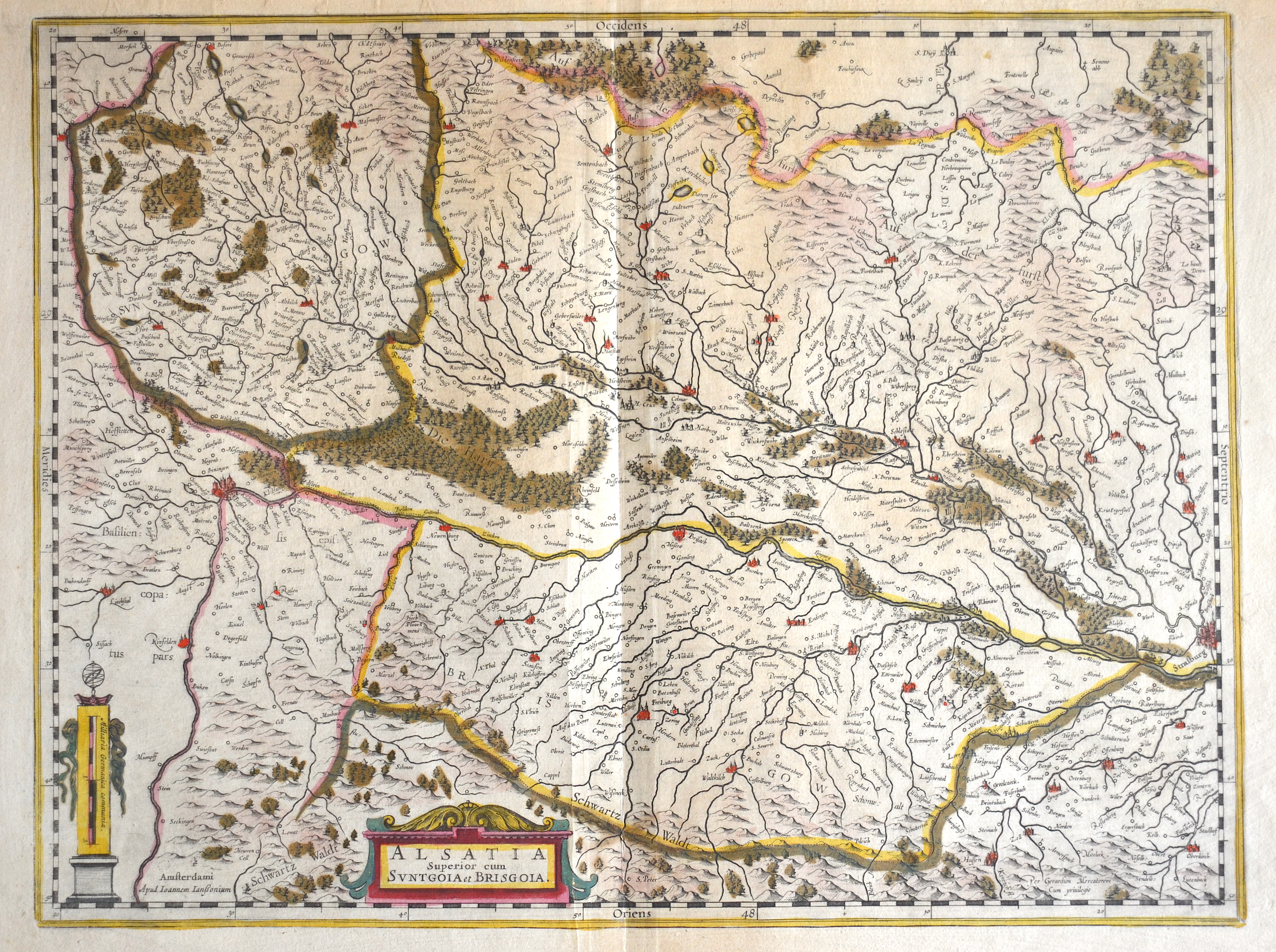
Alsatia Superior cum Suntgoia et Brisgoia.

| Article ID | EUF4207 |
Title | Alsatia Superior cum Suntgoia et Brisgoia. |
Description | Map shows the Alsace with Lothringen and the cities Strassburg, Breisach, Colmar, Freiburg, Basel, etc. |
| Year | ca. 1610 |
Artist | Janssonius (1588-1664) |
Johannes Janssonius (Jansson)( 1588- 1664) Amsterdam, was born in Arnhem, the son of Jan Janszoon the Elder, a publisher and bookseller. In 1612 he married Elisabeth de Hondt, the daughter of Jodocus Hondius. He produced his first maps in 1616 of France and Italy. In 1623 Janssonius owned a bookstore in Frankfurt am Main, later also in Danzig, Stockholm, Copenhagen, Berlin, Königsberg, Geneva and Lyon. In the 1630s he formed a partnership with his brother in law Henricus Hondius, and together they published atlases as Mercator/Hondius/Janssonius. Under the leadership of Janssonius the Hondius Atlas was steadily enlarged. Renamed Atlas Novus, it had three volumes in 1638, one fully dedicated to Italy. 1646 a fourth volume came out with ""English County Maps"", a year after a similar issue by Willem Blaeu. Janssonius' maps are similar to those of Blaeu, and he is often accused of copying from his rival, but many of his maps predate those of Blaeu and/or covered different regions. By 1660, at which point the atlas bore the appropriate name ""Atlas Major"", there were 11 volumes, containing the work of about a hundred credited authors and engravers. It included a description of ""most of the cities of the world"" (Townatlas), of the waterworld (Atlas Maritimus in 33 maps), and of the Ancient World (60 maps). The eleventh volume was the Atlas of the Heavens by Andreas Cellarius. Editions were printed in Dutch, Latin, French, and a few times in German. | |
Historical Description | Alsace is a cultural and historical region in eastern France, on the west bank of the upper Rhine next to Germany and Switzerland. Politicaly the Alsace changed its borders from the 5th century AD tot he 19th century many times. From 1982 to 2016, Alsace was the smallest administrative région in metropolitan France, consisting of the Bas-Rhin and Haut-Rhin departments. Territorial reform passed by the French legislature in 2014 resulted in the merger of the Alsace administrative region with Champagne-Ardenne and Lorraine to form Grand Est. |
| Place of Publication | Amsterdam |
| Dimensions (cm) | 36 x 47,5 cm |
| Condition | Break on the center because of oxidation, professional restored |
| Coloring | original colored |
| Technique | Copper print |
Reproduction:
61.50 €
( A reproduction can be ordered individually on request. )