

- Alsace
- Aquitaine
- Auvergne
- Bourgogne
- Bourgogne-Franche-Comté
- Brittany
- Centre
- Champagne
- Flandre
- France Islands
- Gascogne
- Gironde
- Hauts-de-France
- Ile de France
- Languedoc
- Lothringen
- Midi-Pyrénées
- Nivernais
- Nord-Pas-de-Calais
- Normandie
- Occitanie
- Paris
- Pas-de-Calais
- Pays de la Loire
- Picardie
- Poitou-Charentes
- Provence-Alpes-Cote d Azur
- Pyrénées
- Rhone- Alpes
- Saintonge
- Savoyen
- Tourain
- Westcoast
Adina Sommer
Antique and Contemporary Art
Winzerer Str. 154
80797 München
telephone
+49 89 304714
business hours:
by appointment
Email
![]()


The Harbour of St. Malo and Road of Rance.
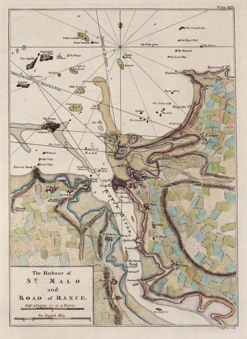

| Article ID | EUF3532 |
Title | The Harbour of St. Malo and Road of Rance. |
Description | Detailed map of the harbour of Malo and road of Rance in Bretagne, France. |
| Year | ca. 1760 |
Artist | Jefferys (1719-1771) |
Thomas Jefferys "Geographer to King George III", was an English cartographer who was the leading map supplier of his day. He engraved and printed maps for government and other official bodies and produced a wide range of commercial maps and atlases, especially of North America | |
| Place of Publication | London |
| Dimensions (cm) | 27,5 x 20 |
| Condition | Perfect condition |
| Coloring | original colored |
| Technique | Copper print |
Reproduction:
34.50 €
( A reproduction can be ordered individually on request. )