

- Alsace
- Aquitaine
- Auvergne
- Bourgogne
- Bourgogne-Franche-Comté
- Brittany
- Centre
- Champagne
- Flandre
- France Islands
- Gascogne
- Gironde
- Hauts-de-France
- Ile de France
- Languedoc
- Lothringen
- Midi-Pyrénées
- Nivernais
- Nord-Pas-de-Calais
- Normandie
- Occitanie
- Paris
- Pas-de-Calais
- Pays de la Loire
- Picardie
- Poitou-Charentes
- Provence-Alpes-Cote d Azur
- Pyrénées
- Rhone- Alpes
- Saintonge
- Savoyen
- Tourain
- Westcoast
Adina Sommer
Antique and Contemporary Art
Winzerer Str. 154
80797 München
telephone
+49 89 304714
business hours:
by appointment
Email
![]()


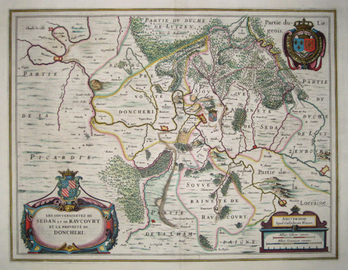
Les souverainetez de Sedan et de Raucourt et la prévosté de Doncheri….

| Article ID | EUF2423 |
Title | Les souverainetez de Sedan et de Raucourt et la prévosté de Doncheri…. |
Description | Map shows the Champagne with the cities of Sedan and Doncheri |
| Year | ca. 1610 |
Artist | Blaeu (1571-1638) |
Joan Guilliemus Blaeu was the eldest son of Willem Janszoon Blaeu (1571-1638), and was probably born in Alkmaar in the province of Noord-Holland in the final years of the 16th century. He was brought up in Amsterdam, and studied law at the University of Leiden before going into partnership with his father in the 1630s. Although his father Willem had cartographic interests, having studied under the Danish astronomer Tycho Brahe and having manufactured globes and instruments, his primary business was as a printer. It was under the control of Joan that the Blaeu printing press achieved lasting fame by moving towards the printing of maps and expanding to become the largest printing press in Europe in the 17th century. By the 1660s the Theatrum Orbis Terrarum (or Atlas Maior as it had became known by this time) had expanded to between 9 and 12 volumes, depending on the language. With over 3,000 text pages and approximately 600 maps, it was the most expensive book money could buy in the later 17th century. The translation of the text from Latin into Dutch, English, German, French, and Spanish for several volumes created enormous work for those involved in typography and letterpress activities. It is estimated that over 80 men must have been employed full-time in the Blaeu printing house in Bloemgracht, not including engravers who worked elsewhere, with over 15 printing presses running simultaneously, and in 1667 a second press was acquired at Gravenstraat. At the same time as producing the Atlas Maior, Blaeu was also publishing town plans of Italy, maps for globes, and other volumes. At its peak the Blaeu press managed to produce over 1 million impressions from 1,000 copper plates within four years. | |
Historical Description | Champagne is a landscape and historical province in north-eastern France. Its historical capital is the city of Troyes. In ancient times, Champagne was the settlement area of the Celtic Catalauni. After the conquest of Gaul (58-51 BC) by Gaius Julius Caesar, it became part of the Roman province of Gallia Belgica. Alongside Saint-Denis, Reims became the most important religious center in France. Until 1825, all French kings were crowned and anointed in Reims Cathedral. During the Middle Ages, Champagne was a county whose counts were among the most powerful princes in France. Thanks to the great fairs in Reims and Troyes, the region became one of the most economically important in Europe. In the 18th and 19th centuries, the textile and metal industries developed here, losing some of their importance after 1930 and all of it after 1970. |
| Place of Publication | Amsterdam |
| Dimensions (cm) | 38 x 50 |
| Condition | Very good |
| Coloring | original colored |
| Technique | Copper print |
Reproduction:
64.50 €
( A reproduction can be ordered individually on request. )