

Adina Sommer
Antique and Contemporary Art
Winzerer Str. 154
80797 München
telephone
+49 89 304714
business hours:
by appointment
Email
![]()


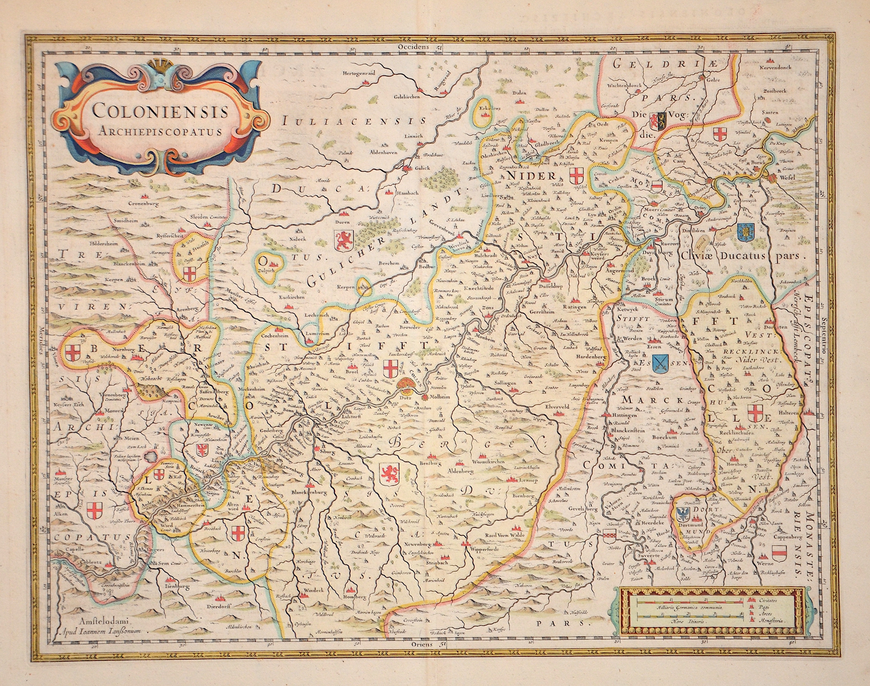
Coloniensis Archiepiscopatus

| Article ID | EUD999 |
Title | Coloniensis Archiepiscopatus |
Description | Map shows the surroundings of Cologne with many depictions of coats of arms in the country. There is also a splendid title cartouche and a mileage indicator cartouche. |
| Year | ca. 1664 |
Artist | Janssonius (1588-1664) |
Johannes Janssonius (Jansson)( 1588- 1664) Amsterdam, was born in Arnhem, the son of Jan Janszoon the Elder, a publisher and bookseller. In 1612 he married Elisabeth de Hondt, the daughter of Jodocus Hondius. He produced his first maps in 1616 of France and Italy. In 1623 Janssonius owned a bookstore in Frankfurt am Main, later also in Danzig, Stockholm, Copenhagen, Berlin, Königsberg, Geneva and Lyon. In the 1630s he formed a partnership with his brother in law Henricus Hondius, and together they published atlases as Mercator/Hondius/Janssonius. Under the leadership of Janssonius the Hondius Atlas was steadily enlarged. Renamed Atlas Novus, it had three volumes in 1638, one fully dedicated to Italy. 1646 a fourth volume came out with ""English County Maps"", a year after a similar issue by Willem Blaeu. Janssonius' maps are similar to those of Blaeu, and he is often accused of copying from his rival, but many of his maps predate those of Blaeu and/or covered different regions. By 1660, at which point the atlas bore the appropriate name ""Atlas Major"", there were 11 volumes, containing the work of about a hundred credited authors and engravers. It included a description of ""most of the cities of the world"" (Townatlas), of the waterworld (Atlas Maritimus in 33 maps), and of the Ancient World (60 maps). The eleventh volume was the Atlas of the Heavens by Andreas Cellarius. Editions were printed in Dutch, Latin, French, and a few times in German. | |
Historical Description | The first written account of the area was by its conqueror, Julius Caesar, the territories west of the Rhine were occupied by the Eburones and east of the Rhine he reported the Ubii (across from Cologne) and the Sugambri to their north. The Ubii and some other Germanic tribes such as the Cugerni were later settled on the west side of the Rhine in the Roman province of Germania Inferior. Julius Caesar conquered the tribes on the left bank, and Augustus established numerous fortified posts on the Rhine, but the Romans never succeeded in gaining a firm footing on the right bank, where the Sugambri neighboured several other tribes including the Tencteri and Usipetes. North of the Sigambri and the Rhine region were the Bructeri. and by the end of the fifth century had conquered all the lands that had formerly been under Roman influence. By the eighth century, the Frankish dominion was firmly established in western Germany and northern Gaul, but at the same time, to the north, Westphalia was being taken over by Saxons pushing south. As the central power of the Holy Roman Emperor weakened, the Rhineland split into numerous small, independent, separate vicissitudes and special chronicles. Prussia first set foot on the Rhine in 1609 by the occupation of the Duchy of Cleves and about a century later Upper Guelders and Moers also became Prussian. At the peace of Basel in 1795, the whole of the left bank of the Rhine was resigned to France, and in 1806, the Rhenish princes all joined the Confederation of the Rhine. After the Congress of Vienna, Prussia was awarded the entire Rhineland, which included the Grand Duchy of Berg, the ecclesiastic electorates of Trier and Cologne, the free cities of Aachen and Cologne, and nearly a hundred small lordships and abbeys. The Prussian Rhine province was formed in 1822 and Prussia had the tact to leave them in undisturbed possession of the liberal institutions to which they had become accustomed under the republican rule of the French. In 1920, the districts of Eupen and Malmedy were transferred to Belgium (see German-speaking Community of Belgium). After the Congress of Vienna, the Kingdom of Prussia received a large amount of territory in the Westphalian region and created the province of Westphalia in 1815. The northernmost portions of the former kingdom, including the town of Osnabrück, had become part of the states of Hanover and Oldenburg. |
| Place of Publication | Amsterdam |
| Dimensions (cm) | 37,5 x 48,5 cm |
| Condition | Wide margins, perfect condition |
| Coloring | original colored |
| Technique | Copper print |
Reproduction:
63.00 €
( A reproduction can be ordered individually on request. )