

Adina Sommer
Antique and Contemporary Art
Winzerer Str. 154
80797 München
telephone
+49 89 304714
business hours:
by appointment
Email
![]()


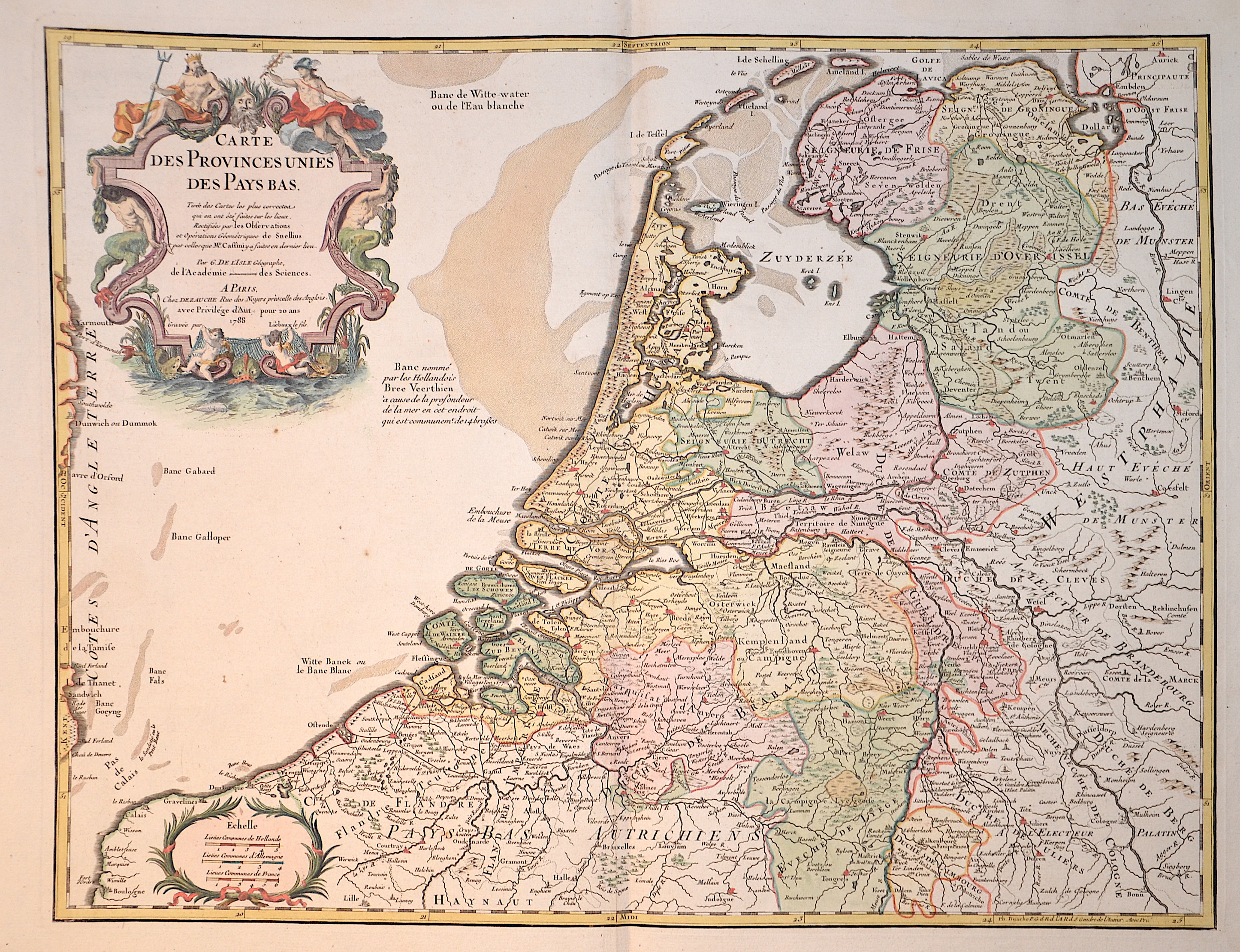
Carte des Provinces unies des Pays Bas.

| Article ID | EUB2766 |
Title | Carte des Provinces unies des Pays Bas. |
Description | Map shows the whole of the Netherlands with part of Belgium. Furthermore a splendid title cartouche and a mileage scale cartouche. |
| Year | dated 1788 |
Artist | Dezauche/de l´Isle, (1780-1838) |
Jean-Claude Dezauche (1780-1838) was the successor to Guillaume De L'Isle and Philipe Buache. Guillaume De L´Isle (1675- 1726) Paris, was a French cartographer known for his popular and accurate maps of Europe and the newly explored Americas and Africa. De L´Isle was admitted into the French Académie Royale des Sciences, an institution financed by the French state. After that date, he signed his maps with the title of “Géographe de l’Académie”. Five years later, he moved to the Quai de l’Horloge in Paris, a true publishing hub where his business prospered. De L´Isle’s ascension through the ranks culminated in 1718 when he received the title of Premier Géographe du Roi. His new office consisted in teaching geography to the Dauphin, King Louis XIV’s son, a task for which he received a salary. De L´Isle’s reputation as a man of science probably helped .This supports the claim of the historian Mary Sponberg Pedley, who says “once authority was established, a geographer’s name might retain enough value to support two or three generations of mapmakers”. In De L´Isle’s case, it could be said that his accomplishments surpassed his father’s. Up to that point, he had drawn maps not only of European countries, such as Italy, Spain, Germany, Great Britain, Poland, and regions such as the Duchy of Burgundy, but he had also contributed to the empire’s claims to recently explored continents of Africa and the Americas. Like many cartographers of these days, De L´Isle did not travel with the explorers and elaborated the maps mostly in his office. The quality of his maps depended on a solid network that would provide him first-hand information. Given the family’s reputation and his own, De L´Isle had access to fairly recent accounts of travellers who were coming back from the New World, which gave him an advantage over his competitors. Being a member of the Académie, he was also aware of recent discoveries, especially in astronomy and measurement. When he could not confirm the accuracy of his source, he would indicate it clearly on his maps. For instance, his Carte de la Louisiane shows a river that the baron of Lahontan claimed he discovered, but no one else could validate it, so De L`lsle warned the viewer that its actual existence was in doubt. De L´Isle 's search for exactitude and intellectual honesty entangled him in a legal dispute in 1700 with Jean-Baptiste Nolin, a fellow cartographer. Noticing Nolin had used details that were considered original from his Map of the World, De L´isle dragged Nolin in court to prove his plagiarism. In the end, Delisle managed to convince the jury of scientists that Nolin only knew the old methods of cartography and therefore that he had stolen the information from his manuscript. Nolin's maps were confiscated and he was forced to pay the court costs.The scientificity of the work produced by the De L´Isle family contrasted with the workshop of Sanson. While Sanson knowingly published outdated facts and mistakes, De L´Isle strived to present up-to-date knowledge. | |
Historical Description | After the division of the Franconian Empire, the lower lands belonged to the East Franconian Kingdom (Regnum Teutonicum) and then to the Holy Roman Empire. Under Emperor Charles V, who was also King of Spain, the country was divided into seventeen provinces and also included what is now Belgium and parts of northern France and western Germany. The rift between Catholics loyal to Spain and radical Calvinists was torn too deep and led to the Calvinist provinces of Holland, Zeeland and Utrecht joining together in a defensive alliance in 1579, the Union of Utrecht. This treaty became the charter of a new state, the Republic of the United Netherlands. Only after an eighty-year war was the independence of the Netherlands from Spain recognized in the Peace of Westphalia in May 1648. This date is considered the birthday of today's Netherlands. As a result, as the republic of the Seven United Provinces, the Netherlands grew to become the greatest trading and economic power of the 17th century. This era is known as the Golden Age. However, this did not come from the state, but from the first two public companies in history, the Dutch East India Company (VOC) and the Dutch West India Company (WIC). The founding of New Amsterdam is well known (Nieuw Amsterdam), which was later renamed New York. In Asia, the Dutch created their colonial empire, the Dutch East Indies, what is now Indonesia. The Netherlands also gained colonies in northeastern South America. In Europe, the Netherlands was a great power in the 17th century, led by bourgeois politicians like Johan van Oldenbarnevelt and Johan de Witt. |
| Place of Publication | Paris |
| Dimensions (cm) | 47 x 61,5 cm |
| Condition | Perfect condition |
| Coloring | original colored |
| Technique | Copper print |
Reproduction:
55.50 €
( A reproduction can be ordered individually on request. )