

Adina Sommer
Antique and Contemporary Art
Winzerer Str. 154
80797 München
telephone
+49 89 304714
business hours:
by appointment
Email
![]()


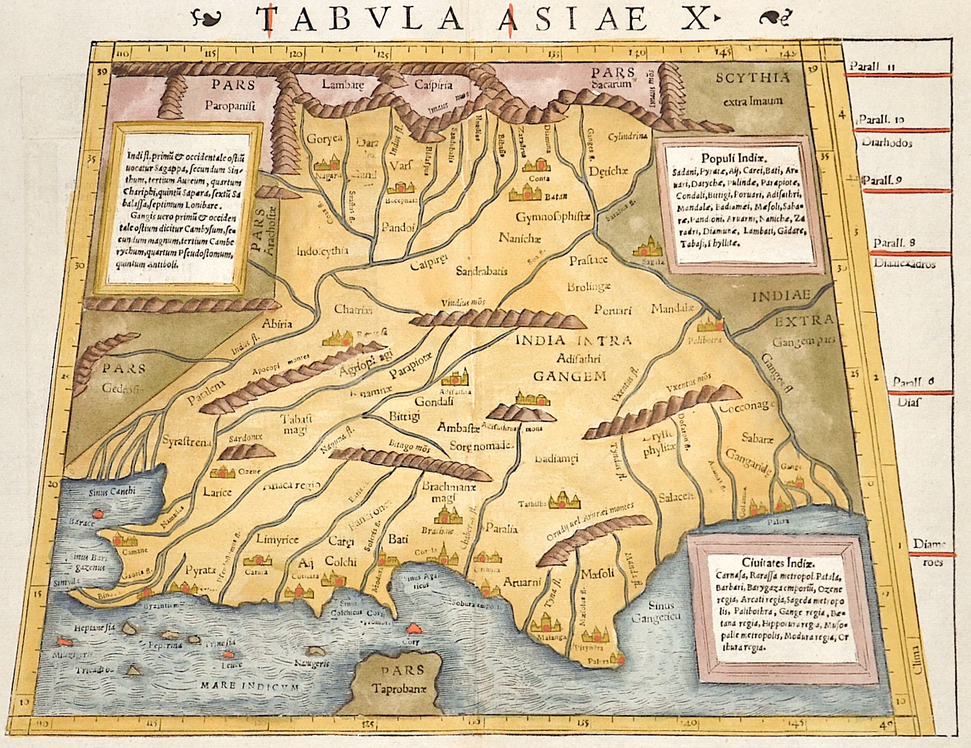
Tabula Asiae X

| Article ID | ASI1012 |
Title | Tabula Asiae X |
Description | Map shows India with the river Ganges, Irak, and Iran. Decorative ornamental title on reverse. |
| Year | ca. 1550 |
Artist | Ptolemy/Münster Sebastian (1489-1552) |
Sebastian Münster (1488 – 1552) belongs to the very important Comographers oft he Renaicance. He issued his first famous Cosmographia in 1544 with 24 double paged maps with German description of the world.It had numerous editions in different languages including Latin, French, Italian, English, and Czech. The last German edition was published in 1628, long after his death. The Cosmographia was one of the most successful and popular books of the 16th century. It passed through 24 editions in 100 years. This success was due to the notable woodcuts ,some by Hans Holbein the Younger, Urs Graf, Hans Rudolph Deutsch, and David Kandel. It was most important in reviving geography in 16th-century Europe.His first geographic works were Germania descriptio (1530) and Mappa Europae (1536). In 1540 he published a Latin edition of Ptolemy's Geographia with illustrations. The 1550 edition contains cities, portraits, and costumes. These editions, printed in Germany, are the most valued of the Cosmographias. Claudius Ptolemy (arround 100- 160 a.C.) Geographia, gives a list of geographic coordinates of spherical longitude and latitude of almost ten thousand point locations on the earth surface, as they were known at his times. The list is organized in Tabulae which cor- respond to specific regions of the three known continents at that time, Africa, Asia and Europe. Research on Ptolemy’s Geographia has started at the University of Thessaloniki, Greece, in the eighties, focused mainly, but not exclusively, on data re- lated to territories which are now under the sovereignty of the modern Greek state. The World of Ptolemy is classified in Regions, since each Chapter is referred to one of them, giving by this way the concept of Atlas as it is understood today. | |
Historical Description | After the 10th century, Muslim Central Asian nomadic clans, using swift-horse cavalry and raising vast armies united by ethnicity and religion, repeatedly overran South Asia's north-western plains, leading eventually to the establishment of the Islamic Delhi Sultanate in 1206. The sultanate was to control much of North India and to make many forays into South India. Although at first disruptive for the Indian elites, the sultanate largely left its vast non-Muslim subject population to its own laws and customs. By repeatedly repulsing Mongol raiders in the 13th century, the sultanate saved India from the devastation visited on West and Central Asia, setting the scene for centuries of migration of fleeing soldiers, learned men, mystics, traders, artists, and artisans from that region into the subcontinent, thereby creating a syncretic Indo-Islamic culture in the north. The sultanate's raiding and weakening of the regional kingdoms of South India paved the way for the indigenous Vijayanagara Empire. Embracing a strong Shaivite tradition and building upon the military technology of the sultanate, the empire came to control much of peninsular India and was to influence South Indian society for long afterwards. n the early 16th century, northern India, then under mainly Muslim rulers fell again to the superior mobility and firepower of a new generation of Central Asian warriors. The resulting Mughal Empire did not stamp out the local societies it came to rule. Instead, it balanced and pacified them through new administrative practices and diverse and inclusive ruling elites, leading to more systematic, centralised, and uniform rule. Eschewing tribal bonds and Islamic identity, especially under Akbar, the Mughals united their far-flung realms through loyalty, expressed through a Persianised culture, to an emperor who had near-divine status. The Mughal state's economic policies, deriving most revenues from agriculture and mandating that taxes be paid in the well-regulated silver currency caused peasants and artisans to enter larger markets. Newly coherent social groups in northern and western India, such as the Marathas, the Rajputs, and the Sikhs, gained military and governing ambitions during Mughal rule, which, through collaboration or adversity, gave them both recognition and military experience. By the early 18th century, with the lines between commercial and political dominance being increasingly blurred, a number of European trading companies, including the English East India Company, had established coastal outposts. The East India Company's control of the seas, greater resources, and more advanced military training and technology led it to increasingly flex its military muscle and caused it to become attractive to a portion of the Indian elite; these factors were crucial in allowing the company to gain control over the Bengal region by 1765 and sideline the other European companies. |
| Place of Publication | Basle |
| Dimensions (cm) | 26 x 34,5 |
| Condition | Some restoration at centerfold |
| Coloring | colored |
| Technique | Woodcut |
Reproduction:
70.50 €
( A reproduction can be ordered individually on request. )