

Adina Sommer
Antique and Contemporary Art
Winzerer Str. 154
80797 München
telephone
+49 89 304714
business hours:
by appointment
Email
![]()


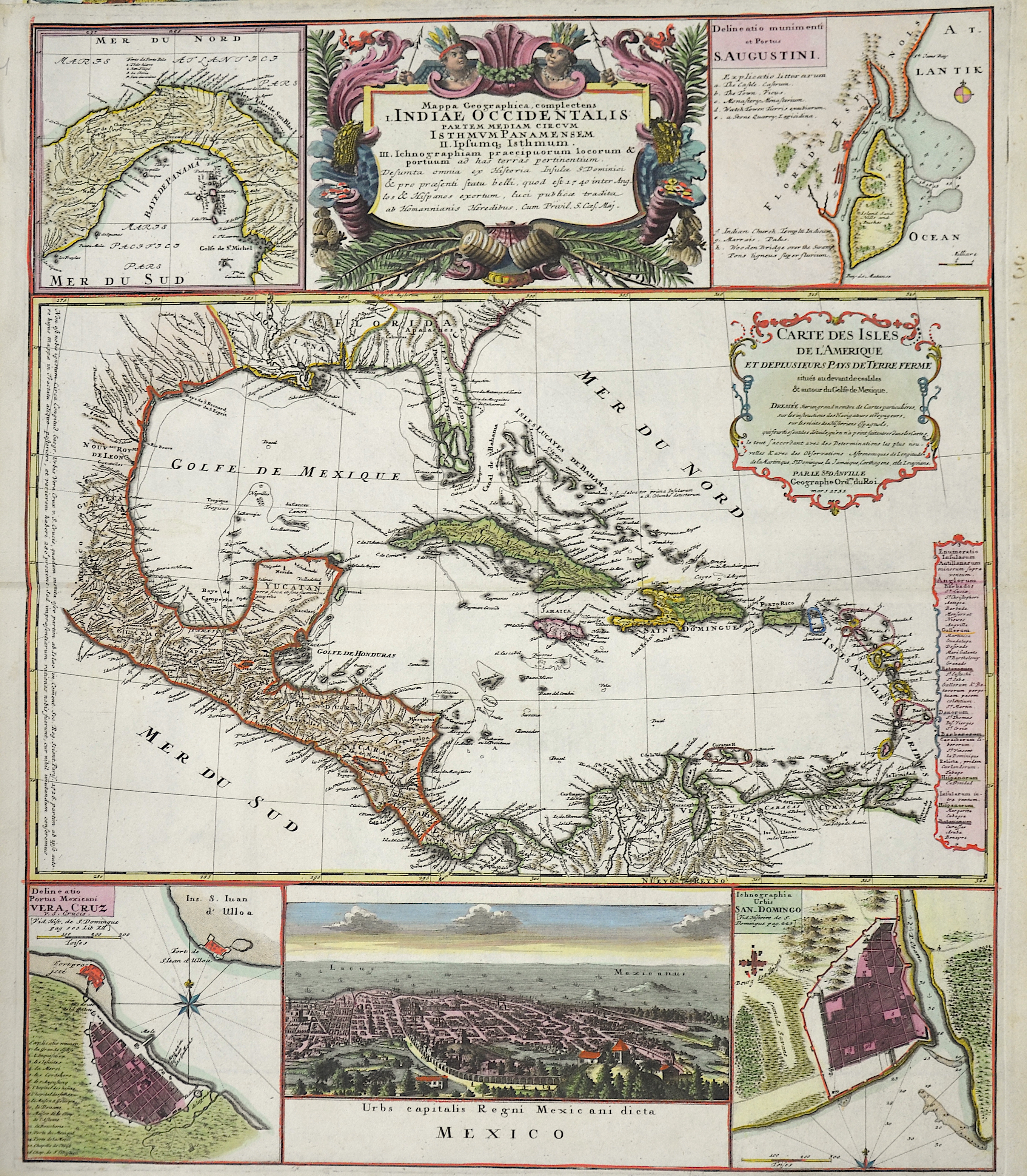
Mappa Geographica, complectens Indiae Occidentalis…

| Article ID | AMZ226 |
Title | Mappa Geographica, complectens Indiae Occidentalis… |
Description | map of Central America, with the Gulf of Mexico and the Caribbean Sea, surrounded by detailed maps, plans and a view of Mexico City |
| Year | ca. 1750 |
Artist | Homann Erben (1724-1780) |
Johann Babtiste Homann (1664-1724) was born in Oberkammlach, the Electorate of Bavaria. Although educated at a Jesuit school, and preparing for an ecclesiastical career, he eventually converted to Protestantism and from 1687 worked as a civil law notary in Nuremberg. He soon turned to engraving and cartography; in 1702 he founded his own publishing house. Homann acquired renown as a leading German cartographer, and in 1715 was appointed Imperial Geographer by Emperor Charles VI. Giving such privileges to individuals was an added right that the Holy Roman Emperor enjoyed. In the same year he was also named a member of the Prussian Academy of Sciences in Berlin. Of particular significance to cartography were the imperial printing privileges (Latin: privilegia impressoria). These protected for a time the authors in all scientific fields such as printers, copper engravers, map makers and publishers. They were also very important as a recommendation for potential customers. In 1716 Homann published his masterpiece Grosser Atlas ueber die ganze Welt (Grand Atlas of all the World). Numerous maps were drawn up in cooperation with the engraver Christoph Weigel the Elder, who also published Siebmachers Wappenbuch. Homann died in Nuremberg. He was succeeded by the Homann heirs company, which was in business until 1848. The company was known as Homann Erben, Homanniani Heredes, or Heritiers de Homann abroad. | |
Historical Description | Central America includes both the region of Central America and the West Indian Islands. The history of Central America is marked by profound cultural, political, and social changes. From the glorious indigenous civilizations to the dark era of colonization and the challenges of the modern world, Central America remains a region in constant transformation and of great historical significance. In pre-Columbian times, Central America was home to numerous influential cultures. The Maya were one of the most advanced civilizations of the pre-Columbian world and inhabited an area that today includes parts of Mexico, Guatemala, Belize, Honduras, and El Salvador. The Aztecs primarily lived in Central Mexico, and the Olmecs are considered one of the oldest cultures in Mesoamerica.In the 16th century, European colonization of Central America began under Hernán Cortés, who conquered the Aztec Empire in 1521, marking the beginning of Spanish rule in Mesoamerica. In 1524, Pedro de Alvarado began the conquest of the Maya regions in Guatemala and other parts of Central America. When Columbus landed on San Salvador (Bahamas) in 1492 under the Spanish crown, he was primarily searching for gold and other riches. However, the Arawaks placed no value on what Europeans considered wealth. Thus, while the Caribbean was settled, the conquistadors soon turned their attention to the American continent. Gradually, the English, Dutch, and French also settled in the region.By the end of the 16th century, the region was mostly under Spanish control, and the Spanish colonization led to profound changes, particularly through the introduction of Catholicism, the destruction of indigenous cultures, and the reshaping of the social structure. In the early 19th century, the independence struggle in Central America began, influenced by the independence movements in other parts of Latin America. |
| Place of Publication | Nuremberg |
| Dimensions (cm) | 58 x 49 |
| Condition | Very good |
| Coloring | original colored |
| Technique | Copper print |
Reproduction:
187.50 €
( A reproduction can be ordered individually on request. )