

Adina Sommer
Antique and Contemporary Art
Winzerer Str. 154
80797 München
telephone
+49 89 304714
business hours:
by appointment
Email
![]()


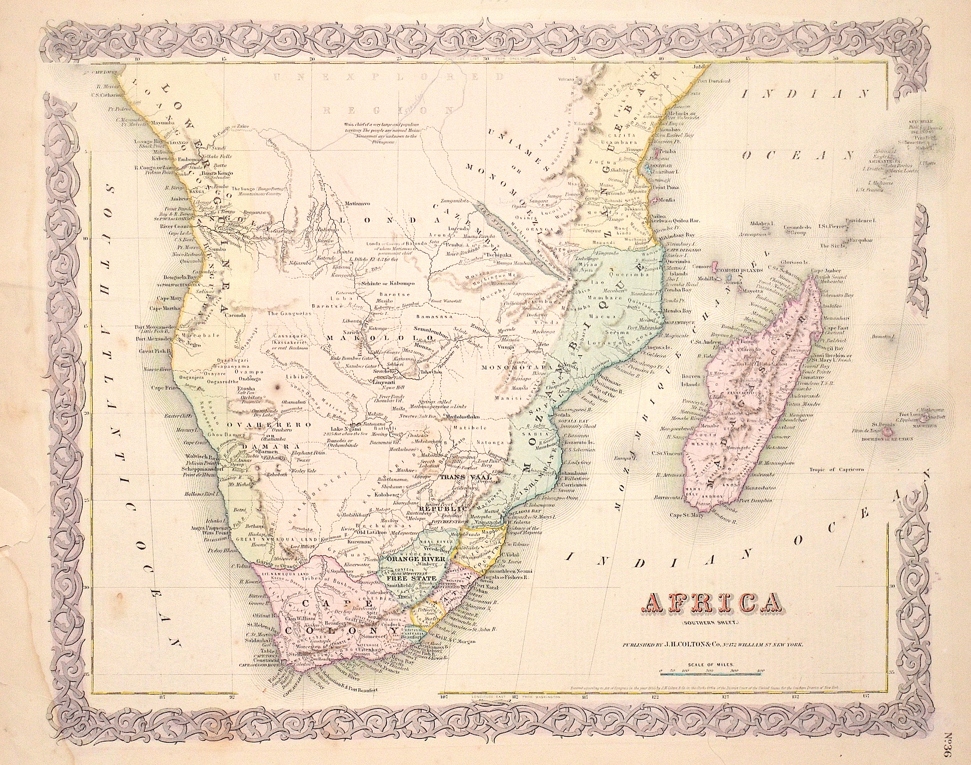
Africa (Sothern Sheet.)

| Article ID | AF0471 |
Title | Africa (Sothern Sheet.) |
Description | Map shows South Africa to the equator with Madagascar, the Seychelles, the Amirantes, Mauritius and the island of Reunion in the Indian Ocean. |
| Year | c. 1855 |
Artist | Colton/Hutchins (1800-1893) |
Joseph Hutchins Colton (1800 –1893), known professionally as J.H. Colton, founded an American mapmaking company which was an international leader in the map publishing industry between 1831 and 1890. For the first ten years, Colton licensed the use of maps from established cartographers such as David H. Burr. Colton also employed some of the preeminent engravers of the time, including Burr, Samuel Stiles, John Disturnell and D. Griffing Johnson. Colton went on to create railroad maps, immigrant guides, folding pocket maps, large wall maps, and elaborate atlases. | |
Historical Description | Some of the world's oldest paleoanthropological fossils have been unearthed in South Africa. After these pre-humans, various species of the Homo genus such as Homo habilis, Homo naledi, Homo erectus and finally modern man, Homo sapiens, lived here. The beginning of modern historiography in South Africa is set on April 6, 1652, when the Dutchman Jan van Riebeeck built a supply station on the Cape of Good Hope on behalf of the Dutch East India Company (Dutch Vereenigde Oostindische Compagnie, VOC). Due to its strategically favorable location, it was supposed to be a rest stop for merchant ships traveling between Europe and Southeast Asia. During the 17th and 18th centuries, the settlement, which slowly but steadily expanded, was owned by the Netherlands. The settlers initially spread to the western Cape region, which at that time was a retreat for the Khoisan. Several hundred French Huguenots, after being persecuted in France from 1686, came into the country via the Netherlands from 1688 and brought the viticulture culture with them. The French-speaking names of wineries and fruit-growing farms in the western Cape can be traced back to them. After reaching the Bantu settlement border eastwards in 1770, they waged a series of wars - the border wars - against the Xhosa people. The Cape Dutch brought numerous slaves into the country from Indonesia, Madagascar and India. |
| Place of Publication | New York |
| Dimensions (cm) | 32 x 41 cm |
| Condition | Tears at the external margin restored |
| Coloring | original colored |
| Technique | Lithography |
Reproduction:
25.50 €
( A reproduction can be ordered individually on request. )