

Adina Sommer
Antique and Contemporary Art
Winzerer Str. 154
80797 München
telephone
+49 89 304714
business hours:
by appointment
Email
![]()


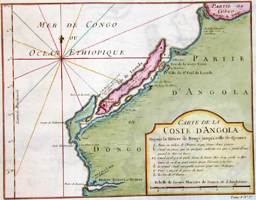
Carte de la coste d´ Angola

| Article ID | AF0220 |
Title | Carte de la coste d´ Angola |
Description | Map shows the northern part of Angola with the city Luanda |
| Year | ca. 1750 |
Artist | Anonymus |
Historical Description | Angola is a country on the west coast of south-central Africa. It is the seventh largest country in Africa. Although inhabited since the Palaeolithic Age, today's Angola was shaped by Portuguese colonization. It began with coastal settlements and trading posts, which were established from the 16th century onwards, and was limited to these for centuries. In 1483, Portuguese trading posts began to be established on the coast, mainly in Luanda and inland a century later also in Benguela. In the 19th century, European settlers slowly and hesitantly began to settle in the interior. The Portuguese colony that became Angola did not have its current borders until the early 20th century due to resistance from groups such as the Cuamato, the Kwanyama and the Mbunda. The Portuguese explorer Diogo Cão reached the area in 1484. The year before, the Portuguese had established relations with the Congo, which at that time stretched from present-day Gabon in the north to the Kwanza River in the south. The Portuguese established their first trading post in Soyo, which today is the northernmost city in Angola, with the exception of the exclave of Cabinda. Paulo Dias de Novais founded São Paulo de Loanda (Luanda) in 1575 with one hundred settler families and four hundred soldiers. Benguela was fortified in 1587 and became a city in 1617. |
| Dimensions (cm) | 20,5 x 26,5 |
| Condition | Very good |
| Coloring | colored |
| Technique | Copper print |
Reproduction:
34.50 €
( A reproduction can be ordered individually on request. )