

Adina Sommer
Antique and Contemporary Art
Winzerer Str. 154
80797 München
telephone
+49 89 304714
business hours:
by appointment
Email
![]()


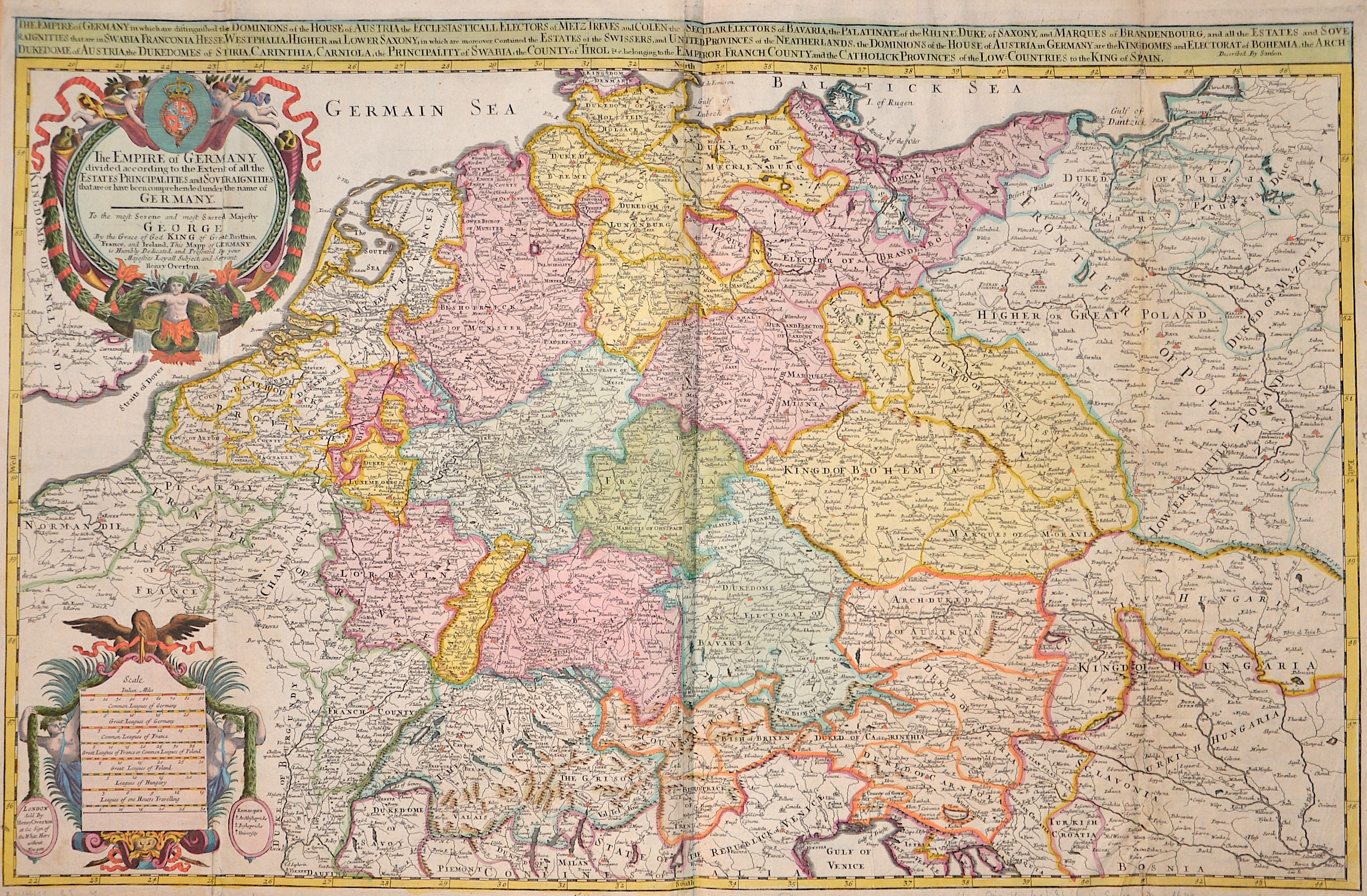
The Empire of Germany in wich are distinguished the Dominions..

| Article ID | EUD5204 |
Title | The Empire of Germany in wich are distinguished the Dominions.. |
Description | Large-format map of Germany, Poland, the Czech Republic, Austria, Switzerland and the Netherlands. Furthermore, two splendid cartouches and a coat of arms depiction. This map was dedicated to King George by Henry Overton, cartographer Guilaume Sanson. |
| Year | ca. 1685 |
Artist | Overton |
The Overton family was a prominent part of the printing, and mapmaking, industry in London in the seventeenth and eighteenth centuries. John Overton (1639/40-1713) was the son of a tailor who apprenticed to Stationer Thomas Gould. He was made free of the Stationers’ Company in 1663. Two years later, London was struck by the Great Plague of 1665-6. Peter Stent, a leading printseller, succumbed and Overton took over his shop. This burned in the Great Fire of 1666, but Overton had rebuilt by 1669, when he advertised his wares from the White Horse on Snow Hill. Overton specialized in prints, portraits, and especially maps and topographical views. John was likely married three times and had seven children. His eldest, Thomas, emigrated to America. His second oldest, Henry, was executor of John’s will when the latter died in 1713. Henry (1675/6-1751) acquired his father’s stock in 1707 and ran the shop until his own death in 1751. He published many maps, most focusing on the British Isles. His shop and stock passed to his nephew, another Henry, son of John’s fourth son, James. Henry the Elder’s brother, Philip (ca. 1681-1745), was also a printer and mapmaker. Philip served as his father’s apprentice and was made free of the Stationers’ in 1702. His father set him up in the trade in 1707 and by 1710 he was working from the sign of the Golden Buck in Fleet Street. Philip specialized in fine arts prints, including Hogarth’s Hudibras set (1726), but he also sold many maps. At his death in 1745 he left his shop to his widow, Mary. She ran the shop and then married James Sayer, whose brother, Robert, became Mary’s assistant. He took over the business in 1748 and became a famous purveyor of maps, charts, and views. Back at the sign of the White Horse, Henry the Younger continued the family business, expanding their stock to include a large collection of landscape views. He often partnered with Robert Sayer. He continued in business until at least 1764, when he drops out of the historical record. | |
Historical Description | The concept of Germany as a distinct region in central Europe can be traced to Roman commander Julius Caesar, who referred to the unconquered area east of the Rhine as Germania, thus distinguishing it from Gaul (France), which he had conquered. In the High Middle Ages, the regional dukes, princes and bishops gained power at the expense of the emperors. Martin Luther led the Protestant Reformationagainst the Catholic Church after 1517, as the northern states became Protestant, while the southern states remained Catholic. The two parts of the Holy Roman Empire clashed in the Thirty Years' War (1618–1648). 1648 marked the effective end of the Holy Roman Empire and the beginning of the modern nation-state system, with Germany divided into numerous independent states, such as Prussia, Bavaria and Saxony. |
| Place of Publication | London |
| Dimensions (cm) | 55,5 x 86 cm |
| Condition | Printed on 2 sheets joined together, folds restored |
| Coloring | original colored |
| Technique | Copper print |
Reproduction:
126.00 €
( A reproduction can be ordered individually on request. )