

Adina Sommer
Antique and Contemporary Art
Winzerer Str. 154
80797 München
telephone
+49 89 304714
business hours:
by appointment
Email
![]()


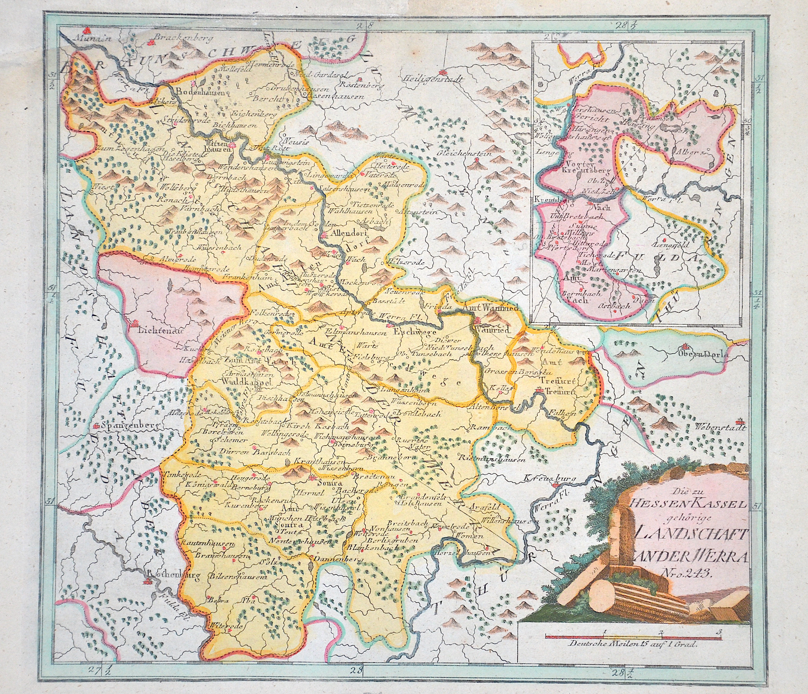
Die zu Hessen Kassel gehörige Landschaft an der Werra Nro. 243.

| Article ID | EUD4984 |
Title | Die zu Hessen Kassel gehörige Landschaft an der Werra Nro. 243. |
Description | Map shows the landscape along the Werra in Hesse with the towns of Eschwege, Allendorf, Wanfried, Hessisch Lichtenau and many more. Furthermore, a partial map with Kreuzberg on the Werra and a title cartouche. |
| Year | ca. 1791 |
Artist | Reilly (1766-1820) |
Franz Johann Joseph von Reilly (1766 - 1820) Vienna. Franz Johann Joseph von Reilly was an Austrian publisher, cartographer and writer. He was born the son of the court master Johann Reilly. He initially worked in the civil service, but then devoted himself exclusively to geography. From 1789 to 1806, he produced the atlas Schauplatz der fünf Theile der Welt, which only covers Europe on its 830 sheets. After the Schul Atlas (1791-92) and the Allgemeine Erdbeschreibung (3 volumes, 1792-93), he published the first (complete) Austrian world atlas entitled Grosser deutscher Atlas from 1794 to 1796. In 1796, he produced the series Geschichtliche und bildliche Vorstellung der Regimenter des Erzhauses Oesterreich (Historical and Pictorial Presentation of the Regiments of the Archduke of Austria), and in 1799 the Allgemeine Post Atlas von der ganzen Welt (General Postal Atlas of the Whole World) - the first atlas of its kind in the world. | |
Historical Description | The history of Hesse in the 16th to 19th centuries was shaped by significant political, religious, and social changes. This period was marked by the Reformation, the Thirty Years' War, the Napoleonic Wars, and changes within the German Confederation. In the 16th century, Hesse was a state in the Holy Roman Empire. The Reformation began in Hesse in 1527, when Landgrave Philip the Magnanimous of Hesse became one of the first German princes to adopt the Lutheran faith. As a result, Hesse became a center of the Reformation, which brought profound religious and political changes to the region. In the 17th century, Hesse was affected by the Thirty Years' War (1618–1648). The war, which plunged Europe into a devastating conflict, also had catastrophic consequences for Hesse. In particular, the mid-century saw economic decline and social hardships. The Peace of Westphalia (1648) ended the war, but its economic and political repercussions were felt for a long time. In the 18th century, Hesse began to stabilize. The state was an important part of the Holy Roman Empire and was governed by the Landgraves of Hesse-Kassel. Hesse-Kassel was a prosperous region, particularly benefiting from tax revenues generated through trade in iron and salt. The early 19th century was shaped by the Napoleonic Wars and the resulting upheavals. In 1806, Hesse-Kassel joined the Confederation of the Rhine and came under French influence. After the end of the Napoleonic era and the decisions of the Congress of Vienna (1815), Hesse-Kassel came under the control of the House of Hesse again but became part of the German Confederation, a loose union of German states. In 1866, Hesse took part in the Austro-Prussian War and, after the conflict, was annexed by Prussia and integrated into the Prussian province of Hesse-Nassau. By the end of the 19th century, Hesse had become part of the newly unified German Empire, established in 1871 under Prussian leadership, and the region experienced a phase of industrialization and modernization. |
| Place of Publication | Vienna |
| Dimensions (cm) | 28 x 30 cm |
| Condition | Upper left corner replaced |
| Coloring | original colored |
| Technique | Copper print |
Reproduction:
25.50 €
( A reproduction can be ordered individually on request. )