

Adina Sommer
Antique and Contemporary Art
Winzerer Str. 154
80797 München
telephone
+49 89 304714
business hours:
by appointment
Email
![]()


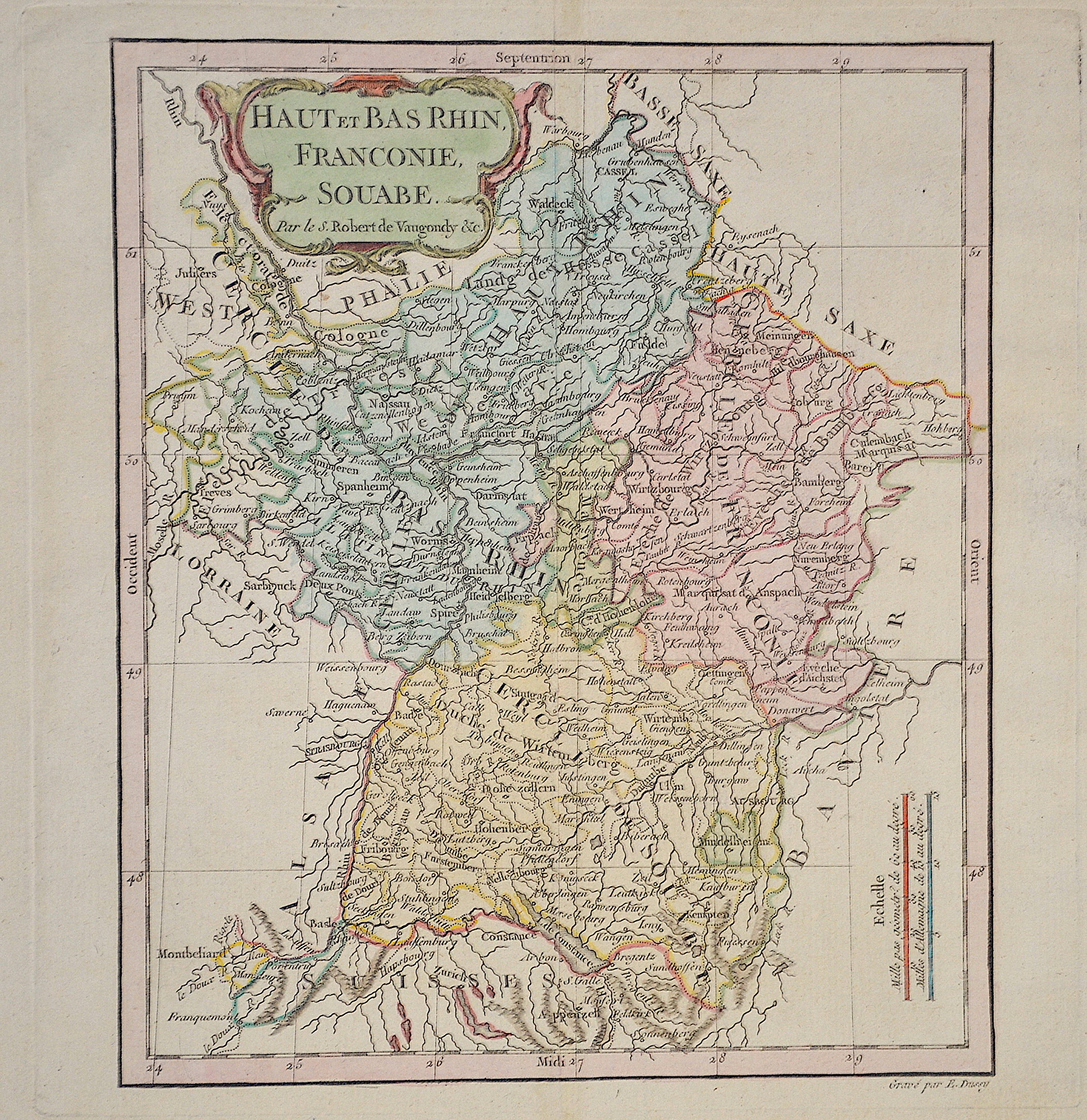
Haut et Bas Rhin, Franconie Souabe.

| Article ID | EUD4948 |
Title | Haut et Bas Rhin, Franconie Souabe. |
Description | Map shows the course of the Rhine from Lake Constance via Freiburg, Heidelberg, Koblenz to Cologne with title cartouche and mileage indicator. Furthermore, the whole of Baden-Württemberg, Swabia, partly Franconia with Würzburg, Bamberg, Ansbach, Koburg; Hesse with Kassel, Waldeck, Frankfurt am Main, Darmstadt; Rhineland-Palatinate with Worms, Trier and many more. |
| Year | ca. 1748 |
Artist | Vaugondy,de (1723-1786) |
Didier Robert de Vaugondy (1723 -1786) also known as Le Sieur or Monsieur Robert, and his son, were leading cartographers in France during the 18th century. In 1757, Gilles and Didier Robert De Vaugondy published The Atlas Universel, one of the most important atlases of the 18th century. To produce the atlas, the Vaugondys integrated older sources with more modern surveyed maps. They verified and corrected the latitude and longitude of many regional maps in the atlas with astronomical observations. The older material was revised with the addition of many new place names. In 1760, Didier Robert de Vaugondy was appointed geographer to Louis XV. Gilles and Didier Robert De Vaugondy produced their maps and terrestrial globes working together as father and son. Globes of a variety of sizes were made by gluing copperplate-printed gores on a plaster-finished papier-mache core, a complicated and expensive manufacturing process, employing several specialists. In some cases it is uncertain whether Gilles or Didier made a given map. Gilles often signed maps as M.Robert, while Didier commonly signed his maps as ""Robert de Vaugondy"", or added ""fils"" or ""filio"" after his name. The Robert de Vaugondys were descended from the Nicolas Sanson family through Sanson's grandson, Pierre Moulard-Sanson. From him, they inherited much of Sanson's cartographic material, which they combined with maps and plates acquired after Hubert Jaillot's death in 1712 to form the basis the Atlas Universel. | |
Historical Description | The Rhine is one of the most important rivers in Europe and has played a significant role in the history and development of the region. It connects several countries, including Switzerland, Germany, France, and the Netherlands. In ancient Europe, the Rhine was an important border, separating the Roman Empire from the Germanic tribes to the north. The Romans used the Rhine as a trade and transport route and built several fortresses along the river to secure their border, including the well-known Limes (border fortifications). The Rhine played a central role in the spread of Roman culture and civilization in the areas along the river. In the Middle Ages, the Rhine was not only an important trade route but also a strategic political point. Cities like Cologne, Mainz, and Speyer along the Rhine developed into important commercial centers. The river was a central part of the Holy Roman Empire and played a key role in the political power dynamics of the region. In the late 18th and early 19th centuries, the Rhine underwent profound changes. During the French Revolution and the Napoleonic Wars, the Rhineland came under French control, and after Napoleon's downfall, it was controlled by Prussia and other German states, becoming an important part of the newly formed German Confederation. In the 19th century, the Rhine experienced significant economic transformation. With the expansion of the railway network and industrialization, the river became an important trade route for raw materials such as coal and iron. Cities like Düsseldorf, Leverkusen, and Mannheim experienced enormous growth and became industrial centers that directly benefited from access to the Rhine. Thus, the course of the Rhine has not only geographical significance but also a profound political, cultural, and economic impact that spans thousands of years. It has shaped both conflict and cooperation and remains a key resource for the countries through which it flows. |
| Place of Publication | Paris |
| Dimensions (cm) | 24 x 20,5 cm |
| Condition | Perfect condition |
| Coloring | original colored |
| Technique | Copper print |
Reproduction:
24.00 €
( A reproduction can be ordered individually on request. )