

Adina Sommer
Antique and Contemporary Art
Winzerer Str. 154
80797 München
telephone
+49 89 304714
business hours:
by appointment
Email
![]()


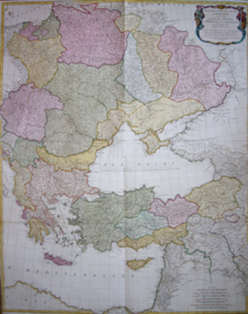
Troisième partie de la Carte d´Europe contenant le midi da la Russie. la Pologne et la Hongie, la Turquie…….

| Article ID | EUO2634 |
Title | Troisième partie de la Carte d´Europe contenant le midi da la Russie. la Pologne et la Hongie, la Turquie……. |
Description | Map shows total eastern Europe with Russia ( Ukrain and Krim), the black sea, Turkey and the eastern Mediterranean sea |
| Year | dated 1760 |
Artist | Anville´d (1697-1782) |
Jean Baptiste Bourguignon d'Anville (1697 -1782), was a French geographer and the reformer of old and new cartography. Bourguignon d'Anville devoted himself early to geographical studies, already in the age of 21 became a royal geographer.With this appointment he later rose as a private secretary of Louis, Duke of Orléans. He published 211 maps and became a member of the Académie des sciences in 1773. His valuable map collection, consisting of 10,500 numbers, was purchased for the Royal Library of Paris, now the Bibliothèque Nationale de France. Jean Baptiste Bourguignon d'Anville, was a geographer and cartographer who greatly improved the standards of map making. Particularly valuable are his maps of ancient geography, which are characterized by careful, accurate work and are largely based on original research. He left unknown areas of continents blank and noted dubious information as such; compared to the elaborate maps of his predecessors, his maps seemed empty. His first serious map, that of ancient Greece, was published when he was fifteen years old. At the age of twenty-two he was appointed one of the king's geographers and began to attract the attention of the first authorities. D'Anville's studies included everything geographical in the world's literature as far as he could find it: To this end, he searched not only ancient and modern historians, travelers, and storytellers of every kind, but also poets, orators, and philosophers. One of his favorite themes was to reform geography by putting an end to blind copying of older maps, by testing the generally accepted positions of places by a rigorous examination of all descriptive authority, and by excluding from cartography any name that was inadequately supported. | |
Historical Description | In the historical sense, Eastern Europe refers to Ukraine, the European part of Russia, Belarus and the Republic of Moldova. Occasionally, the Caucasian countries of Georgia, Armenia and, conditionally, Azerbaijan are also seen as part of Eastern Europe. By Christian Giordano and other scholars, one of the six historical regions of Europe is called "Eastern Europe." The Eastern European countries are historically and culturally largely influenced by the Orthodox Church (Islamic Azerbaijan excepted) and were - in contrast to the Ottoman-dominated Balkans - under the rule of the Russian Empire. Like the Balkan countries, the countries of Eastern Europe were for a long time backward agricultural states (cf.: Intermediate Europe) and had no or only a limited share in the social developments of the Renaissance, Reformation and Enlightenment of the Western world. |
| Place of Publication | Paris |
| Dimensions (cm) | 101 x 80,5 |
| Condition | Printed on 2 sheets joined together |
| Coloring | original colored |
| Technique | Copper print |
Reproduction:
142.50 €
( A reproduction can be ordered individually on request. )