

Adina Sommer
Antique and Contemporary Art
Winzerer Str. 154
80797 München
telephone
+49 89 304714
business hours:
by appointment
Email
![]()


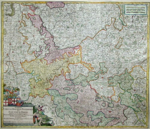
Synopsis Circuli Rhenani Inferioris Cive Electorum Rheni, exhibens Archi-Episcopatum Morguntinum Coloniensem, Trevirensem et Palatinatum Rheni ….

| Article ID | EUD1615 |
Title | Synopsis Circuli Rhenani Inferioris Cive Electorum Rheni, exhibens Archi-Episcopatum Morguntinum Coloniensem, Trevirensem et Palatinatum Rheni …. |
Description | Map shows the River Rhine with Düsseldorf, Cologne. Bonn, Mainz, Worms, Mannheim, Speyer |
| Year | ca. 1730 |
Artist | Seutter (1678-1757) |
Matthias Seutter (1678- 1757) Augsburg was the son of a goldsmith in Augsburg. In 1697, Seutter began his studies in Nuremberg and subsequently worked in the publishing house of Jeremias Wolff in Augsburg. In 1710, he established his own publishing house and print shop. The Seutter publishing house produced a great number of maps, atlases, and globes. However, very few original maps were printed there, as Augsburg at that time had no university and no connection to the fields of mathematics or the natural sciences. Seutter therefore copied the work of other cartographers, making his own engravings based on their models. Over 500 maps were produced in his studio. Seutter's most well-known works are the 1725 "Geographical Atlas or an Accurate Depiction of the Whole World" ("Atlas Geographicus oder Accurate Vorstellung der ganzen Welt") with 46 maps, the 1734 "Large Atlas" ("Grosser Atlas") with 131 maps, and the 1744 pocket atlas "Small Atlas" ("Atlas minor") with 64 maps. Matthäus Seutter died in 1757. Seutter's son Albrecht Karl, his son-in-law Conrad Tobias Lotter, and his business partner Johann Michael Probst ran the printing business for five more years. | |
Historical Description | The headwaters of the Rhine lie predominantly in the Swiss canton of Graubünden; its estuary arms reach the North Sea in the Netherlands, where it is the most water-rich tributary. The Rhine bears its name without distinguishing additions only from the confluence of the Vorderrhein and Hinterrhein at Tamins-Reichenau. Traditionally, Lake Toma near the Oberalp Pass near Sedrun in the Gotthard region is considered the source of the Vorderrhein and the Rhine as a whole. The Hinterrhein rises in the high valley Rheinwald below the Rheinwaldhorn. At Tamins-Reichenau the Vorderrhein and Hinterrhein join to form the Alpenrhein.Hochrhein: The Hochrhein begins at Stein am Rhein at the western end of the Untersee. In contrast to the Alpine Rhine and the Upper Rhine, it flows mainly to the west, dropping from 395 m to 252 m. The Rhine is the first major river in the world. In the center of Basel, the first large city on the course of the stream, lies the "Rhine bend"; here the High Rhine ends. Upper Rhine: At Mainz, the Rhine leaves the Upper Rhine Graben and flows through the Mainz Basin. The section of the Upper Rhine from Mainz down through the Rheingau and Rheinhessen is also known as the Inselrhein. The Upper Rhine Valley was already an important cultural landscape in Europe in ancient times and the Middle Ages. Today, the Upper Rhine is the location of numerous important industrial and service companies with the centers in Basel, Strasbourg and Mannheim-Ludwigshafen. Middle Rhine: The Mainz Basin ends at Bingen. The largest tributaries of the Middle Rhine are the Lahn and Moselle, which flow in from the right and left at Koblenz. Almost the entire length of the Middle Rhine runs through the state of Rhineland-Palatinate. The valley area between Rüdesheim and Koblenz is part of the UNESCO World Heritage Upper Middle Rhine Valley. At Sankt Goarshausen, the Rhine encloses the famous Loreley Rock with a sharp river bend, where it reaches a depth of 25 meters. With its high-ranking architectural monuments, vine-covered slopes, towns crowded together on narrow banks and hilltop castles strung on rocky outcrops, the Middle Rhine Valley is considered the epitome of Rhine Romanticism. Lower Rhine: Near Bonn, north of the Siebengebirge, the Rhine changes from the low mountain region to the North German lowlands and becomes the Lower Rhine at the mouth of the Sieg. The Lower Rhine lies entirely in North Rhine-Westphalia. Its banks are mostly heavily populated and industrialized, especially in the agglomerations of Cologne, Düsseldorf and the Ruhr area. Delta Rhine: At the Dutch-German state border, the Rhine-Meuse delta, the most important natural unit of the Netherlands, begins with the Rhine division, and thus the Delta Rhine. |
| Place of Publication | Augsburg |
| Dimensions (cm) | 49 x 57 |
| Condition | Some folds perfectly set down,upper and lower margin replaced |
| Coloring | original colored |
| Technique | Copper print |
Reproduction:
57.00 €
( A reproduction can be ordered individually on request. )