

Adina Sommer
Antique and Contemporary Art
Winzerer Str. 154
80797 München
telephone
+49 89 304714
business hours:
by appointment
Email
![]()


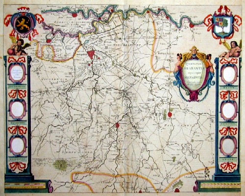
Quarta pars Brabantiae cuius caput sylvaducis
| Article ID | EUN1250 |
Title | Quarta pars Brabantiae cuius caput sylvaducis |
Description | Map shows Einthoven and its environment, with decorative coat of arm panels on the right and left side. |
| Year | ca. 1635 |
Artist | Janssonius (1588-1664) |
Johannes Janssonius (Jansson)( 1588- 1664) Amsterdam, was born in Arnhem, the son of Jan Janszoon the Elder, a publisher and bookseller. In 1612 he married Elisabeth de Hondt, the daughter of Jodocus Hondius. He produced his first maps in 1616 of France and Italy. In 1623 Janssonius owned a bookstore in Frankfurt am Main, later also in Danzig, Stockholm, Copenhagen, Berlin, Königsberg, Geneva and Lyon. In the 1630s he formed a partnership with his brother in law Henricus Hondius, and together they published atlases as Mercator/Hondius/Janssonius. Under the leadership of Janssonius the Hondius Atlas was steadily enlarged. Renamed Atlas Novus, it had three volumes in 1638, one fully dedicated to Italy. 1646 a fourth volume came out with ""English County Maps"", a year after a similar issue by Willem Blaeu. Janssonius' maps are similar to those of Blaeu, and he is often accused of copying from his rival, but many of his maps predate those of Blaeu and/or covered different regions. By 1660, at which point the atlas bore the appropriate name ""Atlas Major"", there were 11 volumes, containing the work of about a hundred credited authors and engravers. It included a description of ""most of the cities of the world"" (Townatlas), of the waterworld (Atlas Maritimus in 33 maps), and of the Ancient World (60 maps). The eleventh volume was the Atlas of the Heavens by Andreas Cellarius. Editions were printed in Dutch, Latin, French, and a few times in German. | |
Historical Description | After the division of the Franconian Empire, the lower lands belonged to the East Franconian Kingdom -Regnum Teutonicum) and then to the Holy Roman Empire. Under Emperor Charles V, who was also King of Spain, the country was divided into seventeen provinces and also included what is now Belgium and parts of northern France and western Germany. The rift between Catholics loyal to Spain and radical Calvinists was torn too deep and led to the Calvinist provinces of Holland, Zeeland and Utrecht joining together in a defensive alliance in 1579, the Union of Utrecht. This treaty became the charter of a new state, the Republic of the United Netherlands. Only after an eighty-year war was the independence of the Netherlands from Spain recognized in the Peace of Westphalia on May 15, 1648. This date is considered the birthday of today's Netherlands. As a result, as the republic of the Seven United Provinces, the Netherlands grew to become the greatest trading and economic power of the 17th century. This era is known as the Golden Age. However, this did not come from the state, but from the first two public companies in history, the Dutch East India Company (VOC) and the Dutch West India Company (WIC). The founding of New Amsterdam is well known: Nieuw Amsterdam, which was later renamed New York. In Asia, the Dutch created their colonial empire, the Dutch East Indies, what is now Indonesia. The Netherlands also gained colonies in northeastern South America. In Europe, the Netherlands was a great power in the 17th century, led by bourgeois politicians like Johan van Oldenbarnevelt and Johan de Witt. |
| Place of Publication | Amsterdam |
| Dimensions (cm) | 41 x 51,5 |
| Condition | Margins mounted |
| Coloring | original colored |
| Technique | Copper print |
Reproduction:
112.50 €
( A reproduction can be ordered individually on request. )