

Adina Sommer
Antique and Contemporary Art
Winzerer Str. 154
80797 München
telephone
+49 89 304714
business hours:
by appointment
Email
![]()


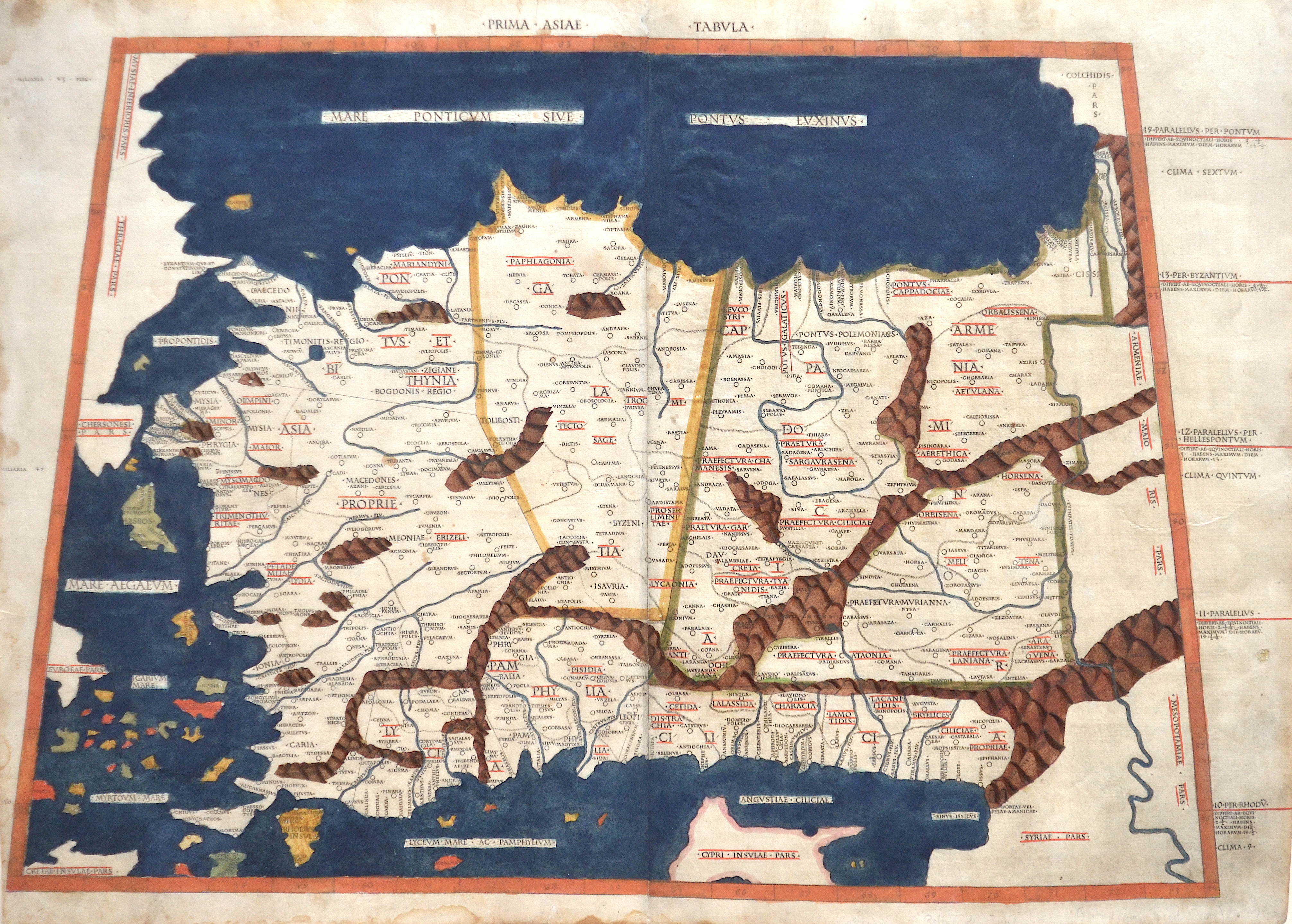
Prima Asiae Tabula

| Article ID | ASI0821 |
Title | Prima Asiae Tabula |
Description | Beautiful and very early map of Asia Minor, Turkey, Cyprus and neighbouring regions. Rivers and mountains are roughly shown in the country, on the frame side the climatically zones. Ptolomey watermark on the right side. |
| Year | ca. 1478 |
Artist | Ptolemy/Conrad Sweynheym |
Arnold Pannartz and Konrad Sweinheim were two printers of the 15th century. Pannartz died about 1476, Sweinheim in 1477. Pannartz was, perhaps, a native of Prague, and Sweinheim of Eltville near Mainz. Zedler believes (Gutenberg-Forschungen, 1901) that Sweinheim worked at Eltville with Gutenberg in 1461-1464. Whether Pannartz had been connected with Sweinheim in Germany is not known. It is certain that the two brought Gutenberg's invention to Italy. The Benedictine abbey of Subiaco was the cradle of Italian printing. Probably Cardinal Giovanni of Turrecremata, who was Abbot in commendam of Subiaco, summoned the two printers there. They came in 1464. The first book that they printed at Subiaco was a Donatus; it has not, however, been preserved. The first book printed in Italy that is extant was a Cicero, De oratore (now in the Buchgewerbehaus at Leipzig), issued in September, 1465. It was followed by Lactantius, De divinis institutionibus, in October, 1465, and Augustine's De civitate Dei (1467). These four impressions from Subiaco are of particular importance, because they abandon the Blackletter of the early German books. In Italy, Roman characters were demanded. Pannartz and Sweinheim, however, did not produce a pure but only a ""half Roman"" type with Blackletter-like characteristics. n 1467, the two printers left Subiaco and settled at Rome, where the brothers Pietro and Francesco Massimo placed a house at their disposal. The same year, they published an edition of Cicero's letters that gave its name to the cicero, the Continental equivalent of the pica. Their proof and manuscript reader was Giovan de' Bussi, since 1469 Bishop of Aleria in Corsica. In 1472, they applied to Pope Sixtus IV for Church benefices. From this we know that both were ecclesiastics: Pannartz of Cologne and Sweinheim of Mainz. The pope had a reversion drawn up for them, a proof of his great interest in printing. In 1474, Sweinheim was made a canon at St. Victor at Mainz. It is not known whether Pannartz also obtained benefice. Perhaps the pope also aided them, at any rate, they printed eighteen more works in 1472 and 1473. After this they separated. Pannartz printed by himself thirteen further volumes. Sweinheim took up engraving on metal and executed the fine maps for the Cosmography of Ptolemy (arround 100- 160 a.C.), the first work of this kind, but died before he had finished his task. Claudius Ptolemy Geographia, gives a list of geographic coordinates of spherical longitude and latitude of almost ten thousand point locations on the earth surface, as they were known at his times. The list is organized in Tabulae which cor- respond to specific regions of the three known continents at that time, Africa, Asia and Europe. Research on Ptolemy’s Geographia has started at the University of Thessaloniki, Greece, in the eighties, focused mainly, but not exclusively, on data re- lated to territories which are now under the sovereignty of the modern Greek state. The World of Ptolemy is classified in Regions, since each Chapter is referred to one of them, giving by this way the concept of Atlas as it is understood today. | |
Historical Description | The area of today's Turkey has been populated since the Paleolithic. The name of the Turks comes from Central Asia. The immigrants from whom Turkey got its name were the Oghusen and came from the area around the Aral Sea. The Turkish settlement of Anatolia began with the arrival of the Seljuks in the 11th century AD. Around 1299, Osman I, Gazi (1259–1326) founded the Ottoman dynasty named after him, from which the name of the Ottoman Empire (also called the Turkish Empire) ) derives. After the conquest of Constantinople in 1453, the Ottomans ruled over large parts of the Middle East, North Africa, the Crimea, the Caucasus and the Balkans. After the expansion of the Ottoman Empire into Europe was brought to a standstill near Vienna and the Ottoman army was defeated there on Kahlenberg in 1683, the empire was pushed back further and further from its European territories to the tip west of the Marmara Sea, between Istanbul and Edirne. The national movements that emerged from the 19th century onwards led to a gradual fragmentation of the empire, the occupation of Turkish North Africa by European powers and finally the defeat in the First World War resulted in its ultimate decline. |
| Place of Publication | Rome |
| Dimensions (cm) | 37 x 56 |
| Condition | Perfect condition, printed on two sheets and joined together |
| Coloring | original colored |
| Technique | Woodcut |
Reproduction:
1,125.00 €
( A reproduction can be ordered individually on request. )