

Adina Sommer
Antique and Contemporary Art
Winzerer Str. 154
80797 München
telephone
+49 89 304714
business hours:
by appointment
Email
![]()


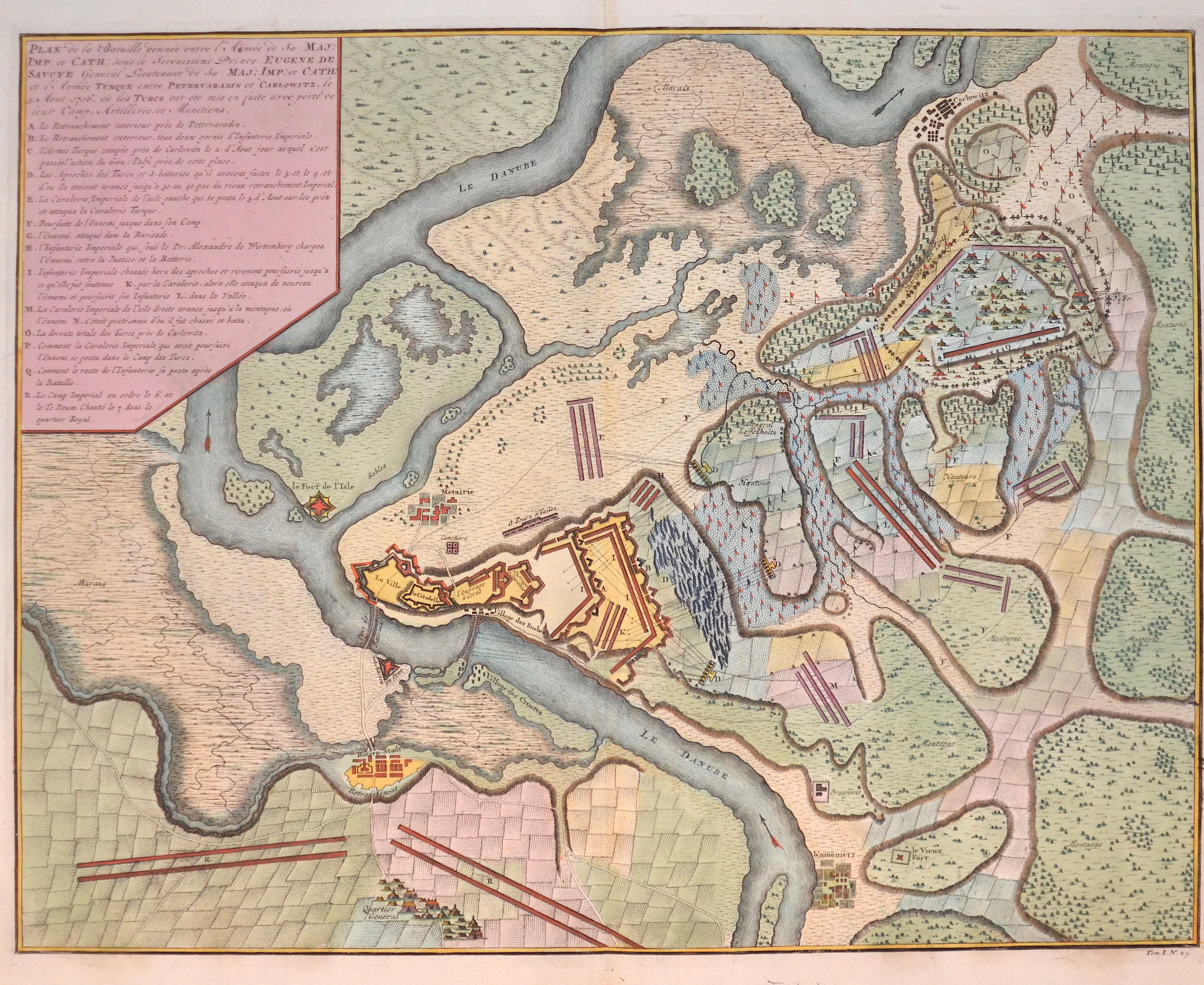
Plan de la battaille donnée entre l´armee de la maj.: Imp et Cath…..
| Article ID | EUH1372 |
Title | Plan de la battaille donnée entre l´armee de la maj.: Imp et Cath….. |
Description | Map shows the city of Peterwardein with the turkish army 1716. The Battle of Petrovaradin or Peterwardein was a decisive victory for the Imperial Army of the Holy Roman Emperor in the war between the Archduchy of Austria of the Holy Roman Empire and the Ottoman Empire (1716–1718). In 1716, Grand Vizier Damat Ali gathered a 150,000 strong Ottoman army at Belgrade. They crossed the Sava at Zemun at the end of July, and moved on the right bank of the Danube towards Sremski Karlovci (in the Habsburg territory). The Tatars, with Moldavians and Kurucs drove into Transylvania, but the Transylvanian forces were no match for the Tatars. The commander of the Austrian forces, Prince Eugene of Savoy, decided to engage the Ottomans at Petrovaradin. He had arranged for the construction of a fortified encampment within the Petrovaradin fortress there, and set the 83,300 strong Imperial army on the march from their quarters in Futog. On August 2, the first skirmish between the Imperial vanguard and Ottoman horsemen occurred. By the next day, the Grand Vizier had already reached Petrovaradin and immediately dispatched 30,000 Janissaries against the imperial positions. They dug saps and began to bombard the fortress. The core of the Imperial army only crossed the Danube on the night of August 5 by two pontoon bridges after which they encamped. |
| Year | ca. 1750 |
Artist | Anonymus |
Historical Description | The Kingdom of Hungary existed in changing borders from 1001 to 1918 and 1920 to 1946, originating in what is now western Hungary and subsequently expanding its domain to include the entire territory of present-day Hungary, as well as the territory of Transylvania, the Kreish and Maramures (both in the Romanian part of the Partium), Slovakia, Vojvodina, the Romanian part of the Banat, Carpatho-Ukraine, Burgenland, Prekmurje, Croatia (except Dalmatia and Istria) and some smaller territories. The first king of the kingdom was Stephen I the Saint from the ruling dynasty of the Árpáds, who was formally recognized as king of Hungary in 1001, when Pope Silvester II granted him the title of "Apostolic Majesty". In 1396, the Ottomans had to face a crusader army under the Hungarian king and later emperor Sigismund, which was crushingly defeated at the Battle of Nicopolis. The European powers, first and foremost the Holy Roman Empire, which had not considered the Ottomans as a serious threat for too long, were faced with the ruins of their policies concerning the Ottoman Empire at the latest with the fall of the medieval Kingdom of Hungary (1526). In the following decades, therefore, the only thing that mattered was to prevent, as far as possible, the further advance of the Ottomans towards Central Europe. In 1526 the decision in the fight against the Ottoman Empire followed in the Battle of Mohács. The Hungarian King Louis II fell in the battle. The following Hungarian Civil War, in which John I was supported by the Turks, ended in 1538 with the Peace of Grosswardein. John Zápolya and Ferdinand were both allowed to continue to use the Hungarian royal title and to rule a part of Hungary. To forestall Habsburg claims, Suleyman I intervened and occupied Buda and central Hungary. Hungary was divided into three parts after 1540 according to the power relations created. The exact demarcation of the borders between the individual parts varied considerably. After the Habsburgs and their allies had pushed the Ottoman Empire back to the territories south of the Danube and the Sava and fixed this in the Peace of Karlowitz in 1699, the Kingdom of Hungary, which had never disappeared de jure, was also restored de facto. The k.u.k. Monarchy existed until its defeat in World War I, when Hungary denounced the Real Union as of October 31, 1918. A short time later, the Hungarian Republic was proclaimed. The kingdom was under several foreign dominations in its history and regained its sovereignty in 1867 as a federal (partial) state of Austria-Hungary. |
| Dimensions (cm) | 44,5 x 57 |
| Condition | Very good |
| Coloring | original colored |
| Technique | Copper print |
Reproduction:
52.50 €
( A reproduction can be ordered individually on request. )