

Adina Sommer
Antique and Contemporary Art
Winzerer Str. 154
80797 München
telephone
+49 89 304714
business hours:
by appointment
Email
![]()


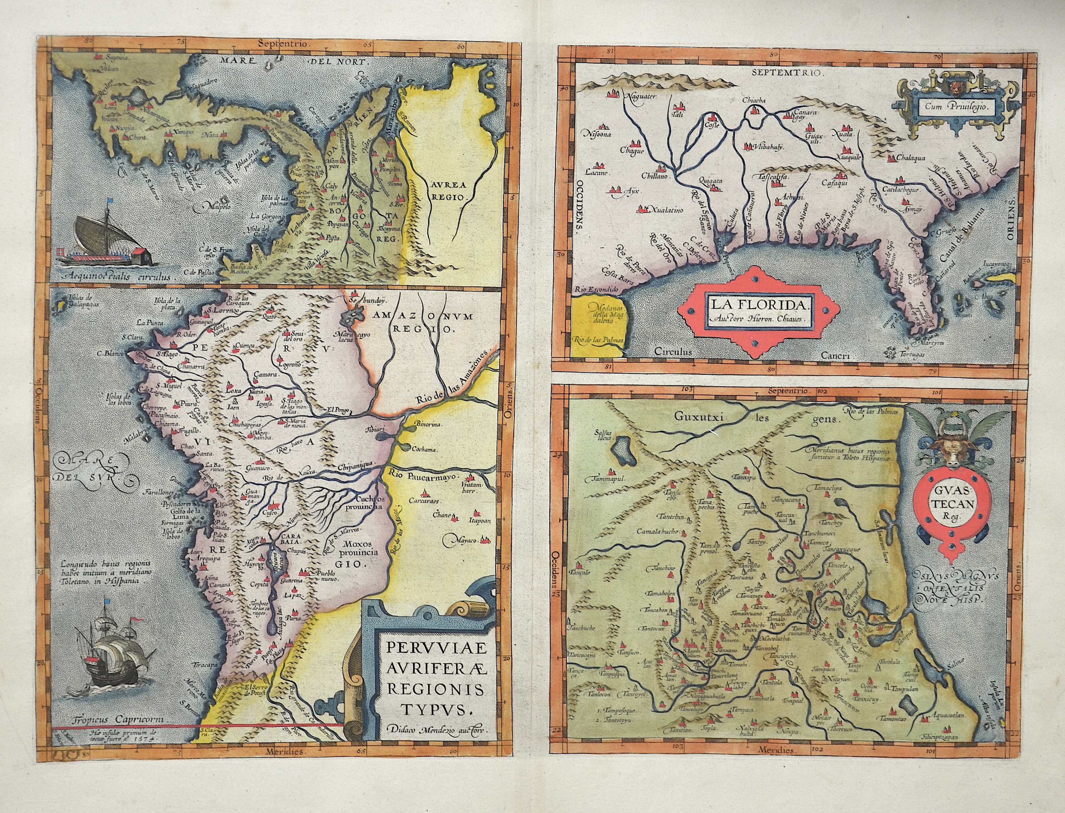
Peruiae”, “La Florida” & “Guastecan
| Article ID | AMZ182 |
Title | Peruiae”, “La Florida” & “Guastecan |
Description | map of Peru, Florida and the eastern coast of Mexico around Tampica, 3 maps at one sheet |
| Year | ca. 1570 |
Artist | Ortelius (1527-1598) |
Abraham Ortelius, (1527 - 1598) Antwerp, comes from an Augsburg family and was born in Antwerp, Spain, where he lived throughout his life. After thorough training, he joined the Antwerp Guild of St. Luke in 1547 as a card painter. In 1554 he took over an antiquarian bookshop that mainly deals with the coloring, distribution and publishing of maps. Basically he is more of a publisher than a scholar. And so he also made the acquaintance of another great man of his time, Gerhard Mercator (1512-1594), who encouraged him to draw cards and to make maps of the most varied of countries. His first cartographic work of his own is a large 8-sheet map of the world that appears in Antwerp in 1564. This is followed by a two-sheet map of Egypt (1565) and another of Asia (1567). The great achievement of Ortelius, who was one of the most famous European cartographers of his time, and the enthusiastic reception of his theater, mark a decisive turning point in the history of the world map. The new path is mapped out with the Theatrum. For the general view of the world, the appearance of Ortelius-Theatrum is important insofar as it emphatically confirms that America is a completely independent continent, which is also not connected to the Asian mainland mass at its northern tip. Ortelius was the first to come up with the idea of producing a handy collection of reliable maps, all kept in the same format and only by the same author for each country. These sheets could also be bound into a book for easy storage and use. Mercator, who also realized the idea of a world atlas from 1569, persuaded his friend to publish the famous Theatrum Orbis Terrarrum. Ortelius collected, traveled, corresponded and negotiated for 10 years before he could have his work printed in the best European printing house (Plantijn / Amsterdam). In addition to technical difficulties, Ortelius had to submit to the political / religious conditions, since maps were also subject to strict scrutiny during the Inquisition. Biblical scenes are pleasant, portraits of outstanding Catholics are welcome, but not family coats of arms or other emblems that could be politically suspect. On May 20, 1570, his first edition of the Theatrum Orbis Terrarum, the first collection of maps in book form, was published, financed and edited by Gillis Hooftman, an Antwerp merchant, banker and shipowner. Atlases did not yet have this name at that time. This collection was published between 1570 and 1612 in 42 editions and in 7 languages: Latin, German, Dutch, French, Spanish, English and Italian. Unlike his professional colleagues, he clearly referenced the sources of his maps and texts. The work contains, among other things, an illustration of the world known until 1492 and was therefore already looking back at the time the map was created. | |
Historical Description | Central America includes Central America and the West Indies. On the land bridge, in addition to various indigenous languages, mainly Spanish is spoken due to the colonization. Exceptions are the English-speaking Belize and the east coast of Nicaragua, which is inhabited by English-speaking Creoles in addition to the indigenous peoples Miskito, Mayangna, Rama and Garifuna. There are also communities on the Caribbean coast of Guatemala, Honduras, Costa Rica and Panama in which mainly Creole English, similar to the Jamaican patois, is spoken. When Columbus landed on San Salvador (Bahamas) on behalf of the Spanish crown in 1492, he was primarily looking for gold and other riches. But the Arawak paid no attention to what Europeans viewed as wealth. So the Caribbean was settled, but the conquistadors were soon drawn to the American continent. Little by little the English, Dutch and French also settled. Even Denmark, Sweden and Courland owned a few colonies. St. Barthélemy was z. B. almost a century under Swedish rule. Most of the native Indians eventually fell victim to diseases or slavery that were brought in. The Caribbean was particularly active in the 17th and early 18th centuries for buccaneers and pirates (so-called golden age of piracy). The small islands offered the pirates, some of whom were freebooters on behalf of a king, numerous hiding places and the Spanish treasure fleets were a good and worthwhile target. Port Royal in Jamaica and the French settlement on Tortuga were downright pirate settlements. |
| Place of Publication | Antwerp |
| Dimensions (cm) | 33,5 x 46,5 |
| Condition | Very good |
| Coloring | colored |
| Technique | Copper print |
Reproduction:
315.00 €
( A reproduction can be ordered individually on request. )