

Adina Sommer
Antique and Contemporary Art
Winzerer Str. 154
80797 München
telephone
+49 89 304714
business hours:
by appointment
Email
![]()


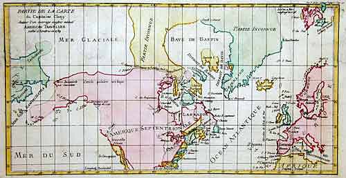
Partie de la Carte du Capitaine Cluny…
| Article ID | AMN091 |
Title | Partie de la Carte du Capitaine Cluny… |
Description | Map of North America with Greenland. |
| Year | dated 1769 |
Artist | Vaugondy,de (1723-1786) |
Didier Robert de Vaugondy (1723 -1786) also known as Le Sieur or Monsieur Robert, and his son, were leading cartographers in France during the 18th century. In 1757, Gilles and Didier Robert De Vaugondy published The Atlas Universel, one of the most important atlases of the 18th century. To produce the atlas, the Vaugondys integrated older sources with more modern surveyed maps. They verified and corrected the latitude and longitude of many regional maps in the atlas with astronomical observations. The older material was revised with the addition of many new place names. In 1760, Didier Robert de Vaugondy was appointed geographer to Louis XV. Gilles and Didier Robert De Vaugondy produced their maps and terrestrial globes working together as father and son. Globes of a variety of sizes were made by gluing copperplate-printed gores on a plaster-finished papier-mache core, a complicated and expensive manufacturing process, employing several specialists. In some cases it is uncertain whether Gilles or Didier made a given map. Gilles often signed maps as M.Robert, while Didier commonly signed his maps as ""Robert de Vaugondy"", or added ""fils"" or ""filio"" after his name. The Robert de Vaugondys were descended from the Nicolas Sanson family through Sanson's grandson, Pierre Moulard-Sanson. From him, they inherited much of Sanson's cartographic material, which they combined with maps and plates acquired after Hubert Jaillot's death in 1712 to form the basis the Atlas Universel. | |
Historical Description | The discovery of America means the first sighting of the American continent by seafarers. Before Columbus' arrival in 1492, North America may have had more inhabitants than Europe at that time. In 1497 the Genoese John Cabot (actually: Giovanni Caboto) became the first European since the Vikings to set foot on North American soil. However, permanent branches were not established for the time being. St. Augustine in Florida, founded in 1565 by the Spanish, is considered the first city on mainland North America, and is also the oldest city in the USA. Four states stood out in the European conquest of North America, each of which made it easier to take possession: England was under pressure to emigrate, also based on religion, and was thus able to represent the largest group in terms of numbers. France had special skills in dealing with the indigenous peoples, which later led to the only mixed ethnic group, the Métis, and the Netherlands had the financial means to establish colonies in North America. Spain had enormous military potential due to the combat experience. In 1604 the King of England Jacob I divided his North American colonies as follows: The area from the 1st to the 41st degree of latitude is said to be populated by the Virginia Company of London, the area from the 41st to the 45th degree the Plymouth Company. 1607 is considered the year of foundation of the first permanent colony of English settlers on the east coast of America. There was a collision between three cultures: Native Americans, white settlers and slaves from Africa. This year the first settlers from England landed in Jamestown, followed in 1620 by the (better known) pilgrims with the Mayflower in what is now the US state of Massachusetts. These could find shelter directly in the abandoned Indian settlements. The coastal Indians were now ready to cooperate and had Plymouth established the English gateway to North America. |
| Place of Publication | Paris |
| Dimensions (cm) | 29 x 49 |
| Condition | Very good |
| Coloring | colored |
| Technique | Copper print |
Reproduction:
55.50 €
( A reproduction can be ordered individually on request. )