

Adina Sommer
Antique and Contemporary Art
Winzerer Str. 154
80797 München
telephone
+49 89 304714
business hours:
by appointment
Email
![]()


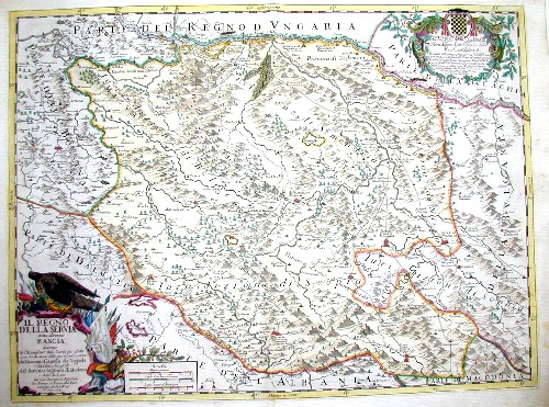
Il regno della Servia detta altrimenti rascia

| Article ID | EUY644 |
Title | Il regno della Servia detta altrimenti rascia |
Description | Map shows Serbia |
| Year | dated 1689 |
Artist | Cantelli da Vignola (1643-1695) |
Giacomo Cantelli da Vignola (1643 - 1695) was an important Italian cartographer and engraver Cantelli was born in Montorsello, near Vignola Italy to a prominent local family. After studying literature at the University of Bologna, Cantelli took a position as secretary to the Marquis Obizzi de Ferrara. Eventually Cantelli relocated to Venice where developed an interest in cartography. He later traveled to Paris in the company of the French ambassador where became acquainted with the French cartographer Guillaume Sanson, as well as his contemporaries Jacques-Andre Duval and Michel-Antoin Baudrand. It was most likely the influence of these innovative French cartographers that inspired Cantelli's careful and meticulous approach, in which he based his cartography not just on earlier maps, but also very much in the French style upon accounts written by travelers and merchants regarding actual travel to foreign lands. Back in Italy, Cantelli took service Count Rinieri Marescotti, with whom he traveled extensively throughout Italy, becoming in the process acquainted with the Italian publisher Giovanni Giacomo de Rossi. It is with Rossi that Cantelli began officially publishing his maps. The earliest maps to bear the Cantelli-Rossi imprint date to 1672 and detail the Holy Land, Persia, and the Ottoman Empire. Around 1680 the duo also began to publish the Mercurio Geografico, a large format atlas illustrating all parts of the world in a splendid Italian baroque detail defined by elaborate finely engraved cartouche work, high quality paper, and bold Roman lettering, and dark rich inks. Some have compared his style go that of Giovanni Antonio Magini, another Italian cartographer of the previous generation. Cantelli da Vignola in fact pioneered the Italian style of fine bold engraving that would eventually be embraced and expanded upon by Vincenzo Coronelli. His work drew the attention of Pope Innocent XI and Reggio Francesco II d'Este, the Duke of Modena, both of whom offered him a position as court geographer. Cantelli chose to work with the Due of Modena, in the service of whom he produced numerous maps and well as two large globes. | |
Historical Description | In all Serbian lands conquered by the Ottomans, the native nobility was eliminated and the peasantry was enserfed to Ottoman rulers, while much of the clergy fled or were confined to the isolated monasteries. Under the Ottoman system, Serbs, as well as Christians, were considered an inferior class of people and subjected to heavy taxes, and a portion of the Serbian population experienced Islamization. After the loss of statehood to the Ottoman Empire, Serbian resistance continued in northern regions (modern Vojvodina), under titular despots (until 1537), and popular leaders like Jovan Nenad (1526–1527). From 1521 to 1552, Ottomans conquered Belgrade and regions of Syrmia, Bačka, and Banat. One of the most significant was the Banat Uprising in 1594 and 1595, which was part of the Long War (1593–1606) between the Habsburgs and the Ottomans. As the Great Serb Migrations depopulated most of southern Serbia, the Serbs sought refuge across the Danube River in Vojvodina to the north and the Military Frontier in the west, where they were granted rights by the Austrian crown under measures such as the Statuta Wallachorum of 1630. Much of central Serbia switched from Ottoman rule to Habsburg control (1686–91) during the Habsburg-Ottoman war (1683-1699). In 1718–39, the Habsburg Monarchy occupied much of Central Serbia and established the Kingdom of Serbia as crownland. Those gains were lost by the Treaty of Belgrade in 1739, when the Ottomans retook the region. |
| Place of Publication | Modena |
| Dimensions (cm) | 41 x 55 |
| Condition | Very good |
| Coloring | colored |
| Technique | Copper print |
Reproduction:
75.00 €
( A reproduction can be ordered individually on request. )