

Adina Sommer
Antique and Contemporary Art
Winzerer Str. 154
80797 München
telephone
+49 89 304714
business hours:
by appointment
Email
![]()


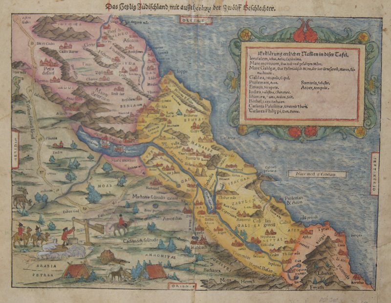
Das heylig jüdisch Land mit auszcheilung der zwölf Geschlechter
| Article ID | ASP318 |
Title | Das heylig jüdisch Land mit auszcheilung der zwölf Geschlechter |
Description | Map shows the Holy Land with scenes representations. |
| Year | ca. 1550 |
Artist | Münster (1489-1552) |
Sebastian Münsters (1489-1552) is one of the famous cosmographers of the Renaissance. Its real importance in the field of cartography is based on its famous cosmography, which he published in 1544 with 24 double-sided maps (including Moscow and Transylvania). The material for this came largely from research and the collection of information from around 1528, which he initially only wanted to use for a description of Germany, but was now sufficient for a map of the entire world and ultimately led to a cosmography. He constantly tried to improve this work, i.e. to replace or add to maps. In the edition of 1550, only 14 maps were taken over from the earlier editions. The 52 maps printed in the text were also only partially based on the old maps. The great success of this cosmography was also based on the precise work of the woodcuts mostly by Hans Holbein the Younger, Urs Graf, Hans Rudolph Deutsch and David Kandel. It was the first scientific and at the same time generally understandable description of the knowledge of the world in German, in which the basics of history and geography, astronomy and natural sciences, regional and folklore were summarized according to the state of knowledge at that time. Cosmography is the science of describing the earth and the universe. Until the late Middle Ages, geography, geology and astronomy were also part of it. The first edition of the Cosmographia took place in 1544 in German, printed in Heinrich Petri's office in Basel. Heinrich Petri was a son from the first marriage of Münster's wife to the Basel printer Adam Petri. Over half of all editions up to 1628 were also published in German. However, the work has also been published in Latin, French, Czech and Italian. The English editions all comprised only a part of the complete work. Viktor Hantzsch identified a total of 46 editions in 1898 (German 27; Latin 8; French 3; Italian 3; Czech 1) that appeared from 1544 to 1650, while Karl Heinz Burmeister only had 36 (German 21; Latin 5; French 6; Italian 3; Czech 1) that appeared between 1544 and 1628. The first edition from 1544 was followed by the second edition in 1545, the third in 1546, the fourth edition in 1548 and the fifth edition in 1550, each supplemented by new reports and details, text images, city views and maps and revised altogether. Little has been known about who - apart from the book printers Heinrich Petri and Sebastian Henricpetri - were responsible for the new editions after Münster's death. The 1628 edition was edited and expanded by the Basel theologian Wolfgang Meyer. With Cosmographia, Sebastian Münster has published for the first time a joint work by learned historians and artists, by publishers, wood cutters and engravers. The numerous vedute are usually made as woodcuts. Sebastian Münster obtained his knowledge from the travel reports and stories of various scholars, geographers, cartographers and sea travelers. Long after his death, "Kosmographie" was still a popular work with large editions: 27 German, 8 Latin, 3 French, 4 English and even 1 Czech editions appeared. The last edition appeared in Basel in 1650. | |
Historical Description | One of the oldest cities in the world, Jerusalem was named as "Urusalima" on ancient Mesopotamian cuneiform tablets, probably meaning "City of Shalem". During its long history, Jerusalem has been destroyed at least twice. The part of Jerusalem called the City of David was settled in the 4th millennium BCEIn 1538, walls were built around Jerusalem under Suleiman the Magnificent. Today those walls define the Old City, which has been traditionally divided into four quarter. There is no evidence of a permanent settlement in the City of David area until the early Bronze Age . Many Jewish tombs from the Second Temple period have been rediscovered in Jerusalem. One example, discovered north of the Old City, contains human remains in an ossuary decorated with the Aramaic inscription "Simon the Temple Builder. In 1517, Jerusalem and environs fell to the Ottoman Turks, who generally remained in control until 1917 .Jerusalem enjoyed a prosperous period of renewal and peace under Suleiman the Magnificent – including the rebuilding of magnificent walls around the Old City. Throughout much of Ottoman rule, Jerusalem remained a provincial, if religiously important center, and did not straddle the main trade route between Damascus and Cairo. The English reference book Modern history or the present state of all nations, written in 1744, stated that "Jerusalem is still reckoned the capital city of Palestine, though much fallen from its ancient grandeaur". The Ottomans brought many innovations: modern postal systems run by the various consulates and regular stagecoach and carriage services were among the first signs of modernization in the city. In the mid 19th century, the Ottomans constructed the first paved road from Jaffa to Jerusalem, and by 1892 the railroad had reached the city. |
| Place of Publication | Basle |
| Dimensions (cm) | 27 x 35 |
| Condition | Minor restorations |
| Coloring | original colored |
| Technique | Wood engraving |
Reproduction:
97.50 €
( A reproduction can be ordered individually on request. )