

Adina Sommer
Antique and Contemporary Art
Winzerer Str. 154
80797 München
telephone
+49 89 304714
business hours:
by appointment
Email
![]()


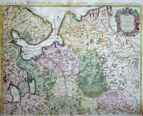
Carte de Moscovie Dresse par G.de L´ Isle

| Article ID | EUO1654 |
Title | Carte de Moscovie Dresse par G.de L´ Isle |
Description | Map shows the north west part of Russi and partly Lappland |
| Year | ca. 1730 |
Artist | Covens/ Mortier (1685-1740) |
Jean Covens und Corneille Mortier where brothers in law, who continued the bussines, founded of Pierre Mortier in 1685 in Amsterdam. They called it Covens & Mortier. They extended their buissines in buying the company of De Witt. | |
Historical Description | The region lies in the fertile basin of the Volga, Oka, Kljasma and Moskva rivers. In the north and west of the oblast lies the Moscow Ridge, which reaches up to 310 m in height with the Klin-Dmitrov Ridge. To the east and southeast is the Meshchora lowland. In the southwest lies the Central Russian Plate. In the middle of the 12th century, the territory of today's Moscow Oblast was annexed to the Principality of Vladimir-Suzdal. At the same time, cities such as Volokolamsk, Moscow, Svenigorod, Dmitrov were founded. From 1708, the area belonged to the Moscow governorate founded by Peter I. From the 18th to the 19th century, light industry, especially the textile industry, experienced a boom. Its important centres were Bogorodsk, Pavlovsky Possad and Orechovo-Suyevo. In 1851, the first railway line was laid on the territory of the Moscow governorate, connecting Moscow with St. Petersburg. Several times, new oblasts were formed from parts of the Moscow Oblast: Kalinin Oblast in 1935, Ryazan Oblast and Tula Oblast in 1937, Kaluga Oblast in 1944 and Vladimir Oblast in 1944. |
| Place of Publication | Amsterdam |
| Dimensions (cm) | 49 x 61,5 |
| Condition | Upper part of two sheets, upper centerfold perfectly restored |
| Coloring | original colored |
| Technique | Copper print |
Reproduction:
90.00 €
( A reproduction can be ordered individually on request. )