

Adina Sommer
Antique and Contemporary Art
Winzerer Str. 154
80797 München
telephone
+49 89 304714
business hours:
by appointment
Email
![]()


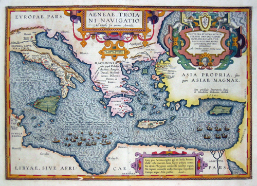
Aeneae Trioani Navigatio ad Virgisij sex priores Aeneidos

| Article ID | EUM2178 |
Title | Aeneae Trioani Navigatio ad Virgisij sex priores Aeneidos |
Description | Map shows the eastern Mediterranean sea with Sicily, Greece, Kreta and Cyprus. With 3 beautyfull and splendid cartouches. |
| Year | ca. 1612 |
Artist | Ortelius (1527-1598) |
Abraham Ortelius, (1527 - 1598) Antwerp, comes from an Augsburg family and was born in Antwerp, Spain, where he lived throughout his life. After thorough training, he joined the Antwerp Guild of St. Luke in 1547 as a card painter. In 1554 he took over an antiquarian bookshop that mainly deals with the coloring, distribution and publishing of maps. Basically he is more of a publisher than a scholar. And so he also made the acquaintance of another great man of his time, Gerhard Mercator (1512-1594), who encouraged him to draw cards and to make maps of the most varied of countries. His first cartographic work of his own is a large 8-sheet map of the world that appears in Antwerp in 1564. This is followed by a two-sheet map of Egypt (1565) and another of Asia (1567). The great achievement of Ortelius, who was one of the most famous European cartographers of his time, and the enthusiastic reception of his theater, mark a decisive turning point in the history of the world map. The new path is mapped out with the Theatrum. For the general view of the world, the appearance of Ortelius-Theatrum is important insofar as it emphatically confirms that America is a completely independent continent, which is also not connected to the Asian mainland mass at its northern tip. Ortelius was the first to come up with the idea of producing a handy collection of reliable maps, all kept in the same format and only by the same author for each country. These sheets could also be bound into a book for easy storage and use. Mercator, who also realized the idea of a world atlas from 1569, persuaded his friend to publish the famous Theatrum Orbis Terrarrum. Ortelius collected, traveled, corresponded and negotiated for 10 years before he could have his work printed in the best European printing house (Plantijn / Amsterdam). In addition to technical difficulties, Ortelius had to submit to the political / religious conditions, since maps were also subject to strict scrutiny during the Inquisition. Biblical scenes are pleasant, portraits of outstanding Catholics are welcome, but not family coats of arms or other emblems that could be politically suspect. On May 20, 1570, his first edition of the Theatrum Orbis Terrarum, the first collection of maps in book form, was published, financed and edited by Gillis Hooftman, an Antwerp merchant, banker and shipowner. Atlases did not yet have this name at that time. This collection was published between 1570 and 1612 in 42 editions and in 7 languages: Latin, German, Dutch, French, Spanish, English and Italian. Unlike his professional colleagues, he clearly referenced the sources of his maps and texts. The work contains, among other things, an illustration of the world known until 1492 and was therefore already looking back at the time the map was created. | |
Historical Description | Numerous paleoanthropological finds, for example from the Arago cave near Perpignan, prove that Homo erectus already lived in the Mediterranean. In the period of several hundred thousand years, the polar ice caps repeatedly expanded, glaciers covered the high mountains during the ice ages. The sea level was therefore temporarily up to 150 meters below today's level. The Strait of Gibraltar temporarily closed. The Stone Age replaced the Stone Age in different regions. Copper spreads first, then bronze. Spain, rich in metals, began around 2300 BC. The Bronze Age (El Argar culture). Numerous fortified settlements were created. The first states emerged with the Pharaoh dynasties around 3000 BC. BC in Egypt. Almost simultaneously, the first city-states were formed on the Levant and Aegean coasts. The great empires of the early days of Assyria, Babylonia and the Hittites - temporarily expanded into the Mediterranean area. Since the archaic period, i.e. from 800 BC BC, ancient Greece also emerged as a trading power and increasingly created competition for the Phoenicians. The Greeks settled as far as the Rhône (Massilia) and the Crimea and set up offices and factories as far as Egypt. Tuscany was the settlement area of the Etruscans, who also controlled the rich iron deposits of Elba. This culture developed from the local Villanova culture, later under strong Greek and Syrian ("oriental") influence. In Rome, the founding of Rome began with the slow but steady rise of the Romans, which began around 500 BC. BC finally emancipated from the Etruscans and founded the republic. The south of the Apennine Peninsula was characterized by the Greek colonies ("Magna Graecia"). At the same time, the Persian empire extended to Egypt and the Bosphorus, subjugating the Phoenicians and the Egyptians. The period of great Persian expansion coincided with the blossoming of Greece, which was able to ward off the Persian invasions in several battles. While the Greeks colonized large parts of the northern Mediterranean coast, the Phoenicians - after (Tire) had lost their independence - built Carthage in North Africa as a new power base and also established commercial branches in Spain (Cadiz), Morocco, Corsica and Sardinia. Sicily was contested between the great powers at that time because of its rich resources and location. In late antiquity, the slow Christianization of the Roman state began, which should have far-reaching consequences, such as the rejection of paganism. The late Middle Ages were characterized by a sustained upswing in the Italian area. Especially the Republic of Venice. The most important naval powers of the early modern period continued to be Venice and Genoa, which dominated trade with the Arab world and thus to Southeast Asia. They also had numerous colonies in the eastern Mediterranean. The War of the Spanish Succession brought about a reorganization of the western and central Mediterranean region in 1713. The French expansion was initially stopped, Spain was reduced to the mainland and the Balearic Islands and the Italian area was redistributed among the rulers. The winner was above all the Habsburg-Austrian line, which also won southern Italy, Sicily, Sardinia and Milan. However, this situation did not last long: the Spanish-Bourbon royal family soon regained control of the Italian territory. Most of the Maghreb were now ruled by Berber tribes, which were beyond the control of the Ottoman Empire but neglected the economy. Morocco and Algeria were marginalized economically, which invited the Spaniards to invasions. The Ceuta and Melilla bases are still under Spanish control. |
| Place of Publication | Antwerp |
| Dimensions (cm) | 34,5 x 49 cm |
| Condition | Very good |
| Coloring | original colored |
| Technique | Copper print |
Reproduction:
240.00 €
( A reproduction can be ordered individually on request. )