

Adina Sommer
Antique and Contemporary Art
Winzerer Str. 154
80797 München
telephone
+49 89 304714
business hours:
by appointment
Email
![]()


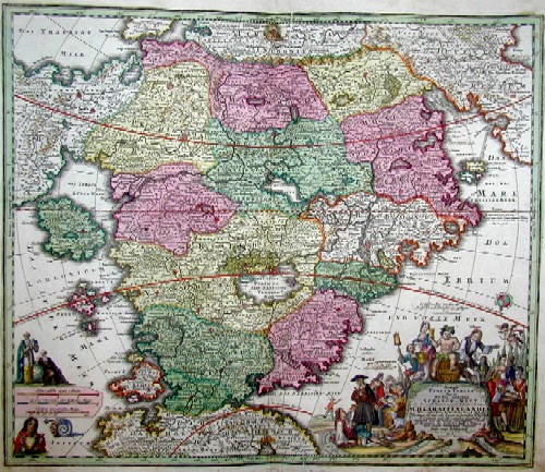
Accurata Utopia Tabula….Schalck Welt oder des so offt benannten und doch nie erkannten Schlaraffenlandes neu erfundene lächerliche Landtabelle
| Article ID | DO0238 |
Title | Accurata Utopia Tabula….Schalck Welt oder des so offt benannten und doch nie erkannten Schlaraffenlandes neu erfundene lächerliche Landtabelle |
Description | Map shows the- Paradise -with descriptions of the sweet life of eating, drinking, sleeping, celebrating ect.It appears for the first time in the Atlas novus terrarum (Nuremberg, 1716); previously it cannot be detected. The starting point for this map was a book by the imperial general Johann Andreas Schnebelin; explanation of the wonder-strange country charts Utopiae, so there is, the newly discovered land of milk and honey; who in turn used a book idea by the English bishop Joseph Hall (early 17th century). The map of the land of milk and honey shows us 17 provinces and some island groups that represent (many) vices and (few) virtues. |
| Year | ca. 1710 |
Artist | Homann (1664-1724) |
Johann Babtiste Homann (1664-1724), Nuremberg, was born in Oberkammlach, the Electorate of Bavaria. Although educated at a Jesuit school, and preparing for an ecclesiastical career, he eventually converted to Protestantism and from 1687 worked as a civil law notary in Nuremberg. He soon turned to engraving and cartography; in 1702 he founded his own publishing house. Homann acquired renown as a leading German cartographer, and in 1715 was appointed Imperial Geographer by Emperor Charles VI. Giving such privileges to individuals was an added right that the Holy Roman Emperor enjoyed. In the same year he was also named a member of the Prussian Academy of Sciences in Berlin. Of particular significance to cartography were the imperial printing privileges (Latin: privilegia impressoria). These protected for a time the authors in all scientific fields such as printers, copper engravers, map makers and publishers. They were also very important as a recommendation for potential customers. In 1716 Homann published his masterpiece Grosser Atlas ueber die ganze Welt (Grand Atlas of all the World). Numerous maps were drawn up in cooperation with the engraver Christoph Weigel the Elder, who also published Siebmachers Wappenbuch. Homann died in Nuremberg. He was succeeded by the Homann heirs company, which was in business until 1848. The company was known as Homann Erben, Homanniani Heredes, or Heritiers de Homann abroad. | |
| Place of Publication | Nuremberg |
| Dimensions (cm) | 49,5 x 57,5 |
| Condition | Very good |
| Coloring | original colored |
| Technique | Copper print |
Reproduction:
300.00 €
( A reproduction can be ordered individually on request. )