

Adina Sommer
Antique and Contemporary Art
Winzerer Str. 154
80797 München
telephone
+49 89 304714
business hours:
by appointment
Email
![]()


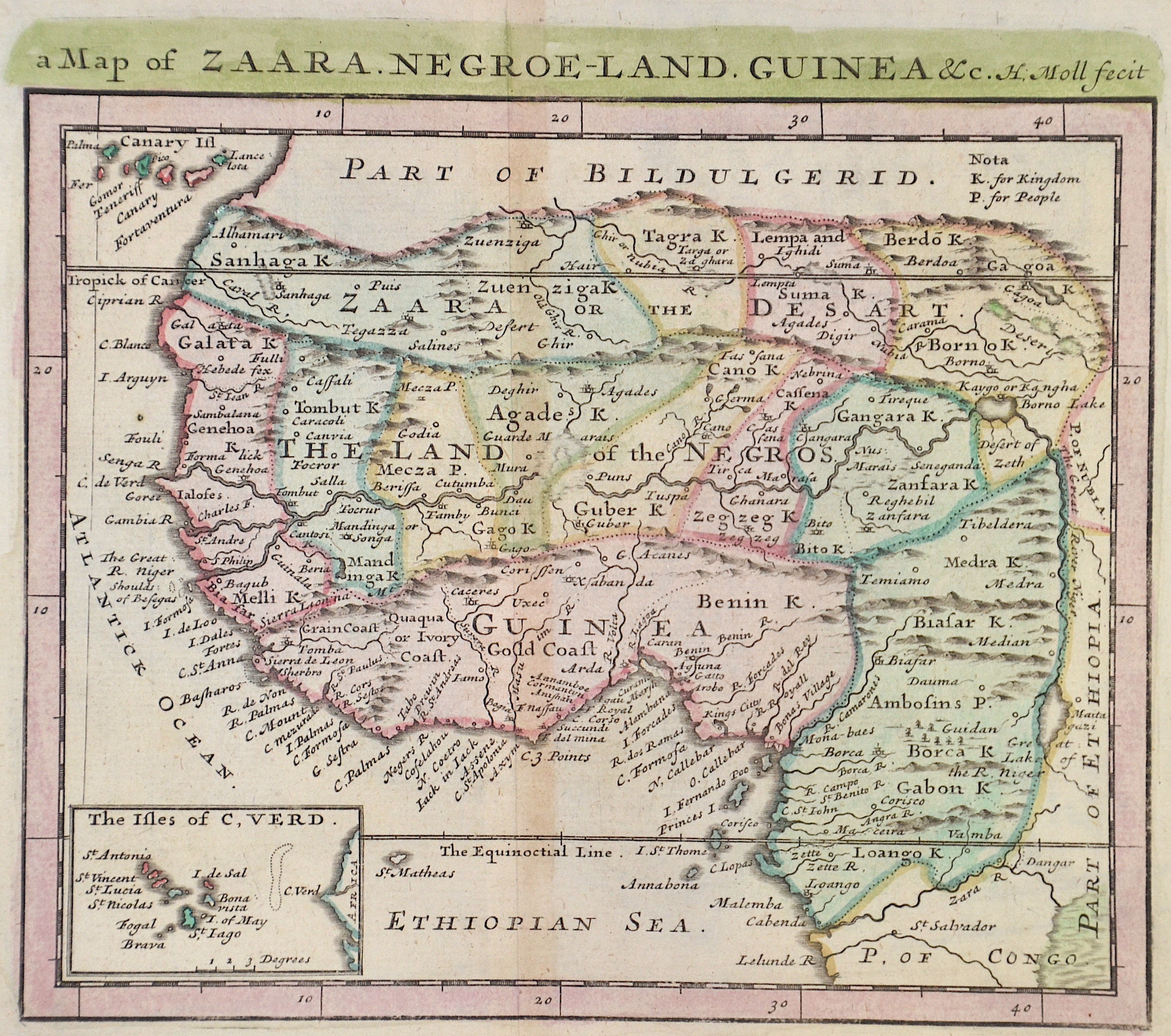
A Map of Zaara. Negroe-Land. Guinea

| Article ID | AF0531 |
Title | A Map of Zaara. Negroe-Land. Guinea |
Description | Map shows the region of West Africa and a partial map with Cape Verde. At that time, this region in West Africa was called Nigrites (English Negroland, French Nigritie, Latin Nigritia). Of the western part of Africa, the coastal regions had been explored somewhat more thoroughly, while little was known about the interior. Thus Negroe Land corresponds to the imagination of European cartographers. |
| Year | ca. 1719 |
Artist | Moll (1654-1732) |
Hermann Moll (1654- 1732) London was a cartographer, engraver, and publisher. Moll produced his earliest maps from studying cartographers such as John Senex and Emanuel Bowen. In the 1690s, Moll worked mainly as an engraver for Christopher Browne, Robert Morden and Lea, in whose business he was also involved. During this time he also published his first major independent work, the Thesaurus Geographicus. The success of this work likely influenced his decision to start publishing his own maps. For the production of his maps Moll relied on the most accurate geographical information possible from first hand. Moll benefited from his acquaintance with circumnavigator and privateer William Dampier, who returned to London in 1691 from his first circumnavigation of the world. Dampier wrote a report about the experiences of his twelve-year trip, which appeared in London in 1698 and had its fourth edition just a year later. Moll produced most of the maps and illustrations for the story, which was titled A New Voyage round the World. While Moll's cartographic material increased the clarity of Dampier's descriptions for the reader enormously, Dampier's geographical knowledge was extremely important for the accuracy of Moll's maps. At a time when cartographers relied on the local knowledge of merchants and captains, the acquaintance of a man like Dampier was decisive for the economic success of a cartographer like Moll. The growing public interest in travel literature and the enormous success of Dampier in turn stimulated other authors such as Daniel Defoe or Jonathan Swift to write similar works. They too would later fall back on Moll's artistic abilities to illustrate their works. | |
Historical Description | According to the "Out-of-Africa theory", Africa is considered the "cradle of mankind", where homo development led to the development of the anatomically modern human Homo sapiens. One of the earliest advanced civilizations in mankind was formed in ancient Egypt. Over the millennia, various "great empires" such as the Empire of Abyssinia emerged on the continent. There were other kingdoms in West Africa, such as the Ashanti and Haussa, but they emerged much later. There were also some important cultures in East and South Africa, as in the area of today's Sudan, then called Nubia or Kush. Nubian pharaohs ruled all of Egypt for a dynasty. For example, the inhabitants of Greater Zimbabwe were important cultures in southern Africa. This stone castle was architecturally a masterpiece at that time and important for trade between the peoples of the south and east. The Swahili were known in East Africa. North Africa was connected to Europe and the Near East by the Mediterranean rather than separated. Carthage, a foundation of the Phoenicians in what is now Tunisia, was around the middle of the 1st millennium BC. The dominant power in the western Mediterranean until it was replaced by Rome in the Punic Wars. This prevailed from 30 BC. BC (conquest of Egypt) over all of North Africa. Even the ancient Egyptians (Queen Hatshepsut) made trips to Punt, probably in what is now Somalia. The kingdom of the Queen of Sheba, which probably had its center in southern Arabia, is said to have spanned parts of the Horn from Africa to the north of Ethiopia. |
| Place of Publication | Paris |
| Dimensions (cm) | 17 x 19,5 cm |
| Condition | Perfect condition |
| Coloring | colored |
| Technique | Copper print |
Reproduction:
13.50 €
( A reproduction can be ordered individually on request. )