

Adina Sommer
Antique and Contemporary Art
Winzerer Str. 154
80797 München
telephone
+49 89 304714
business hours:
by appointment
Email
![]()


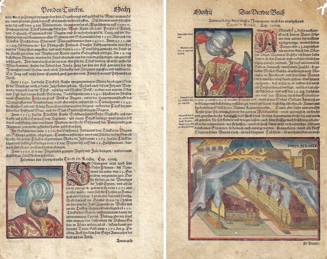
Von den Türcken. / Zelymus der dreyzehndt Türckisch Keyser.
| Article ID | AST1259 |
Title | Von den Türcken. / Zelymus der dreyzehndt Türckisch Keyser. |
Description | Description of the Turks. Front shows the 13th emperor Zelymus arround 1571. On reverse the turkish emperor Amurath. |
| Year | ca. 1580 |
Artist | Münster (1489-1552) |
Sebastian Münsters (1489-1552) is one of the famous cosmographers of the Renaissance. Its real importance in the field of cartography is based on its famous cosmography, which he published in 1544 with 24 double-sided maps (including Moscow and Transylvania). The material for this came largely from research and the collection of information from around 1528, which he initially only wanted to use for a description of Germany, but was now sufficient for a map of the entire world and ultimately led to a cosmography. He constantly tried to improve this work, i.e. to replace or add to maps. In the edition of 1550, only 14 maps were taken over from the earlier editions. The 52 maps printed in the text were also only partially based on the old maps. The great success of this cosmography was also based on the precise work of the woodcuts mostly by Hans Holbein the Younger, Urs Graf, Hans Rudolph Deutsch and David Kandel. It was the first scientific and at the same time generally understandable description of the knowledge of the world in German, in which the basics of history and geography, astronomy and natural sciences, regional and folklore were summarized according to the state of knowledge at that time. Cosmography is the science of describing the earth and the universe. Until the late Middle Ages, geography, geology and astronomy were also part of it. The first edition of the Cosmographia took place in 1544 in German, printed in Heinrich Petri's office in Basel. Heinrich Petri was a son from the first marriage of Münster's wife to the Basel printer Adam Petri. Over half of all editions up to 1628 were also published in German. However, the work has also been published in Latin, French, Czech and Italian. The English editions all comprised only a part of the complete work. Viktor Hantzsch identified a total of 46 editions in 1898 (German 27; Latin 8; French 3; Italian 3; Czech 1) that appeared from 1544 to 1650, while Karl Heinz Burmeister only had 36 (German 21; Latin 5; French 6; Italian 3; Czech 1) that appeared between 1544 and 1628. The first edition from 1544 was followed by the second edition in 1545, the third in 1546, the fourth edition in 1548 and the fifth edition in 1550, each supplemented by new reports and details, text images, city views and maps and revised altogether. Little has been known about who - apart from the book printers Heinrich Petri and Sebastian Henricpetri - were responsible for the new editions after Münster's death. The 1628 edition was edited and expanded by the Basel theologian Wolfgang Meyer. With Cosmographia, Sebastian Münster has published for the first time a joint work by learned historians and artists, by publishers, wood cutters and engravers. The numerous vedute are usually made as woodcuts. Sebastian Münster obtained his knowledge from the travel reports and stories of various scholars, geographers, cartographers and sea travelers. Long after his death, "Kosmographie" was still a popular work with large editions: 27 German, 8 Latin, 3 French, 4 English and even 1 Czech editions appeared. The last edition appeared in Basel in 1650. | |
Historical Description | The area of today's Turkey has been populated since the Paleolithic. The name of the Turks comes from Central Asia. The immigrants from whom Turkey got its name were the Oghusen and came from the area around the Aral Sea. The Turkish settlement of Anatolia began with the arrival of the Seljuks in the 11th century AD. Around 1299, Osman I, Gazi (1259–1326) founded the Ottoman dynasty named after him, from which the name of the Ottoman Empire (also called the Turkish Empire) ) derives. After the conquest of Constantinople in 1453, the Ottomans ruled over large parts of the Middle East, North Africa, the Crimea, the Caucasus and the Balkans. After the expansion of the Ottoman Empire into Europe was brought to a standstill near Vienna and the Ottoman army was defeated there on Kahlenberg in 1683, the empire was pushed back further and further from its European territories to the tip west of the Marmara Sea, between Istanbul and Edirne. The national movements that emerged from the 19th century onwards led to a gradual fragmentation of the empire, the occupation of Turkish North Africa by European powers and finally the defeat in the First World War resulted in its ultimate decline. |
| Place of Publication | Basle |
| Dimensions (cm) | 27 x 14,5 cm |
| Condition | Very good |
| Coloring | colored |
| Technique | Woodcut |
Reproduction:
27.00 €
( A reproduction can be ordered individually on request. )