

Adina Sommer
Antique and Contemporary Art
Winzerer Str. 154
80797 München
telephone
+49 89 304714
business hours:
by appointment
Email
![]()


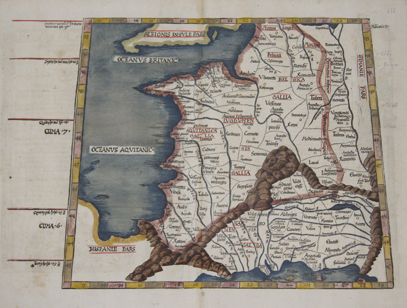
Tabula III Europae
| Article ID | EUF3033 |
Title | Tabula III Europae |
Description | Map shows total France in trapezoid. On reverse the description with splendour-fully columns and ornaments |
| Year | ca. 1535 |
Artist | Ptolemy/ Fries (1490-1531) |
Lorenz (Laurent) Fries was born in Alsace in 1490 or thereabouts, describing himself on one occasion as from Colmar, one of the towns of the region. He studied medicine at university, or rather at universities, as he seems to have had a peripatetic education, apparently spending time at the universities of Pavia, Piacenza, Montpellier and Vienna. Having successfully completed his education, Fries established himself as a physician, at a succession of places in the Alsace region, with a short spell in Switzerland, before settling in Strasbourg, in about 1519. By this time, he had established a reputation as a writer on medical topics, with several publications already to his credit. Indeed, it was thus that Fries met the Strasbourg printer and publisher Johann Grüninger, an associate of the St. Die group of scholars formed by, among others, Walter Lud, Martin Ringmann and Martin Waldseemuller. Gruninger was responsible for printing several of the maps prepared by Waldseemuller, and for supervising the cutting of the maps for the 1513 edition of Ptolemy, edited by the group. This meeting was to introduce a important digression into Fries' life, and for the next five years, from about 1520 to about 1525, he worked in some capacity as a cartographic editor with Gruninger, exploiting the corpus of material that Waldseemuller had created. Claudius Ptolemy ( arround 100- 160 a.C.) Geographia, gives a list of geographic coordinates of spherical longitude and latitude of almost ten thousand point locations on the earth surface, as they were known at his times. The list is organized in Tabulae which cor- respond to specific regions of the three known continents at that time, Africa, Asia and Europe. Research on Ptolemy’s Geographia has started at the University of Thessaloniki, Greece, in the eighties, focused mainly, but not exclusively, on data re- lated to territories which are now under the sovereignty of the modern Greek state. The World of Ptolemy is classified in Regions, since each Chapter is referred to one of them, giving by this way the concept of Atlas as it is understood today. | |
Historical Description | It is estimated that today's France was settled about 48,000 years ago. Important rock paintings from the Paleolithic period have been preserved in the Lascaux cave From 600 BC Chr. Phoenician and Greek traders founded bases on the Mediterranean coast, while Celts settled from the northwest the country that was later called by the Romans as Gaul. The French Middle Ages were marked by the rise of kingship in the constant struggle against the independence of the nobility and the secular violence of the monasteries and religious orders. Starting from today's Île-de-France, the Capetinians enforced the idea of a unitary state, which was underpinned by participation in various crusades. The Normans invaded Normandy repeatedly, hence its name; in 1066 they conquered England. A long series of armed conflicts with England began under Louis VII after Ludwig's divorced wife Eleonore von Poitou and Aquitaine married Heinrich Plantagenet in 1152 and thus about half of France's territory fell to England. Philip II August, together with the Hohenstaufen family, largely displaced England from France until 1299; the English king Henry III Ludwig IX. recognize as suzerain. From 1226 France became an inheritance monarchy; in 1250 Ludwig IX was one of the most powerful rulers in the West. In the 17th and 18th centuries, France held European leadership and supremacy. The political and cultural charisma was significant: The court of Louis XIV became the model for absolutist states throughout Europe and the French Revolution with the declaration of human and civil rights, together with occupations by Napoleon Bonaparte, started in many countries the time and again Setbacks interrupted development towards democracy. |
| Place of Publication | Vienna |
| Dimensions (cm) | 31 x 43 |
| Condition | Perfect condition |
| Coloring | original colored |
| Technique | Woodcut |
Reproduction:
105.00 €
( A reproduction can be ordered individually on request. )