

Adina Sommer
Antique and Contemporary Art
Winzerer Str. 154
80797 München
telephone
+49 89 304714
business hours:
by appointment
Email
![]()


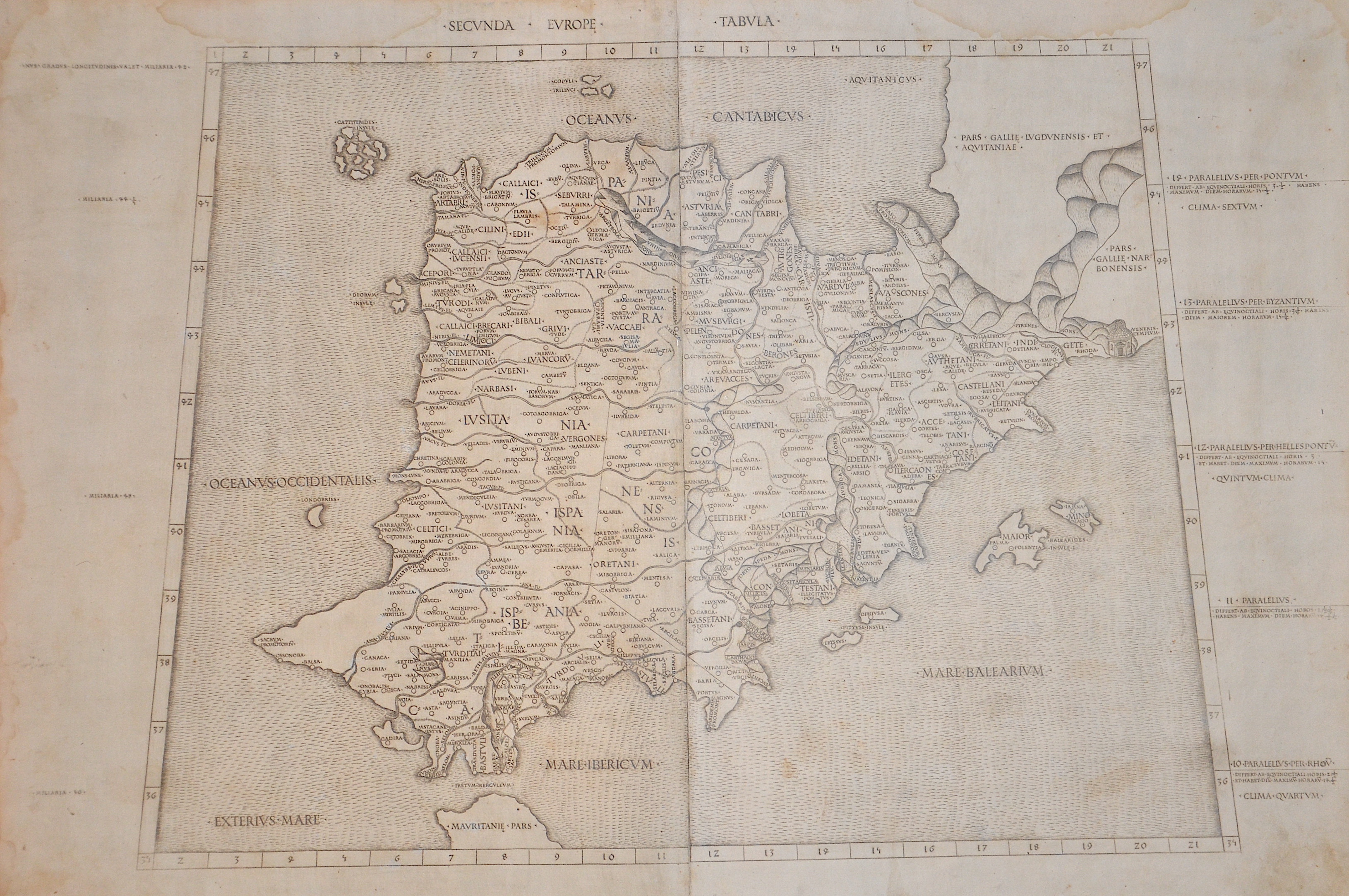
Secunda Europe Tabula
| Article ID | EUE3560 |
Title | Secunda Europe Tabula |
Description | Map shows in trapezoidal form the Iberian Peninsula with Spain, Portugal and the Balearic Islands (Mallorca, Menorca, Ibiza). |
| Year | ca. 1490 |
Artist | Ptolemy/ Petrus de Turre |
Petrus de Turre puchased Conrad Sweynheyms plates in 1490 to reissue the maps based on Claudius Ptolemy notes. Claudius Ptolemy ( arround 100- 160 a.C.) Geographia, gives a list of geographic coordinates of spherical longitude and latitude of almost ten thousand point locations on the earth surface, as they were known at his times. The list is organized in Tabulae which cor- respond to specific regions of the three known continents at that time, Africa, Asia and Europe. Research on Ptolemy’s Geographia has started at the University of Thessaloniki, Greece, in the eighties, focused mainly, but not exclusively, on data re- lated to territories which are now under the sovereignty of the modern Greek state. The World of Ptolemy is classified in Regions, since each Chapter is referred to one of them, giving by this way the concept of Atlas as it is understood today. | |
Historical Description | In prehistoric and prehistoric times, Iberians, Celts and Basques settled on the Iberian peninsula named after the former. In the 11th century BC The Phoenicians settled on the south coast; the most famous of their colonies was Cadiz. The name Spain is derived from the Roman name Hispania (from Phoenician ishapan "land of the rock hyrax". In the early 8th century, the Moors destroyed the Visigoth Empire and conquered the entire Iberian Peninsula. Their centuries of rule shaped the country. The Arabic heritage was reflected in both the architecture and the language. However, the Moors were unable to establish themselves permanently in the northern outskirts of the peninsula. From there the "Reconquest" (Reconquista) started. In this process, which spanned several centuries (722–1492) and was not continuous, the Muslim empires were gradually pushed back by the Christian empires until the fall of Granada in 1492, the last Moorish state structure on the peninsula also disappeared. In the 15th century, the kingdoms of Castile and Aragon were united. Aragon was an important maritime power in the Mediterranean at that time. The Spanish colonial empire extended around 1600 across large parts of South and Central America, the southern part of today's USA and the Philippines. As the English and French also intensified their colonial efforts, Spain gradually lost its supremacy. The liberation wars of the American states, particularly the Mexican and South American wars of independence in the early 19th century, brought independence to most of the colonies. In 1898, the last major properties were lost to the United States during the Spanish-American War, which meant the end of the colonial empire. The African colonies that followed later (Spanish-Morocco, Spanish-Sahara and Equatorial Guinea) finally became independent in the 20th century. |
| Place of Publication | Rome |
| Dimensions (cm) | 34,5 x 54 cm |
| Condition | Very good |
| Coloring | black/white |
| Technique | Woodcut |
Reproduction:
1,125.00 €
( A reproduction can be ordered individually on request. )