

Adina Sommer
Antique and Contemporary Art
Winzerer Str. 154
80797 München
telephone
+49 89 304714
business hours:
by appointment
Email
![]()


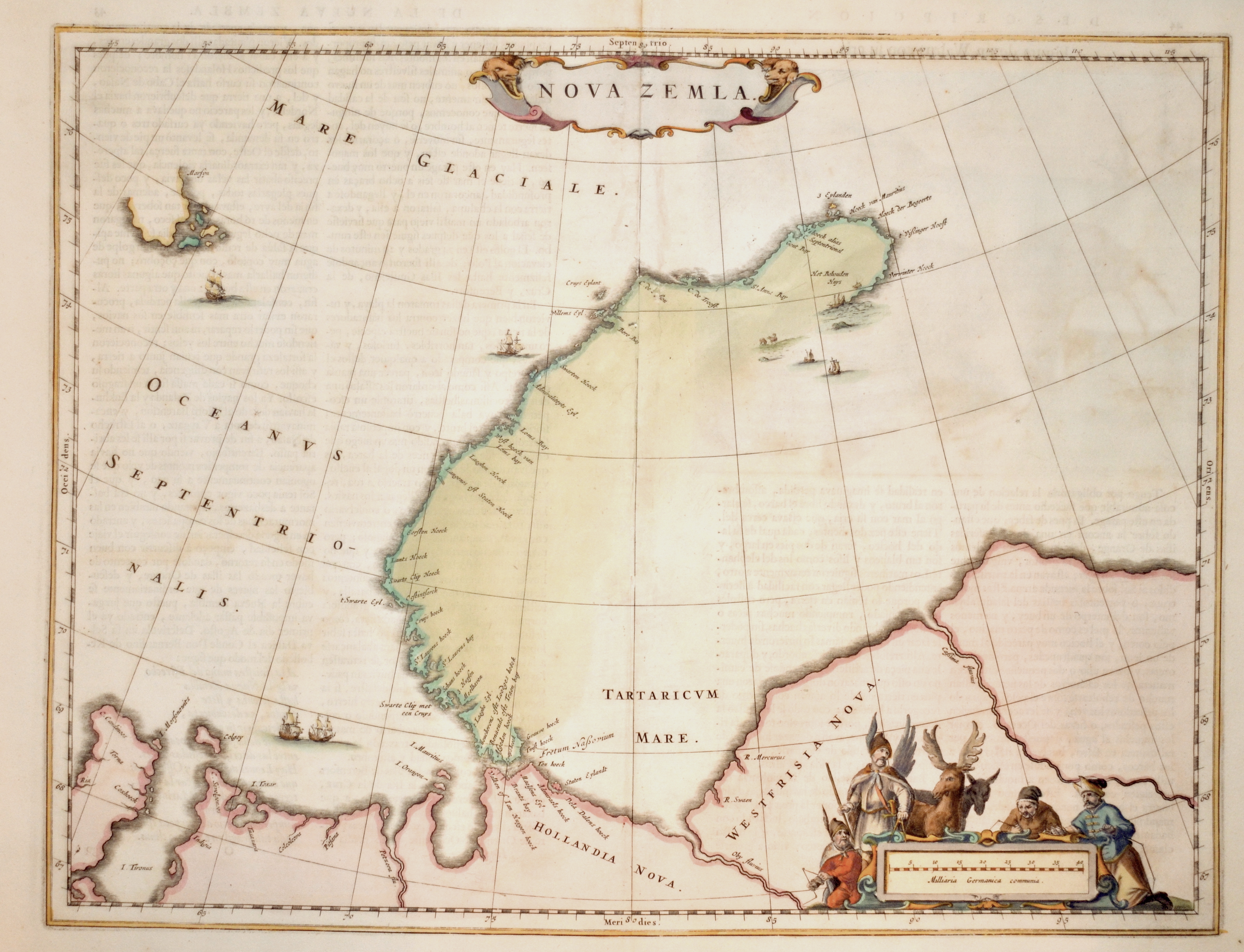
Nova Zemla.

| Article ID | EUO4130 |
Title | Nova Zemla. |
Description | Map shows the russian Nowaja Semlja (Nova Zembla) in the Arctic ocean, the peninsula Jamal and the Obbussen, with two decorative cartouches. On verso fine print of Walrus after Hesselsz. |
| Year | ca. 1650 |
Artist | Blaeu (1571-1638) |
Joan Guilliemus Blaeu was the eldest son of Willem Janszoon Blaeu (1571-1638), and was probably born in Alkmaar in the province of Noord-Holland in the final years of the 16th century. He was brought up in Amsterdam, and studied law at the University of Leiden before going into partnership with his father in the 1630s. Although his father Willem had cartographic interests, having studied under the Danish astronomer Tycho Brahe and having manufactured globes and instruments, his primary business was as a printer. It was under the control of Joan that the Blaeu printing press achieved lasting fame by moving towards the printing of maps and expanding to become the largest printing press in Europe in the 17th century. By the 1660s the Theatrum Orbis Terrarum (or Atlas Maior as it had became known by this time) had expanded to between 9 and 12 volumes, depending on the language. With over 3,000 text pages and approximately 600 maps, it was the most expensive book money could buy in the later 17th century. The translation of the text from Latin into Dutch, English, German, French, and Spanish for several volumes created enormous work for those involved in typography and letterpress activities. It is estimated that over 80 men must have been employed full-time in the Blaeu printing house in Bloemgracht, not including engravers who worked elsewhere, with over 15 printing presses running simultaneously, and in 1667 a second press was acquired at Gravenstraat. At the same time as producing the Atlas Maior, Blaeu was also publishing town plans of Italy, maps for globes, and other volumes. At its peak the Blaeu press managed to produce over 1 million impressions from 1,000 copper plates within four years. | |
Historical Description | Novaya Zemlya also known as Nova Zembla is an archipelago in the Arctic Ocean in northern Russia and the extreme northeast of Europe, the easternmost point of Europe lying at Cape Flissingsky on the Northern island. West of Novaya Zemlya is the Barents Sea, and to the east is the Kara Sea. The Russians knew of Novaya Zemlya from the 11th century, when hunters from Novgorod visited the area. For Western Europeans, the search for the Northern Sea Route in the 16th century led to its exploration. The first visit from a Western European was by Hugh Willoughby in 1553. Dutch explorer Willem Barentsz reached the west coast of Novaya Zemlya in 1594, and in a subsequent expedition of 1596, he rounded the northern cape and wintered on the northeastern coast. Barentsz died during the expedition, and may have been buried on Severny Island. During a later voyage by Fyodor Litke in 1821–1824, the western coast was mapped. On Gerhards Mercator large world map from 1597 , it is alredy named as Nova Zemla. Henry Hudson was another explorer who passed through Novaya Zemlya while searching for the Northeast Passage. |
| Place of Publication | Amsterdam |
| Dimensions (cm) | 38 x 49 cm |
| Condition | Break on the center because of oxidation, professional restored |
| Coloring | original colored |
| Technique | Copper print |
Reproduction:
72.00 €
( A reproduction can be ordered individually on request. )