

Adina Sommer
Antique and Contemporary Art
Winzerer Str. 154
80797 München
telephone
+49 89 304714
business hours:
by appointment
Email
![]()


Les Isles Britanniques
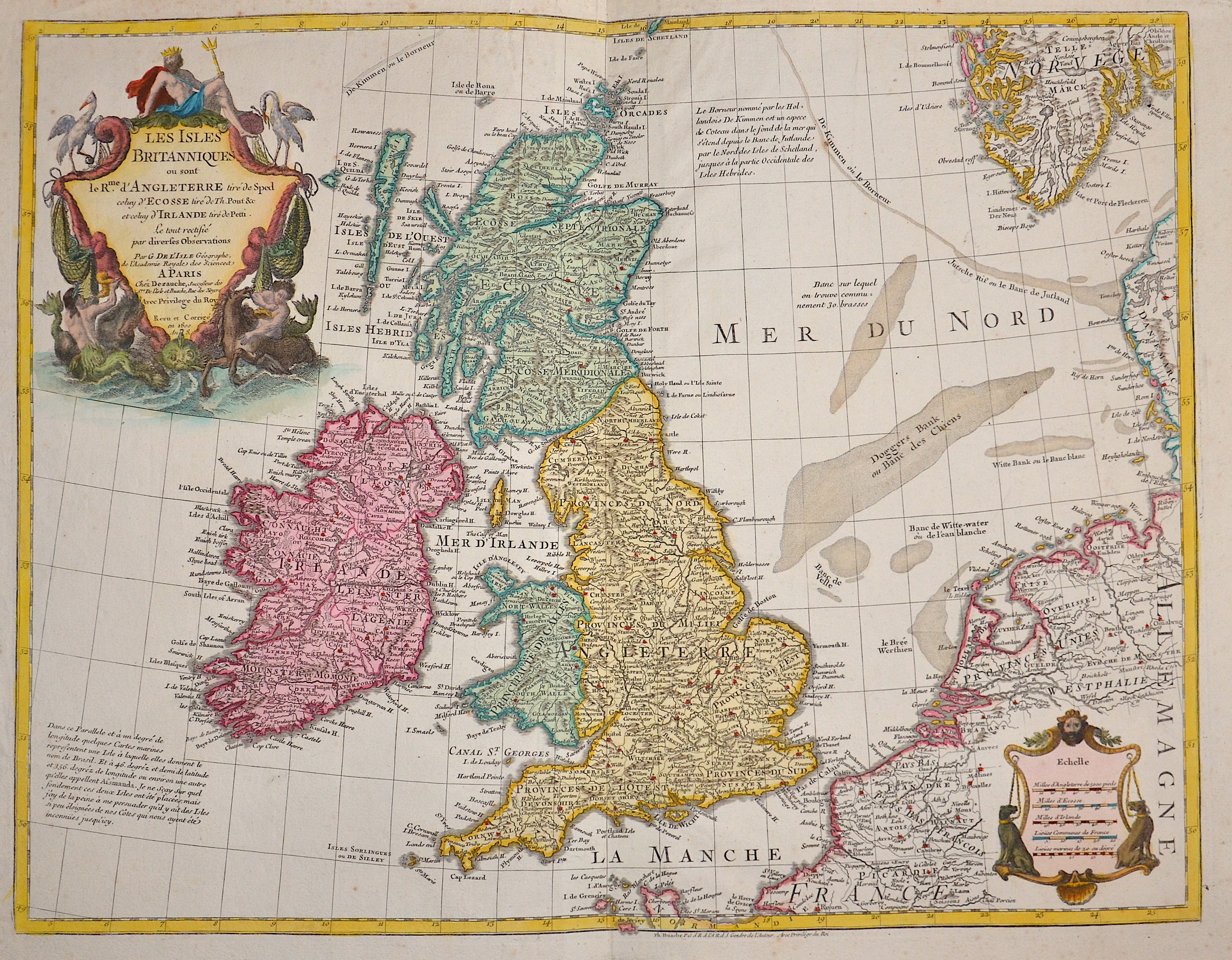
| Article ID | EUG1044 |
Title | Les Isles Britanniques |
Description | Map shows total Great Britain. |
| Year | dated 1800 |
Artist | Dezauche (1780-1838) |
Jean-Claude Dezauche (1780-1838) was the successor to Guillaume De L'Isle and Philipe Buache. Guillaume De L´Isle (1675- 1726) Paris, was a French cartographer known for his popular and accurate maps of Europe and the newly explored Americas and Africa. De L´Isle was admitted into the French Académie Royale des Sciences, an institution financed by the French state. After that date, he signed his maps with the title of “Géographe de l’Académie”. Five years later, he moved to the Quai de l’Horloge in Paris, a true publishing hub where his business prospered. De L´Isle’s ascension through the ranks culminated in 1718 when he received the title of Premier Géographe du Roi. His new office consisted in teaching geography to the Dauphin, King Louis XIV’s son, a task for which he received a salary. De L´Isle’s reputation as a man of science probably helped .This supports the claim of the historian Mary Sponberg Pedley, who says “once authority was established, a geographer’s name might retain enough value to support two or three generations of mapmakers”. In De L´Isle’s case, it could be said that his accomplishments surpassed his father’s. Up to that point, he had drawn maps not only of European countries, such as Italy, Spain, Germany, Great Britain, Poland, and regions such as the Duchy of Burgundy, but he had also contributed to the empire’s claims to recently explored continents of Africa and the Americas. Like many cartographers of these days, De L´Isle did not travel with the explorers and elaborated the maps mostly in his office. The quality of his maps depended on a solid network that would provide him first-hand information. Given the family’s reputation and his own, De L´Isle had access to fairly recent accounts of travellers who were coming back from the New World, which gave him an advantage over his competitors. Being a member of the Académie, he was also aware of recent discoveries, especially in astronomy and measurement. When he could not confirm the accuracy of his source, he would indicate it clearly on his maps. For instance, his Carte de la Louisiane shows a river that the baron of Lahontan claimed he discovered, but no one else could validate it, so De L`lsle warned the viewer that its actual existence was in doubt. De L´Isle 's search for exactitude and intellectual honesty entangled him in a legal dispute in 1700 with Jean-Baptiste Nolin, a fellow cartographer. Noticing Nolin had used details that were considered original from his Map of the World, De L´isle dragged Nolin in court to prove his plagiarism. In the end, Delisle managed to convince the jury of scientists that Nolin only knew the old methods of cartography and therefore that he had stolen the information from his manuscript. Nolin's maps were confiscated and he was forced to pay the court costs.The scientificity of the work produced by the De L´Isle family contrasted with the workshop of Sanson. While Sanson knowingly published outdated facts and mistakes, De L´Isle strived to present up-to-date knowledge. | |
Historical Description | The Romans settled for the first time under the leadership of Caesar 55 and 54 BC. BC in England, but initially not as a conqueror. It was not until almost a century later that the Romans occupied England. Scottish ethnic groups repeatedly penetrated the power vacuum that emerged after the Roman withdrawal around 410 AD. Subsequently, groups of Anglers, Jutters and Saxons immigrated. This was the beginning of the early Middle Ages in Britain. The Danish Vikings finally sailed to England in the late 8th century. At first, they only carried out raids, but later they established themselves, asked for tribute payments and built their own villages. Wilhelm's victory in the High Middle Ages led to the introduction of the Normans' effective armrest system. A small Norman upper class almost completely replaced the established nobility. In the period from the middle of the 10th to the middle of the 14th century, the population tripled, and agriculture was intensified with the introduction of three-field farming and land reclamation. However, self-sufficiency with food only succeeded in climatically favorable and politically stable times. The Hundred Years War broke out in the late Middle Ages, the deposition of Richard II by later Henry IV and the failures in the Hundred Years War were the reasons for the outbreak of the subsequent Rose Wars. During the Tudor period, the Renaissance of England peaked through Italian courtiers who reintroduced the artistic, educational, and scientific debate from antiquity. England began to develop naval skills, and exploration of the West and Europe intensified. Henry VIII broke out of communion with the Catholic Church in connection with his divorce under the Acts of Supremacy of 1534, which proclaimed the monarch head of the Church of England. Unlike much of European Protestantism, the roots of the split were political rather than theological. There were internal religious conflicts during the reign of Henry's daughters Mary I and Elizabeth I. The former brought the country back to Catholicism, while the latter abandoned it and vigorously maintained the predominance of Anglicanism. The Elizabethan era began with Elizabeth I's accession to the throne in 1588. The new, Protestant queen was enthusiastically received by the people. From the beginning of her reign, a possible marriage of the queen was the dominant issue. Parliaments repeatedly asked them to obtain a male heir to the throne. She was responsible for the implementation of the Reformation, but also for the poorer relations with Spain. |
| Place of Publication | Paris |
| Dimensions (cm) | 47 x 61 |
| Condition | Very good |
| Coloring | colored |
| Technique | Copper print |
Reproduction:
57.00 €
( A reproduction can be ordered individually on request. )