

Adina Sommer
Antique and Contemporary Art
Winzerer Str. 154
80797 München
telephone
+49 89 304714
business hours:
by appointment
Email
![]()


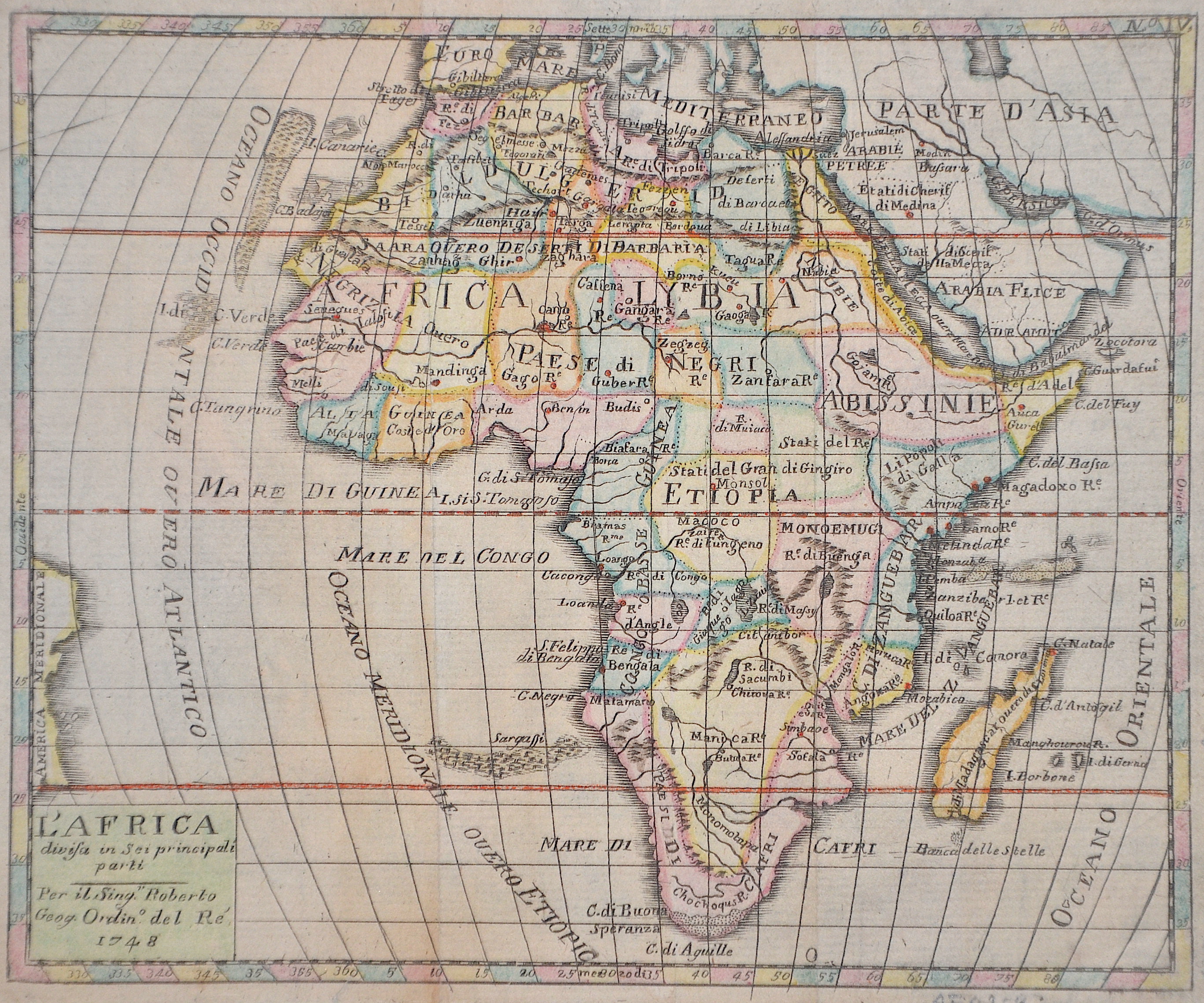
L’Africa divis in Sei principali parti
| Article ID | AF0354 |
Title | L’Africa divis in Sei principali parti |
Description | Map depicts Africa with Madagaskar and the Arabia peninsula. |
| Year | dated 1748 |
Artist | Vaugondy, de (1723-1786) |
Didier Robert de Vaugondy (1723 -1786) also known as Le Sieur or Monsieur Robert, and his son, were leading cartographers in France during the 18th century. In 1757, Gilles and Didier Robert De Vaugondy published The Atlas Universel, one of the most important atlases of the 18th century. To produce the atlas, the Vaugondys integrated older sources with more modern surveyed maps. They verified and corrected the latitude and longitude of many regional maps in the atlas with astronomical observations. The older material was revised with the addition of many new place names. In 1760, Didier Robert de Vaugondy was appointed geographer to Louis XV. Gilles and Didier Robert De Vaugondy produced their maps and terrestrial globes working together as father and son. Globes of a variety of sizes were made by gluing copperplate-printed gores on a plaster-finished papier-mache core, a complicated and expensive manufacturing process, employing several specialists. In some cases it is uncertain whether Gilles or Didier made a given map. Gilles often signed maps as M.Robert, while Didier commonly signed his maps as ""Robert de Vaugondy"", or added ""fils"" or ""filio"" after his name. The Robert de Vaugondys were descended from the Nicolas Sanson family through Sanson's grandson, Pierre Moulard-Sanson. From him, they inherited much of Sanson's cartographic material, which they combined with maps and plates acquired after Hubert Jaillot's death in 1712 to form the basis the Atlas Universel. | |
Historical Description | According to the "Out-of-Africa theory", Africa is considered the "cradle of mankind", where homo development led to the development of the anatomically modern human Homo sapiens. One of the earliest advanced civilizations in mankind was formed in ancient Egypt. Over the millennia, various "great empires" such as the Empire of Abyssinia emerged on the continent. There were other kingdoms in West Africa, such as the Ashanti and Haussa, but they emerged much later. There were also some important cultures in East and South Africa, as in the area of today's Sudan, then called Nubia or Kush. Nubian pharaohs ruled all of Egypt for a dynasty. For example, the inhabitants of Greater Zimbabwe were important cultures in southern Africa. This stone castle was architecturally a masterpiece at that time and important for trade between the peoples of the south and east. The Swahili were known in East Africa. North Africa was connected to Europe and the Near East by the Mediterranean rather than separated. Carthage, a foundation of the Phoenicians in what is now Tunisia, was around the middle of the 1st millennium BC. The dominant power in the western Mediterranean until it was replaced by Rome in the Punic Wars. This prevailed from 30 BC. BC (conquest of Egypt) over all of North Africa. Even the ancient Egyptians (Queen Hatshepsut) made trips to Punt, probably in what is now Somalia. The kingdom of the Queen of Sheba, which probably had its center in southern Arabia, is said to have spanned parts of the Horn from Africa to the north of Ethiopia. |
| Place of Publication | Paris |
| Dimensions (cm) | 16 x 19,5 cm |
| Condition | Perfect condition |
| Coloring | colored |
| Technique | Copper print |
Reproduction:
18.00 €
( A reproduction can be ordered individually on request. )