

Adina Sommer
Antique and Contemporary Art
Winzerer Str. 154
80797 München
telephone
+49 89 304714
business hours:
by appointment
Email
![]()


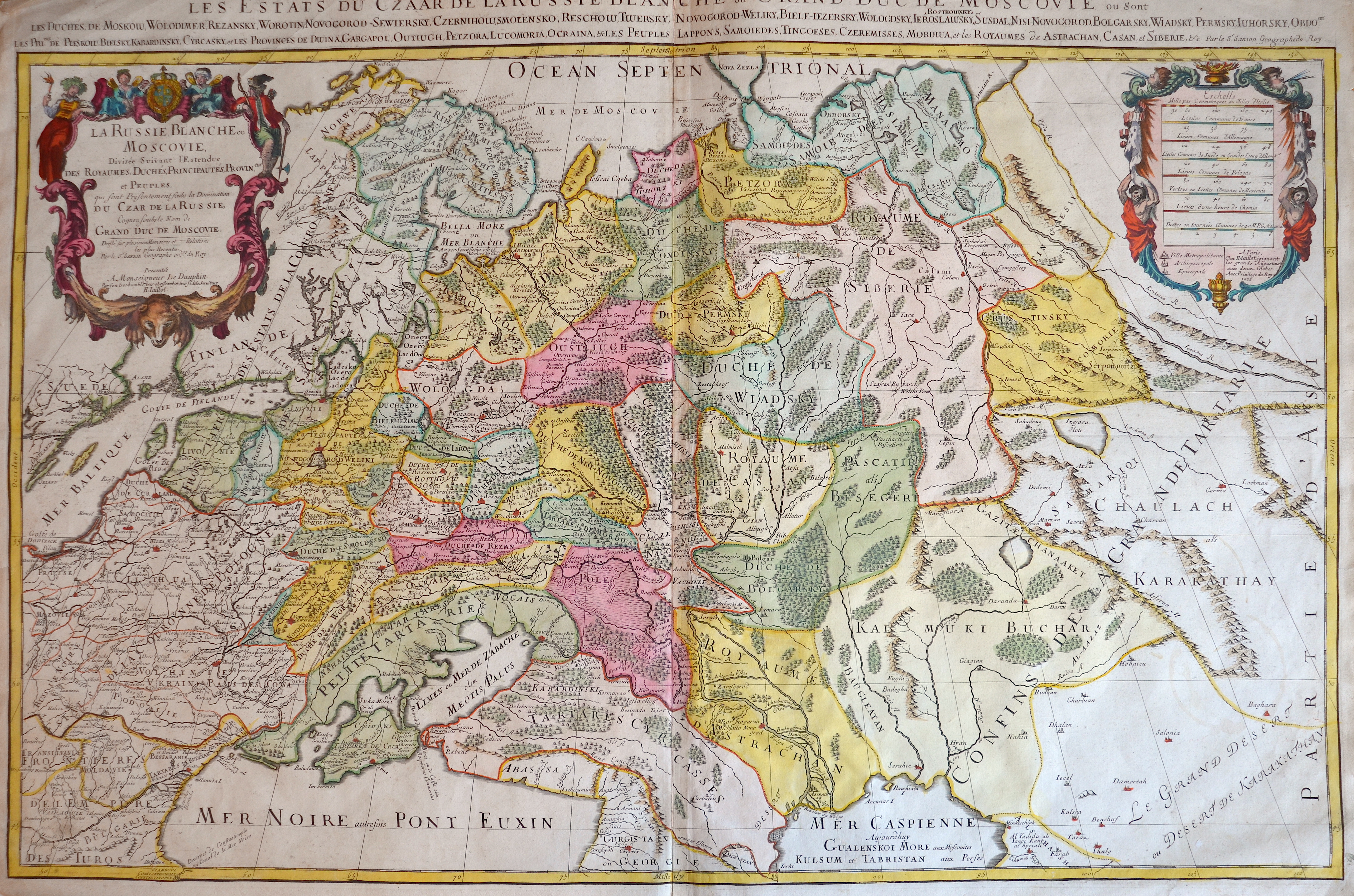
La Russie Blanche ou Moscovie,.

| Article ID | EUO4168 |
Title | La Russie Blanche ou Moscovie,. |
Description | Decorative map with two cartoiuches, shows the northwestern part aof Russia with Ukrain and the peninsula Krim. Partzly the black sea, the Caspian sea and the peninsula Kola. |
| Year | ca. 1685 |
Artist | Jaillot/ Sanson (1632-1712) |
Alexis Hubert Jaillot ( 1632 -1712) was one of the most important French cartographers of the 17th century. In 1665 he married the daughter of the cartographer family Berey. After the death of his brother-in-law, Nicolas II Berey (1640–1667), he bought from his sister–in–law the Berey map collection. This was the beginning of his career as a publisher. Later, in 1670, he had a partnership with Nicolas Sanson's son and re-published and re-engraved many of his maps. The atlases and maps mainly have been printed by Pierre Mortier in Amsterdam and Paris. | |
Historical Description | Neanderthal settlement in Ukraine is seen in the Molodova archaeological sites, which include a mammoth bone dwelling. The territory is also considered to be the likely location for the human domestication of the horse. In the mid-14th century, upon the death of Bolesław Jerzy II of Mazovia, king Casimir III of Poland initiated campaigns (1340–1366) to take Galicia-Volhynia. Meanwhile, the heartland of Rus', including Kiev, became the territory of the Grand Duchy of Lithuania, ruled by Gediminas and his successors, after the Battle on the Irpen' River. In 1648, Bohdan Khmelnytsky and Petro Doroshenko led the largest of the Cossack uprisings against the Commonwealth and the Polish king John II Casimir. After Khmelnytsky made an entry into Kiev in 1648, where he was hailed liberator of the people from Polish captivity, he founded the Cossack Hetmanate which existed until 1764. In 1657–1686 came "The Ruin", a devastating 30-year war amongst Russia, Poland, Turks and Cossacks for control of Ukraine. In 1709, Cossack Hetman Ivan Mazepa (1639–1709) defected to Sweden against Russia in the Great Northern War (1700–1721). Lithuanians and Poles controlled vast estates in Ukraine, and were a law unto themselves. After the Annexation of Crimea by the Russian Empire in 1783, New Russia was settled by Ukrainians and Russians. |
| Place of Publication | Paris |
| Dimensions (cm) | 59 x 88,5 cm |
| Condition | Printed on 2 sheets joined together |
| Coloring | colored |
| Technique | Copper print |
Reproduction:
90.00 €
( A reproduction can be ordered individually on request. )