

Adina Sommer
Antique and Contemporary Art
Winzerer Str. 154
80797 München
telephone
+49 89 304714
business hours:
by appointment
Email
![]()


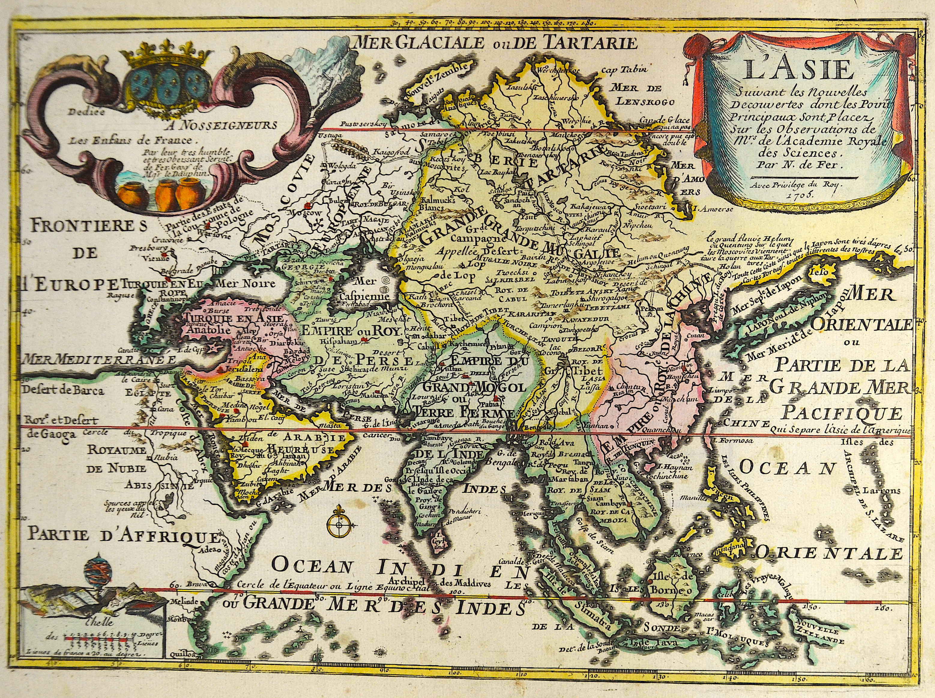
L’ Asie Suivant les Nouvelles Decouvertes dont les Point Principaux ..
| Article ID | ASX0944 |
Title | L’ Asie Suivant les Nouvelles Decouvertes dont les Point Principaux .. |
Description | Decorative map shows complete Asia with three decorative cartouches.This map, which is original to De Fer, is a continuous landbridge extending from northern Korea and eastern Siberia across to America. Hokkaido appears as a small circular island north of Japan.The northern coastline of Asia is based on Witsen's explorations including Cap Tabin and Cap Glace. The interior is filled with details, including what appears to be a road from Moscow to Peking, and the Great Wall of China.The Caspian Sea is presented in an unusual shape. India is misshapen and the coastline of a portion of New Guinea is incorrectly named as Nouvelle Zeelande. |
| Year | dated 1705 |
Artist | Fer, de (1646-1720) |
Nicolas de Fer ( 1646 - 1720 in Paris) was a French cartographer and geographer. He also was an engraver and publisher. De Fer was the youngest of three sons of Antoine de Fer, who was also a cartographer. When he was 12, he became the apprentice of Parisian engraver Louis Spirinx, and made his first map, of the Canal du Midi, at the age of 23. After the death of his father in June 1673, de Fer was so successful at improving the firm that, in 1690, he became the official geographer to Louis, Dauphin of France. With support from the Spanish and French Royal Families, de Fer also became official geographer for Philip V and Louis XIV, the kings of Spain and France, respectively. Because of this, his maps became Bourbon propaganda, endorsing French King Louis XIV. His business flourished, producing town plans, atlases, wall maps, and more than 600 sheet maps.He made maps of places in Europe and North America, including New Spain, places fortified by Vauban, the Low Countries, and the War of the Spanish Succession. In 1698, de Fer published a map of North America, which included a depiction of beavers building dams near Niagara Falls. Seventeen years later, Herman Moll published an identical map as his own, known as the -Beaver map-. De Fer became the official geographer for His Catholic Majesty in 1720.Two of his sons-in-law, Guillaume Danet and Jaques-François Bénard, continued the company after de Fer's death on 25 October of that year until around 1760. | |
Historical Description | Asia is Earth's largest and most populous continent, located primarily in the Eastern and Northern Hemispheres. The history of Asia can be seen as the distinct histories of several peripheral coastal regions: East Asia, South Asia, Southeast Asia and the Middle East, linked by the interior mass of the Central Asian steppes. The coastal periphery was home to some of the world's earliest known civilizations, each of them developing around fertile river valleys. The civilizations in Mesopotamia, the Indus Valley and the Yellow River shared many similarities. These civilizations may well have exchanged technologies and ideas such as mathematics and the wheel. Other innovations, such as writing, seem to have been developed individually in each area. Cities, states and empires developed in these lowlands. The central steppe region had long been inhabited by horse-mounted nomads who could reach all areas of Asia from the steppes. The earliest postulated expansion out of the steppe is that of the Indo-Europeans, who spread their languages into the Middle East, South Asia, and the borders of China, where the Tocharians resided. The northernmost part of Asia, including much of Siberia, was largely inaccessible to the steppe nomads, owing to the dense forests, climate and tundra. These areas remained very sparsely populated. The center and the peripheries were mostly kept separated by mountains and deserts. The Caucasus and Himalaya mountains and the Karakum and Gobi deserts formed barriers that the steppe horsemen could cross only with difficulty. While the urban city dwellers were more advanced technologically and socially, in many cases they could do little in a military aspect to defend against the mounted hordes of the steppe. However, the lowlands did not have enough open grasslands to support a large horsebound force; for this and other reasons, the nomads who conquered states in China, India, and the Middle East often found themselves adapting to the local, more affluent societies. |
| Place of Publication | Paris |
| Dimensions (cm) | 23 x 32 |
| Condition | Perfect condition |
| Coloring | original colored |
| Technique | Copper print |
Reproduction:
48.00 €
( A reproduction can be ordered individually on request. )