

Adina Sommer
Antique and Contemporary Art
Winzerer Str. 154
80797 München
telephone
+49 89 304714
business hours:
by appointment
Email
![]()


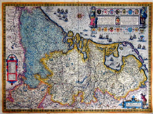
Inferioris Germaniae Provinciarum Nova Descriptio

| Article ID | EUN1499 |
Title | Inferioris Germaniae Provinciarum Nova Descriptio |
Description | Map shows total Netherland, east Frisia, Belgium |
| Year | ca. 1608 |
Artist | Vrients/Ortelius |
Historical Description | The area, which later includes the Benelux area, is called de Lage Landen in Dutch, Low Countries in English, consisting of Belgium, the Netherlands (Nederland) and Luxembourg. In the 19th century, three countries were united under the crown of the Dutch king from 1815 to 1830, until Belgium became independent. The forerunners of the Benelux Treaty were the economic union concluded between Luxembourg and Belgium on July 25, 1921. |
| Place of Publication | Antwerp |
| Dimensions (cm) | 41 x 56 |
| Condition | perfectly restored |
| Coloring | original colored |
| Technique | Copper print |
Reproduction:
765.00 €
( A reproduction can be ordered individually on request. )