

Adina Sommer
Antique and Contemporary Art
Winzerer Str. 154
80797 München
telephone
+49 89 304714
business hours:
by appointment
Email
![]()


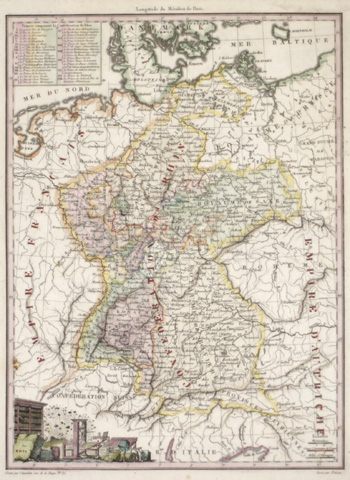
Confederal du Rhin
| Article ID | EUD2713 |
Title | Confederal du Rhin |
Description | Map shows the total river Rhein |
| Year | ca. 1810 |
Artist | Pelicier |
Historical Description | The headwaters of the Rhine lie predominantly in the Swiss canton of Graubünden; its estuary arms reach the North Sea in the Netherlands, where it is the most water-rich tributary. The Rhine bears its name without distinguishing additions only from the confluence of the Vorderrhein and Hinterrhein at Tamins-Reichenau. Traditionally, Lake Toma near the Oberalp Pass near Sedrun in the Gotthard region is considered the source of the Vorderrhein and the Rhine as a whole. The Hinterrhein rises in the high valley Rheinwald below the Rheinwaldhorn. At Tamins-Reichenau the Vorderrhein and Hinterrhein join to form the Alpenrhein.Hochrhein: The Hochrhein begins at Stein am Rhein at the western end of the Untersee. In contrast to the Alpine Rhine and the Upper Rhine, it flows mainly to the west, dropping from 395 m to 252 m. The Rhine is the first major river in the world. In the center of Basel, the first large city on the course of the stream, lies the "Rhine bend"; here the High Rhine ends. Upper Rhine: At Mainz, the Rhine leaves the Upper Rhine Graben and flows through the Mainz Basin. The section of the Upper Rhine from Mainz down through the Rheingau and Rheinhessen is also known as the Inselrhein. The Upper Rhine Valley was already an important cultural landscape in Europe in ancient times and the Middle Ages. Today, the Upper Rhine is the location of numerous important industrial and service companies with the centers in Basel, Strasbourg and Mannheim-Ludwigshafen. Middle Rhine: The Mainz Basin ends at Bingen. The largest tributaries of the Middle Rhine are the Lahn and Moselle, which flow in from the right and left at Koblenz. Almost the entire length of the Middle Rhine runs through the state of Rhineland-Palatinate. The valley area between Rüdesheim and Koblenz is part of the UNESCO World Heritage Upper Middle Rhine Valley. At Sankt Goarshausen, the Rhine encloses the famous Loreley Rock with a sharp river bend, where it reaches a depth of 25 meters. With its high-ranking architectural monuments, vine-covered slopes, towns crowded together on narrow banks and hilltop castles strung on rocky outcrops, the Middle Rhine Valley is considered the epitome of Rhine Romanticism. Lower Rhine: Near Bonn, north of the Siebengebirge, the Rhine changes from the low mountain region to the North German lowlands and becomes the Lower Rhine at the mouth of the Sieg. The Lower Rhine lies entirely in North Rhine-Westphalia. Its banks are mostly heavily populated and industrialized, especially in the agglomerations of Cologne, Düsseldorf and the Ruhr area. Delta Rhine: At the Dutch-German state border, the Rhine-Meuse delta, the most important natural unit of the Netherlands, begins with the Rhine division, and thus the Delta Rhine. |
| Place of Publication | Paris |
| Dimensions (cm) | 29 x 22 |
| Condition | Very good |
| Coloring | colored |
| Technique | Copper print |
Reproduction:
21.00 €
( A reproduction can be ordered individually on request. )