

Adina Sommer
Antique and Contemporary Art
Winzerer Str. 154
80797 München
telephone
+49 89 304714
business hours:
by appointment
Email
![]()


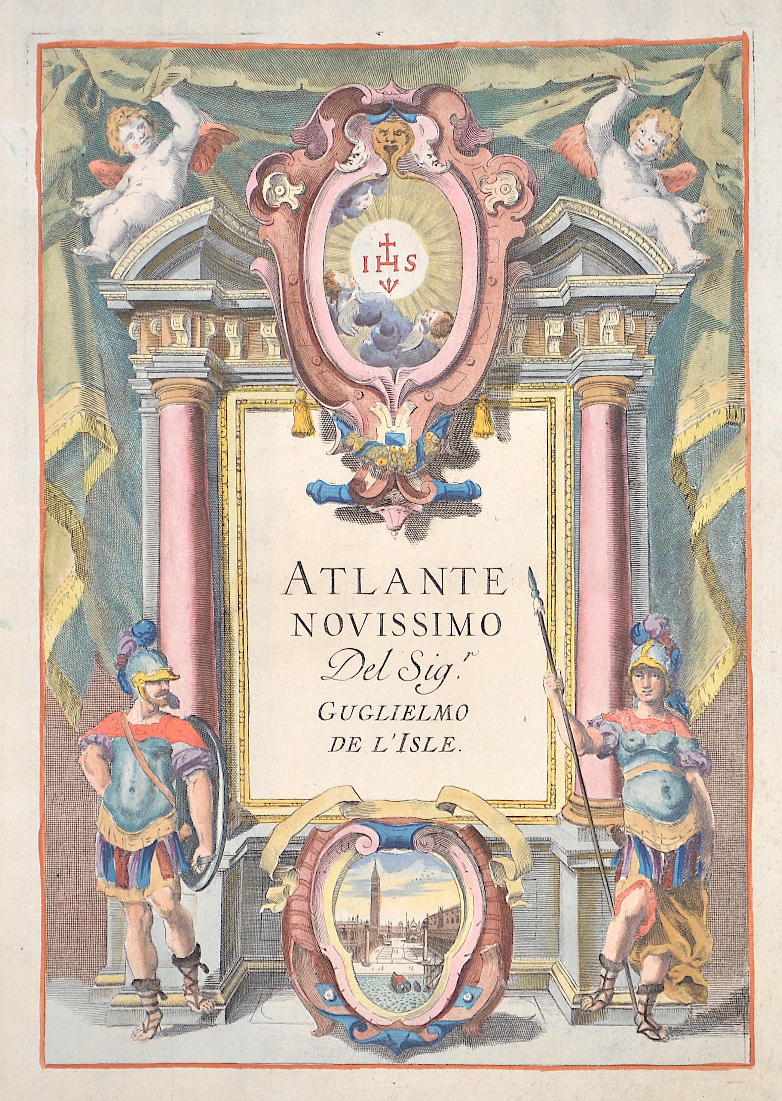
Atlante novissimo del Sig.

| Article ID | T0101 |
Title | Atlante novissimo del Sig. |
Description | Titlepage showing male and female soldiers ans a view of St Mark's Square and the canals of Venice, |
| Year | ca. 1750 |
Artist | L´Isle, de/ Albizzi G. (1675-1726) |
Guillaume De L´isle (1675- 1726) Paris, was a French cartographer known for his popular and accurate maps of Europe and the newly explored Americas and Africa. De L´isle was admitted into the French Académie Royale des Sciences, an institution financed by the French state. After that date, he signed his maps with the title of “Géographe de l’Académie”. Five years later, he moved to the Quai de l’Horloge in Paris, a true publishing hub where his business prospered. De L´isle’s ascension through the ranks culminated in 1718 when he received the title of Premier Géographe du Roi. His new office consisted in teaching geography to the Dauphin, King Louis XIV’s son, a task for which he received a salary. De L´sle’s reputation as a man of science probably helped .This supports the claim of the historian Mary Sponberg Pedley, who says “once authority was established, a geographer’s name might retain enough value to support two or three generations of mapmakers”. In De L´isle’s case, it could be said that his accomplishments surpassed his father’s. Up to that point, he had drawn maps not only of European countries, such as Italy, Spain, Germany, Great Britain, Poland, and regions such as the Duchy of Burgundy, but he had also contributed to the empire’s claims to recently explored continents of Africa and the Americas. Like many cartographers of these days, De L´isle did not travel with the explorers and elaborated the maps mostly in his office. The quality of his maps depended on a solid network that would provide him first-hand information. Given the family’s reputation and his own, De L´isle had access to fairly recent accounts of travellers who were coming back from the New World, which gave him an advantage over his competitors. Being a member of the Académie, he was also aware of recent discoveries, especially in astronomy and measurement. When he could not confirm the accuracy of his source, he would indicate it clearly on his maps. For instance, his Carte de la Louisiane shows a river that the baron of Lahontan claimed he discovered, but no one else could validate it, so Delisle warned the viewer that its actual existence was in doubt. De L´isle 's search for exactitude and intellectual honesty entangled him in a legal dispute in 1700 with Jean-Baptiste Nolin, a fellow cartographer. Noticing Nolin had used details that were considered original from his Map of the World, De L´isle dragged Nolin in court to prove his plagiarism. In the end, Delisle managed to convince the jury of scientists that Nolin only knew the old methods of cartography and therefore that he had stolen the information from his manuscript. Nolin's maps were confiscated and he was forced to pay the court costs.The scientificity of the work produced by the De L´isle family contrasted with the workshop of Sanson. While Sanson knowingly published outdated facts and mistakes, De L´isle strived to present up-to-date knowledge. | |
Historical Description | The title page is one of the most important parts of the "front matter" or "preliminaries" of a book, as the data on it and its verso (together known as the "title leaf") are used to establish the "title proper and usually, though not necessarily, the statement of responsibility and the data relating to publication".This determines the way the book is cited in library catalogs and academic references. The title page often shows the title of the work, the person or body responsible for its intellectual content, and the imprint, which contains the name and address of the book's publisher and its date of publication. Particularly in paperback editions it may contain a shorter title than the cover or lack a descriptive subtitle. Further information about the publication of the book, including its copyright information, is frequently printed on the verso of the title page. The first printed books, or incunabula, did not have title pages: the text simply begins on the first page, and the book is often identified by the initial words—the incipit—of the text proper. Maps were usually published in atlases. And atlases were books with titles. And, again, titles were individual pieces of art. A publisher emphazised the importance of a book he published with a spectacular entrée. Usually the pictures of an atlas title page pertained in general to the subject matter: Measuring instruments, mythologigal, astronomical, religious, scientific, allegorical hints and facts were united in a composition which depicted the pride of progress in knowledge. An atlas title page often is just one superb artistic and jubilant cartouche. |
| Place of Publication | Venice |
| Dimensions (cm) | 29 x 20 |
| Condition | Very good |
| Coloring | original colored |
| Technique | Copper print |
Reproduction:
52.50 €
( A reproduction can be ordered individually on request. )