

Adina Sommer
Antique and Contemporary Art
Winzerer Str. 154
80797 München
telephone
+49 89 304714
business hours:
by appointment
Email
![]()


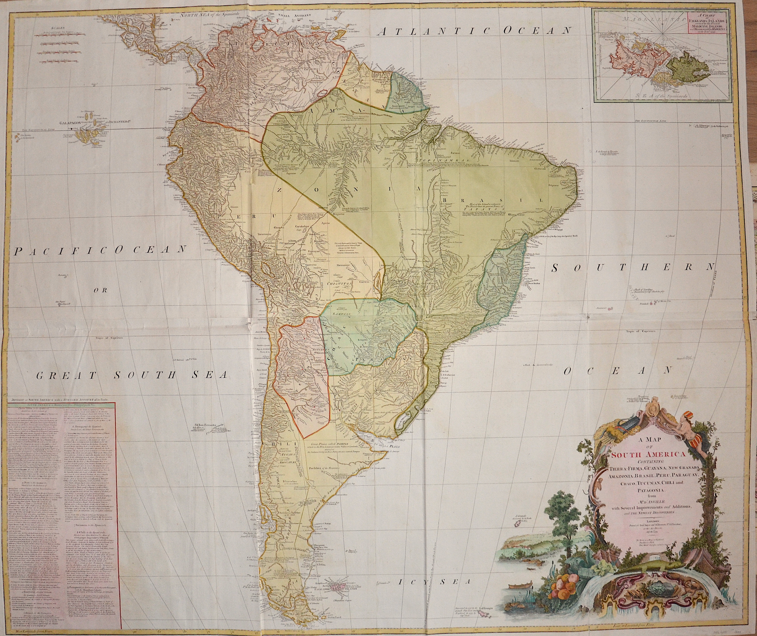
A Map of South America Containing Tierra-Firma, Guayana, New Granada, Amazonia, Brasil, Peru, Paraguay, Chaco, Tucuman, Chili and Patagonia.
| Article ID | AMS1094 |
Title | A Map of South America Containing Tierra-Firma, Guayana, New Granada, Amazonia, Brasil, Peru, Paraguay, Chaco, Tucuman, Chili and Patagonia. |
Description | Map shows the whole of South America with detailed depiction of all country borders, rivers, lakes and mountains. With the Falkland Islands as a partial map and an index. |
| Year | dated 1794 |
Artist | Anville´d (1697-1782) |
Jean Baptiste Bourguignon d'Anville (1697 -1782), was a French geographer and the reformer of old and new cartography. Bourguignon d'Anville devoted himself early to geographical studies, already in the age of 21 became a royal geographer.With this appointment he later rose as a private secretary of Louis, Duke of Orléans. He published 211 maps and became a member of the Académie des sciences in 1773. His valuable map collection, consisting of 10,500 numbers, was purchased for the Royal Library of Paris, now the Bibliothèque Nationale de France. Jean Baptiste Bourguignon d'Anville, was a geographer and cartographer who greatly improved the standards of map making. Particularly valuable are his maps of ancient geography, which are characterized by careful, accurate work and are largely based on original research. He left unknown areas of continents blank and noted dubious information as such; compared to the elaborate maps of his predecessors, his maps seemed empty. His first serious map, that of ancient Greece, was published when he was fifteen years old. At the age of twenty-two he was appointed one of the king's geographers and began to attract the attention of the first authorities. D'Anville's studies included everything geographical in the world's literature as far as he could find it: To this end, he searched not only ancient and modern historians, travelers, and storytellers of every kind, but also poets, orators, and philosophers. One of his favorite themes was to reform geography by putting an end to blind copying of older maps, by testing the generally accepted positions of places by a rigorous examination of all descriptive authority, and by excluding from cartography any name that was inadequately supported. | |
Historical Description | One of the earliest known South American civilizations was at Norte Chico, on the central Peruvian coast. Though a pre-ceramic culture, the monumental architecture of Norte Chico is contemporaneous with the pyramids of Ancient Egypt. In 1494, Portugal and Spain, the two great maritime European powers of that time, on the expectation of new lands being discovered in the west, signed the Treaty of Tordesillas, by which they agreed, with the support of the Pope, that all the land outside Europe should be an exclusive duopoly between the two countries. Beginning in the 1530s, the people and natural resources of South America were repeatedly exploited by foreign conquistadors, first from Spain and later from Portugal. These competing colonial nations claimed the land and resources as their own and divided it in colonies. The Spaniards were committed to convert their native subjects to Christianity and were quick to purge any native cultural practices that hindered this end; however, many initial attempts at this were only partially successful, as native groups simply blended Catholicism with their established beliefs and practices. Furthermore, the Spaniards brought their language to the degree they did with their religion, although the Roman Catholic Church's evangelization in Quechua, Aymara, and Guaraní actually contributed to the continuous use of these native languages albeit only in the oral form. Guyana was first a Dutch, and then a British colony, though there was a brief period during the Napoleonic Wars when it was colonized by the French. The country was once partitioned into three parts, each being controlled by one of the colonial powers until the country was finally taken over fully by the British. The first South American country to abolish slavery was Chile in 1823, Uruguay in 1830, Bolivia in 1831, Colombia and Ecuador in 1851, Argentina in 1853, Peru and Venezuela in 1854, Paraguay in 1869, and in 1888 Brazil was the last South American nation and the last country in western world to abolish slavery. |
| Place of Publication | London |
| Dimensions (cm) | 95,5 x 118 |
| Condition | Printed on 4 sheets joined together |
| Coloring | original colored |
| Technique | Copper print |
Reproduction:
240.00 €
( A reproduction can be ordered individually on request. )