

Adina Sommer
Antique and Contemporary Art
Winzerer Str. 154
80797 München
telephone
+49 89 304714
business hours:
by appointment
Email
![]()


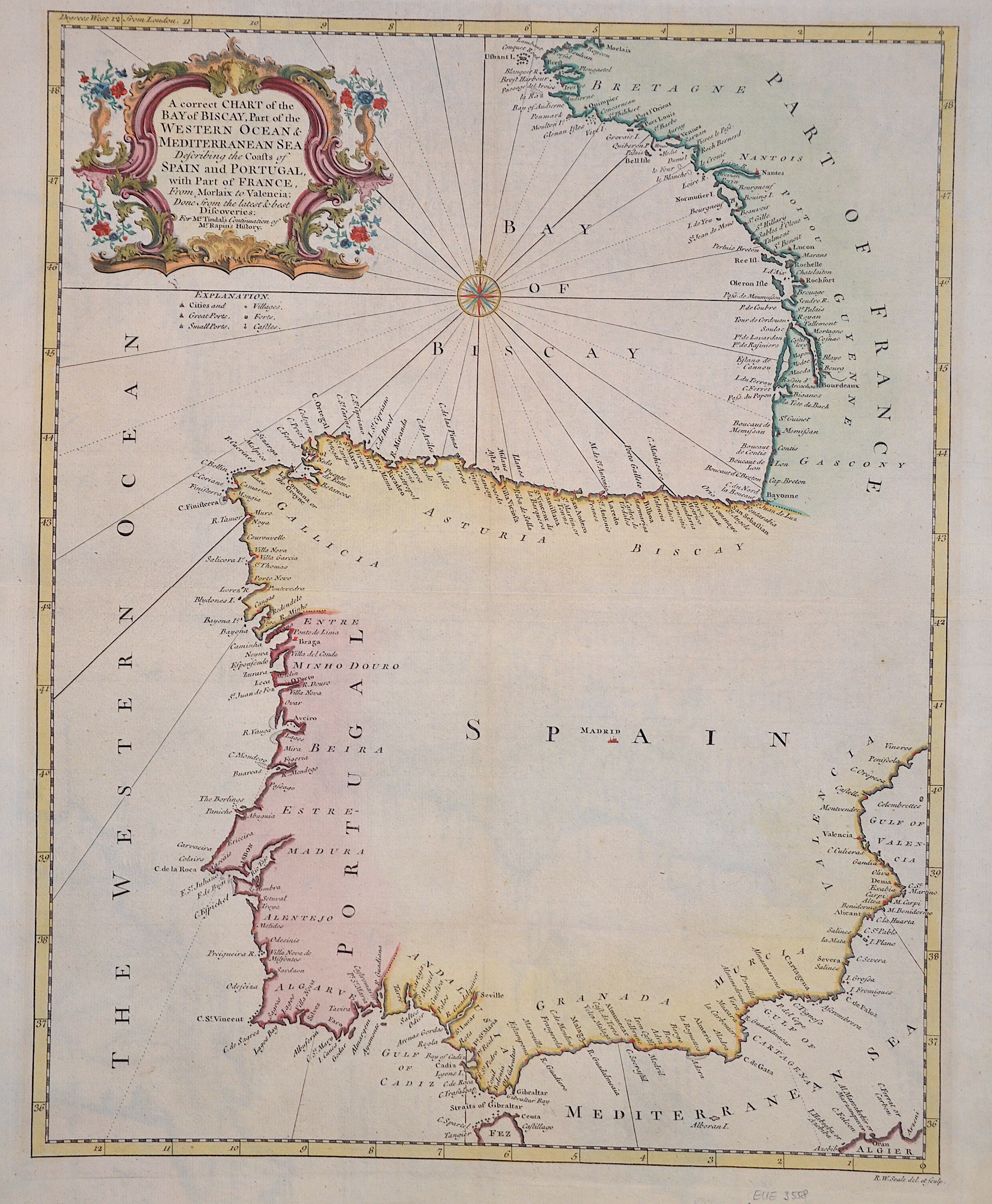
A correct Chart of the Bay of Biscay, Part of the Western Ocean & Mediterranean Sea Describing the Coasts of Spain and Portugal with Part of France.
| Article ID | EUE3558 |
Title | A correct Chart of the Bay of Biscay, Part of the Western Ocean & Mediterranean Sea Describing the Coasts of Spain and Portugal with Part of France. |
Description | This charts shows the spanish caost with the Biskaya, also Portugal and partly France. |
| Year | ca. 1700 |
Artist | Rapin de Thoyras (1661-1725) |
Paul de Rapin de Thoyras ( 1661 – 1725), sieur of Thoyras (and therefore styled Thoyras de Rapin), was a French historian writing under English patronage. The son of Jacques de Rapin, an avocat at Castres (Tarn), he was educated at the Protestant Academy of Saumur, and in 1679 became an advocate, but soon afterwards joined the army. The revocation of the Edict of Nantes in 1685, and the death of his father led him to move to England; but, unable to find work there, he went on to the Netherlands where he enlisted in a company of French volunteers at Utrecht, commanded by his cousin, Daniel de Rapin. He accompanied William III to England in 1688, and during the Williamite war in Ireland he took part in the Siege of Carrickfergus and the Battle of the Boyne, and was wounded at the Siege of Limerick (1690). Soon afterwards he was promoted to captain; but in 1693 he resigned in order to become tutor to the Earl of Portland's son. After travelling with the boy, he settled with his family (he married Marie-Anne Testart in 1699) in Holland, first at the Hague, then,at Wesel, in 1707. | |
Historical Description | In prehistoric and prehistoric times, Iberians, Celts and Basques settled on the Iberian peninsula named after the former. In the 11th century BC The Phoenicians settled on the south coast; the most famous of their colonies was Cadiz. The name Spain is derived from the Roman name Hispania (from Phoenician ishapan "land of the rock hyrax". In the early 8th century, the Moors destroyed the Visigoth Empire and conquered the entire Iberian Peninsula. Their centuries of rule shaped the country. The Arabic heritage was reflected in both the architecture and the language. However, the Moors were unable to establish themselves permanently in the northern outskirts of the peninsula. From there the "Reconquest" (Reconquista) started. In this process, which spanned several centuries (722–1492) and was not continuous, the Muslim empires were gradually pushed back by the Christian empires until the fall of Granada in 1492, the last Moorish state structure on the peninsula also disappeared. In the 15th century, the kingdoms of Castile and Aragon were united. Aragon was an important maritime power in the Mediterranean at that time. The Spanish colonial empire extended around 1600 across large parts of South and Central America, the southern part of today's USA and the Philippines. As the English and French also intensified their colonial efforts, Spain gradually lost its supremacy. The liberation wars of the American states, particularly the Mexican and South American wars of independence in the early 19th century, brought independence to most of the colonies. In 1898, the last major properties were lost to the United States during the Spanish-American War, which meant the end of the colonial empire. The African colonies that followed later (Spanish-Morocco, Spanish-Sahara and Equatorial Guinea) finally became independent in the 20th century. |
| Dimensions (cm) | 47 x 37,5 |
| Condition | Perfect condition |
| Coloring | colored |
| Technique | Copper print |
Reproduction:
57.00 €
( A reproduction can be ordered individually on request. )